 bNomadic
The following is a page entry from On Road through the trans-Himalayas. To read complete travel memoirs and trip report, please visit here.
Chapter 7 of 22

Om Mani Padme Hum
Next morning after the daybreak, loaded with limited supplies that would last us a day, we started the steep climb towards the pastures of Kaza. The seven-kilometre sheer ascent took us to the village Langza (4420m). Although, the village was recently connected with a narrow jeep-track over the steep Shilla Gorge, we preferred taking the harsher approach as the guesthouse-owner had warned us the previous evening about road-repair work currently undertaken by the PWD department which meant the road could be closed for traffic movement. Otherwise the village is now connected with a narrow jeep-track to other neighbouring villages including Gette, Tashigong, Hikkim, Komic, etc.

Landscape towards Kaza; captured from slopes. For more pics of the region, please visit bNomadic in Spiti
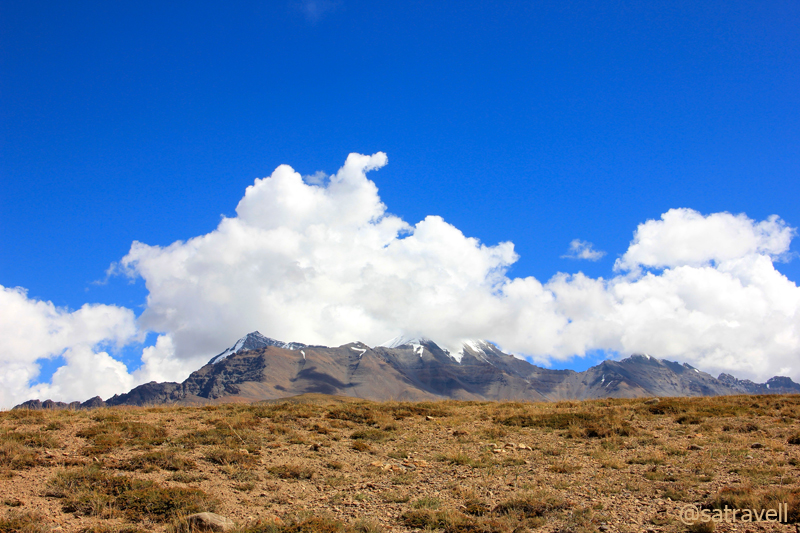
First views of the veiled Chau Chau Khang Nalda. For more pics, please visit Flickr Photoset on the region
Huffing and puffing we reached Langza in about four hours to come within a handshake distance with the magnificent Chau Chau Khang Nalda (6303m), literally meaning the mountain-princess on which the sun and moon shine. I had earlier read about its astonishing beauty in the Himalayan Journal edited by Harish Kapadia. The gigantic mountain rises suddenly and appeared to be positioned in the backdrop of the village in the laps of the vast expanse of shrubbery around. Eclipsed by a small cloud, the mountain peak, like a newly married bride, refused to reveal its real face the entire duration that we stayed there.

Village Langza and the CCK Nalda
The statue of meditating Buddha – sitting cross-legged – on a mound above the village overlooking the Zanskar and Great Himalayan Range, as well as the newly-renovated village monastery made the visit to the picture-perfect village even more incredible. As per the Bhaisajyaguru Sutra, this posture, also referred to as Medicine Buddha symbolises the Buddha’s meditation to ward-off any disease inner as well as outer. The preservation of local flora and fauna could rightly be attributed to the teachings of Buddhism. The followers of Buddhism in the trans-Himalayan region imbibe in them the motto Live and let Live.
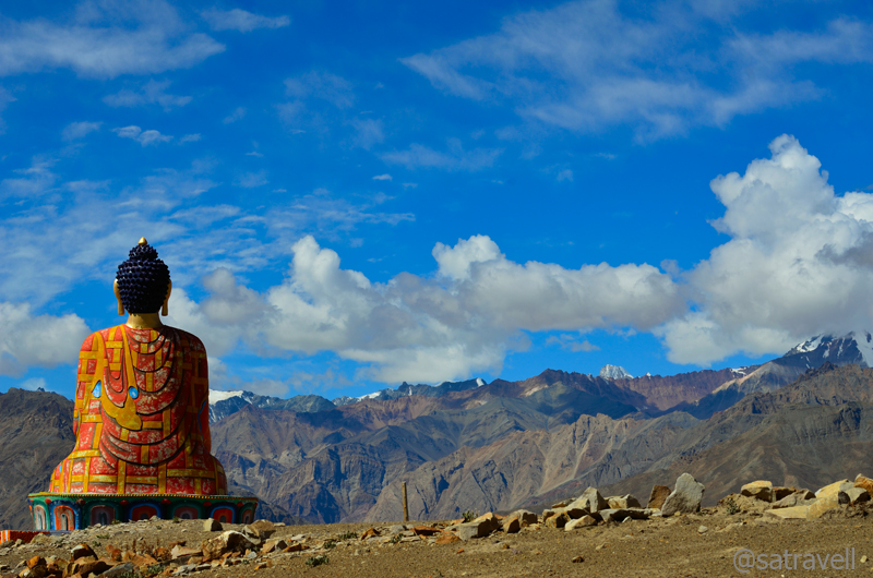
Medicine Buddha. For more pics of the region, please visit bNomadic in Spiti
Lacking overgrown vegetation, the rounded meadows, a treasure-trove of fossils, made for a perfect camping ground. One needs to carry own tentage armed with supplies to make it safer though home-stays are also popular here. Farther out to pastures are still more sites, each with its own wealth of undersea-fossils and viewpoint. Reminisce of earth’s internal movements, the vast and arid terrain, once a sea, is said to record every geological age in pristine formations. Inching skywards, the Greater Himalayas that enclose Spiti in a crescent, prevent moisture-laden clouds from reaching the region thereby creating an arid and desolate landscape.
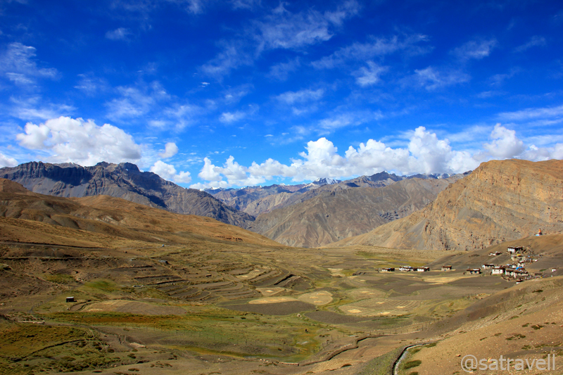
Meadows and cultivated fields of Langza. For more pics, please visit Flickr Photostream
From the village Gompa, a 360 degree view encompassed almost every topographical feature of the trans-Himalayan region including deep gorges, the awe-inspiring heights of snow-capped mountains as well as ridges, rippling mountain ranges, expanded river basin in wide open valleys, intriguing rock formations, sloshing glacial rivulets, rich flora as well as fauna and expansive meadows, etc. Extending from Nanga Parbat Peak in the west to Namcha Barwa in the east, the Himalayas are not only known to be widest in this western region but are known to possess most intricate geological mysteries.
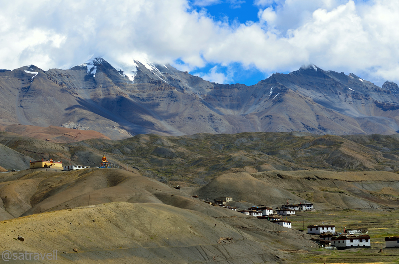
Village Langza and the Gompa. For more pics of the region, please visit Flickr Photostream
Known as Western Himalayas in the geographical parlance, the area comprises the region west of the Tons-Yamuna gorge right up till the Indus in Pakistan occupied Kashmir (PoK) as well as north of Shivaliks until the snowy peaks towards the northeast direction, which also marks a natural boundary with Tibet. Travelling northwards, the various mountain subsystems that come under the Western Himalayas are the Shivaliks, The Outer Himalaya Range, The Mid-Himalaya Range, The Great Himalayan Range and The Trans-Himalayan Region. Unlike the ranges in the lower Himalayas, located southwest of the Great Himalayan Range, that rise in succession one after the other, the trans-Himalayan region is largely a featureless expanse of high-altitude desert terrain.
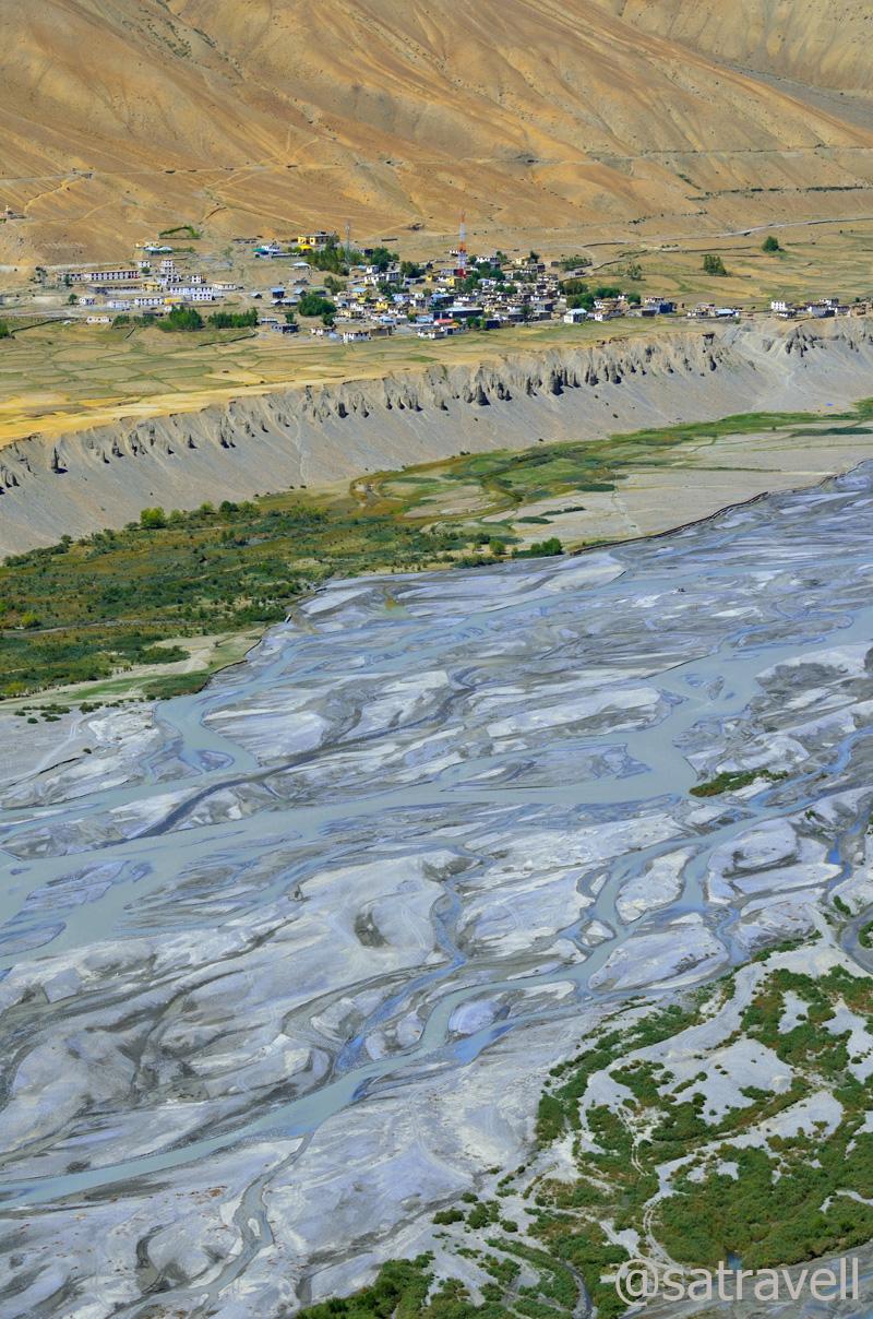
Colourful Spiti riverbed and village Rangrik captured from Bhar slopes
Geographically, the trans-Himalayan region lies northward of the Great Himalayan Range, which after reaching its crescendo drop away forming several ranges as well as ridges running parallel to itself. With elevation ranging from 4500-7500 m, the significant ranges of this region are christened as Zanskar, Ladakh and Karakoram, etc. The topography is sliced into numerous valleys by one of the most prominent river-systems including the Indus, the Spiti, the Sutlej and the Chenab (Chandrabhaga), etc. Culturally, the regions are linked by a common thread including architecture, religion, practices, food, etc. with minor variations related to language differing with valley to valley.

View towards the Tud region
Submitting to the stubborn massif that refused to reveal itself, we took a few photographs and left the dreamland facing strong headwinds downhill. On the way I captured myriad perspectives the landscape had to offer including that of the Kanamo Peak (5964m). With a limited zoom, photographing the shy birds, up there, was always a problem. We were back in town, before the light faded, where a sumptuous feast awaited us at the guesthouse.

Captured while descending Bhar slopes. For more images, please visit bNomadic in Spiti
View and read more on the region at the Flickr Photostream of bNomadic
You may also like to subscribe to the email updates, of the remaining chapters, by entering your email id in the sidebar.


Pingback: On Road through the trans-Himalayan Region | bNomadic
Beautiful photography!
Thanks for visiting my page and showering it with appreciation. Hope you’d visit again.
Nice write with tons of info and lovely pictures.
Thanks for visiting my page Mr Arumugam. Thanks for the encouragement. Hope you’d visit again .
Mesmerizing captures ! 🙂
Thanks for the lovely feedback Aziz ji.
take me in your group bro !! one more post with such heavenly snaps and I will pack my bag in search of nirvana
You are always and ever most welcome to join me Sir. Thanks for being a constant source of motivation and encouragement.
🙂 i should thank you for sharing heaven on earth through your awesome post dear nomad friend of mine 🙂
Thanks for showering with appreciation and encouragement.
Wonderful images ! Love to these locations 🙂
Thanks for the feedback Uma. Hope you’d keep visiting the blog.
Beautiful. .
Have a nice day!
http://www.ourjaipur.com
Thanks for the feedback. Best wishes,
nice work….God bless
Thank you Sir for the feedback and visiting my blog. Hope you’d visit again.
The pictures are serene and very authentic! Totally mesmerized me….
Thanks for showering with appreciation and encouragement Deepti. Spiti is such a region; offers myriad angles to capture.
Amazing like always…
Thanks admin for the feedback. Hope you’d keep visiting.
Spell binding!
Thanks admin for the feedback. Hope you’d keep visiting. And encourage me. 🙂
A gripping accont of the Himalayan journey with beautiful pictures of a number of serene spots.
Thanks Kajal for visiting my blog and showering with appreciation. Hope you’d visit again.
Lovely informative post in your Great account with wonderful landscape pictures!
Thanks for visiting my blog. The region offers myriad perspectives waiting to be captured. Keep visiting often .
Pingback: Bumping into a rare four-legged wild creature | bNomadic
Pingback: The Highest inhabited village in the World | bNomadic
Climbing up the slope of Bhar pastures | bNomadic
Thanks. 🙂
Brings back memories 🙂 Great pictures! Thanks to you, I now know the names of some of the peaks I didn’t earlier.
Thanks admin. Langza was actually the best part of my Spiti trip. Keep visiting. 🙂