 bNomadic
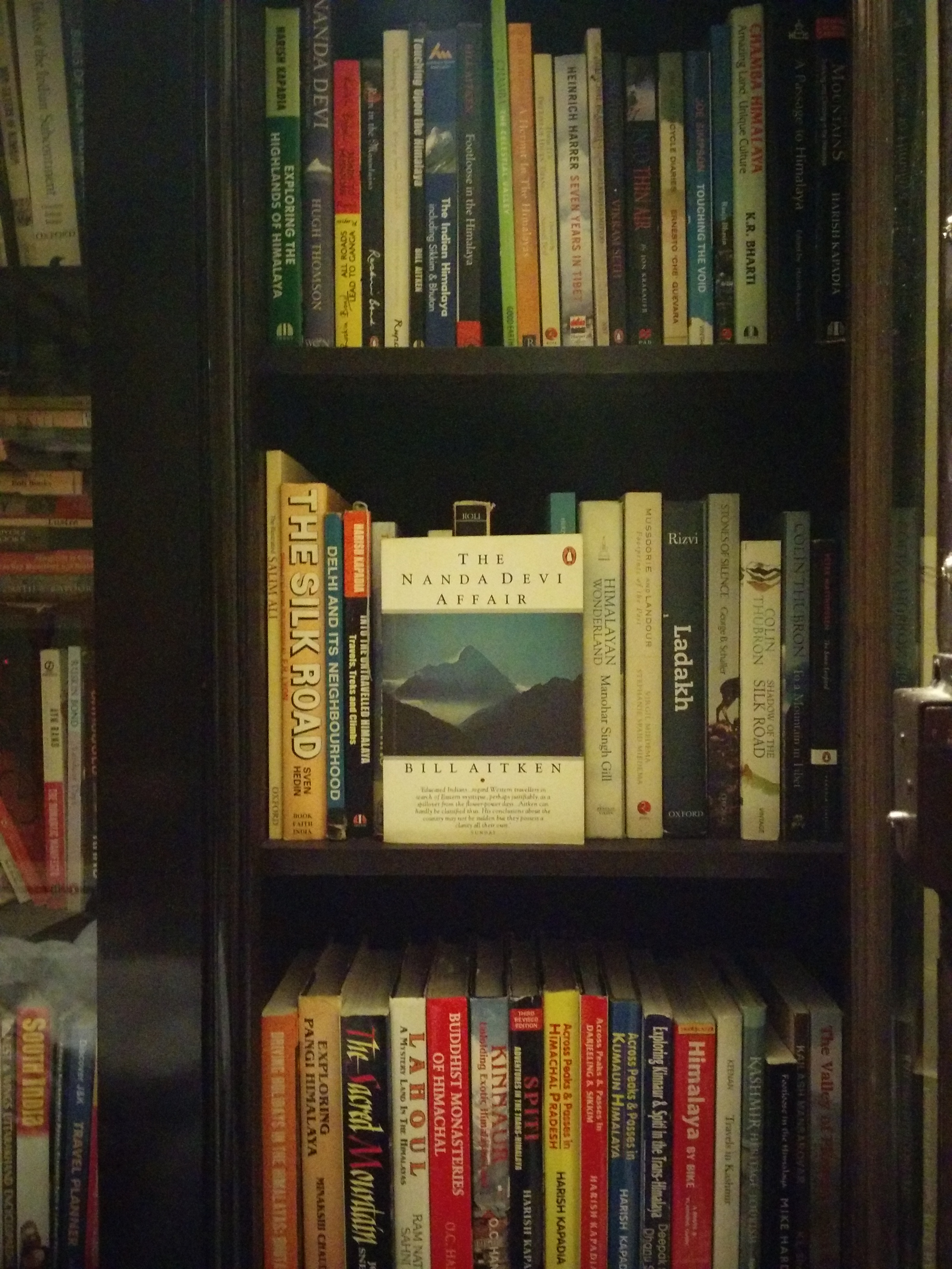
Book Talk: The Nanda Devi Affair
This is yet another book that has reserved a place for itself in my bookshelf dedicated to travel writings. Not so much for the author Bill Aitken’s travels or trekking escapades but because the book reliably captures the aura surrounding the forever mysterious mountain peak of Nanda Devi. Even after two decades when it was first written, the book continues to be popular and one of the most easily available resources on the subject.

…One of the most easily available resources on the subject…
Originally published in 1994 by Penguin, the latest reprint of the book is priced around Rs 299. Surprisingly, the publisher has mulishly disregarded a better typesetting in all its reprints including its original edition. In about 194 pages, the author talks about the mountaineering history and his fascination towards one of the most beautiful and revered high-altitude regions of Himalayas, the Nanda Devi biosphere.
It was legendry Eric Shipton‘s mountaineering literature classic, The Nanda Devi, which he wrote after he had successfully discovered the treacherous route to the base of the mountain that eventually inspired Bill Aitken to make a determination that come what may, one day he too would cross the blooming Rishi Gorge and win a way to this Hindu Garden of Eden. Having fled Britain because of a failed love affair, Aitken, a young Scot, claimed to have his true home at the mountain’s feet. “The affair with the ravishing Goddess had occupied a third of my life,” he writes.
In part through his travels and explorations spanning almost three decades as well as by way of acquiring knowledge through various published and unpublished chronicles pertaining to the region, he writes about the Nanda Devi, patron Goddess of Kumaon and Garhwal. As he begins to talk about his hikes through the hillsides of the dev bhoomi Uttarakhand, he gradually approaches the subject after giving inkling to the absorbing hill life. While doing so, he briefly touches upon the routine ordeals faced by the hill folks against the difficult terrain and painful weather as well as history and traditions in the light of the beauty and divinity associated with the high mountains. The arresting ecological as well as geographic features of the Nanda Devi continue to propagate a religious craze in the region and the sacred peak is considered to be the seat of Goddess Parvati.
From featuring the best viewpoints in the Kumaon region that offers an extraordinary sighting of the Nanda Devi to the contributions made by the legendary explorers right from Shipton, Tillman, Roskelley, Longstaff, Curzon, Traill, Ruttledge and even Pranavananda, Atkinson, Sax and Odell, etc. in highlighting the confines of the sanctuary, Aitken has tried to capture all. Wherever deemed fit, he would vent his frustration at those who threaten the peace of these mountain abodes: be it the bigheaded babus at the Indian Mountaineering Foundation (IMF)’s Delhi office or the musk smugglers to the incompetent forest officials to the secret Indo-US mountaineering assignment in which a nuclear-powered spying device was proposed to be installed atop the Nanda Devi as well as the pushy professional climbers who cared a fig about the environment of the sanctuary that ultimately led to its closure. “Sara Kailash chut hagi – the entire mountain had been polluted, “he quips.
The book has reserved a place for itself in my bookshelf
Initially, Aitken’s style of writing might appear to be complicated and one might judge him for his condemnatory outlook but the passion speaks for itself and his love for mountains is visible everywhere. The Nanda Devi Affair is undoubtedly the author’s bestselling and most popular book full of anecdotes related to the mountain as well as the land and the people surrounding it. His other published works include Touching Upon the Himalaya: Excursions and Enquiries, Mountain Delight, Footloose in the Himalaya, Seven Sacred Rivers and Riding the Ranges, etc. You may like to buy the book online here, here or here.
Gadget and Gear Talk: Sony 10,000 mAh Power Bank
I am surely not a gadget freak but travelling certainly becomes more productive and convenient with the help of technology. The intent behind discussing gadgetry here is to help you make an informed choice, through my own experiences, when it comes to assessing the usability, design, functionality as well as compactness of the gadgets and gears deemed necessary. The idea behind introduction of this category on bNomadic is to provide you with some assistance in prioritising your options.
Having earlier used a Chroma-manufactured as well as an iTek device to backup power for my handheld smartphone, I recently bought a Sony product. Pointless to write, both of the previous devices which I received as freebies proved out to be complete disasters against the Sony power bank. I preferred Sony over other alternatives for its reliability as a brand as well as the heavy duty 10,000 mAh capacity offered by the power bank. Ordered online through amazon.in in July 2014, I’d now say that have been using this for quite some time now.

The Sony CP-F10L Power Bank
What is in the pack?
The battery, a palm-sized USB – micro USB connector cable and a multi-lingual guide leaflet
The Sony CP-F10L Portable Power Charger comes fitted with two, energy efficient, lithium-ion rechargeable cells which together provide a mammoth capacity of 10,000 mAh. The ultra slim aluminium wash-soap bar sized power bank is quite the convenience to be carried while traveling. The device provides with two USB ports that can simultaneously charge two gadgets with a maximum of 3.6 Ampere taken together. In other words, if used at the same time both output ports can easily spurt a minimum of 1.5 Ampere. The listed dimensions are 70.4 X 130.6 X 16.5 mm and it weighs 260 grams which is reasonably substantial but tolerable considering its heavy-duty capacity. The device takes about seven hrs through a DC 5.0 V adaptor (1.5A) and 23 hrs through the USB interface of the computer to fully charge itself.
I won’t say that I have tested this product per se; nevertheless, I routinely use this product to the nth degree. Just to indicate its usage, it completely fills my Nexus 5 device running on 2300 mAh battery in just about an hour and five minutes, which is less than half the charging time from Nexus’s original charger. On the other hand, the Moto G on 2070 mAh takes less than an hour. The faster charging is also due to the higher charge generated by the power bank. Even though, as mentioned on the device, the real capacity of this device is about 67 per cent or 6700 mAh, normally, I have been able to charge my Nexus 5 smartphone thrice before recharging the power bank. Apparently, the loss of capacity is due to factors like voltage conversion and circuit resistance, etc. In between charges, the standby time for the power bank is found to be more than three days which is quite useful on extended journeys.

The Moto G on 2070 mAh takes less than an hour
Although the original Sony adaptor to charge the CP-F10L is sold separately and as the device requires an input of DC 5V (0.5A ~ 1.5A), I use just whatever comes my way, mostly the regular smartphone-adaptor, to charge it. The charging time varies accordingly. Instead of flashy LED displays that drag battery charge, the device comes equipped with smart light – green and orange – indicators which specify battery charge and function as well as malfunction. Just plug in to charge and stop worrying, because the Sony power charger incorporates certain much-needed safety features like overcharge protection as well as abnormal temperature detection. Not that I have so far used it at higher altitudes, the operational temperature range for the device is listed as 0 – 35 degrees Celsius but works best between 10 to 30 degrees Celsius. The battery drags faster at lower temperatures.
Overall, the build quality of the internationally compatible Sony power bank is fleckless and is fit to be used ruggedly. I found this charger to be the smartest companion, other than myself of course, my devices including Nexus5, iPad or kindle may ever have while I am travelling. The current cost of this portable charger is around 3400 INR which is on the higher side. As battery banks are more of a necessity these days while travelling, I suggest this (or a similar one) to be in the list of must-haves.
 Please Note
A lot of fake power banks, across all popular brands, are being sold online. Doubly check before making a purchase.
Kinnaur Diary; The unceasing charm of Baspa Valley


A recently installed statue of Buddha overlooks the temple courtyard at Kamru
As I began to recollect my experiences based on my visits to the spectacularly beautiful Baspa Valley, I felt that a wholesome travel-post on this activity-rich area would warrant a longish description. To make the reading more meaningful, I now plan to introduce a hiking section on bNomadic so as to relate my trekking escapades and other adventures from this as well as other regions. The ensuing post talks about the travel wealth of the Baspa.

“This is the most romantic of the Himalayan valleys” Please visit Flickr for more images of the region
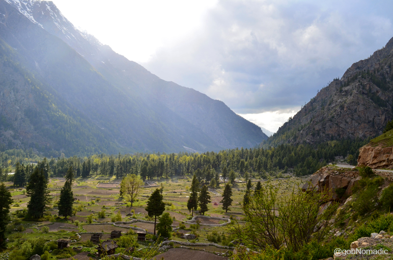
The Baspa Valley, also called Sangla Valley, conjures up images of the enormity of mountain ranges, comforting views, the richness of culture, forested faces higher up, agile fauna as well as friendly faces. The moment one takes the diversion along the Baspa River from Karcham, located at a distance of about 50 km from Rampur, on the dusty NH22 (formerly called Hindustan – Tibet Road) in the Satluj Valley, the magical spectacle of Baspa Valley begins to unfold itself. The calm Baspa River cleaving the gorgeous carpet of subalpine vegetation flanked by Dhauladhars to its left and Kinner Kailash range to its right, exhibits a spectacle which only comes closest to the place where God lives.
About 90km in length, the river happens to be the second largest tributary to mighty Satluj in Kinnaur. The road, 42km in length, connecting various settlements of the valley lies on its true right bank all the way up to village Chitkul, located at the other end. For the initial 18 km skirting Rutrang till the wide expanse of Sangla, the administrative headquarters of Baspa Valley, the road is narrow and treacherous in parts. As we inch ahead deeper into the valley from Karcham, the river Baspa adorns its calmer look. Legend has it that the race between Baspa and Satluj to reach Karcham first was responsible for the ferocity, now absorbed by the reservoir of power project, of Baspa downstream as it prepares to merge into the mighty Satluj. The myth is also related to the curious absence of chilgoza pines from the forests of Baspa valley.
The fertile valley bed is neatly laid out in fields of peas, beans, turnips as well as finest quality of potatoes

The western ousters of Pk Raldang. Please visit Flickr Photoset for more images of the region
Past the last bit of live slide area on the motorway, the hydroelectric power project of Sangla comes into view. With the main village of the valley, Sangla (2650m) spread on the right bank of Baspa, the valley region ahead acquires the shape of a bowl. It is believed that this part of the valley was once a sheet of water and from the general geological evidences present nearby, one would tend to believe it. The river gently meanders along in an expanded bed of sand and pebbles creating numerous channels. The terrain here is neatly laid out in fields and gardens of peas, beans, turnips, finest quality of potatoes as well as dotted with rural cottages. There are plentiful shaded groves of apricots, the recently introduced varieties of apples as well as walnuts that bless with a cool retreat.
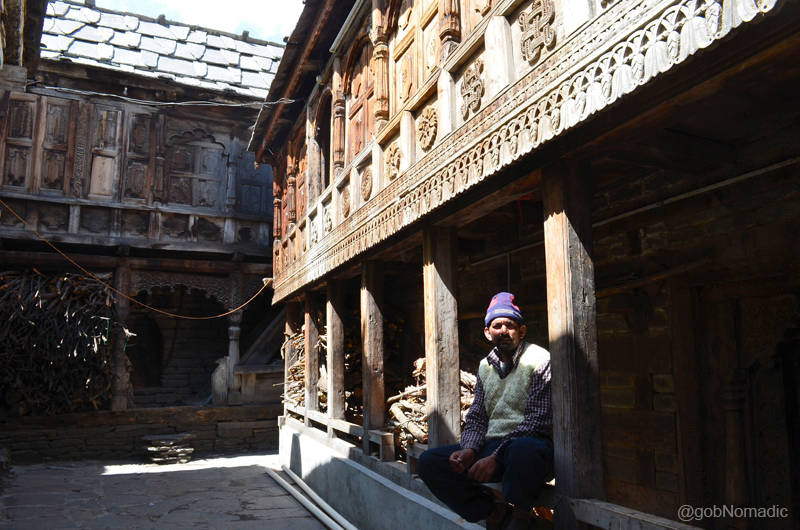
The courtyard of a traditionally kept house at Kamru. Notice the woodwork which is practiced in Kinnaur.
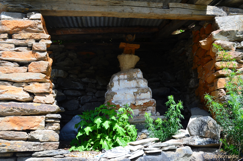
A roofed chorten spotted at Kamru. Please visit Flickr Photoset for more images of the region
Ever since the government had allowed visitors to Kinnaur, the area has been witnessing a continuous increase in travellers and tourists influx. From a village of not more than 50 families during the trade-route days, today, Sangla is fast bracing itself to cater to the needs of “touristy brigade”. Owing to its proximity to both Tibet (via Satluj Valley) and the “terrain of Hindu Gods” Garhwal (over the high passes), Sangla retains best of both worlds. Sangla used to be a meeting place for traders from Garhwal and Tibet. During those times, owing to the treacherous terrain of the HT road, the Baspa Valley used to be the preferred diversion for both travellers and traders to enter Kinnaur part of the Satluj Valley to reach Shipki La. The then Vicerine of British India, Lady Canning crossed the Dhauladhars through Rupin pass in 1860 to reach Kalpa.
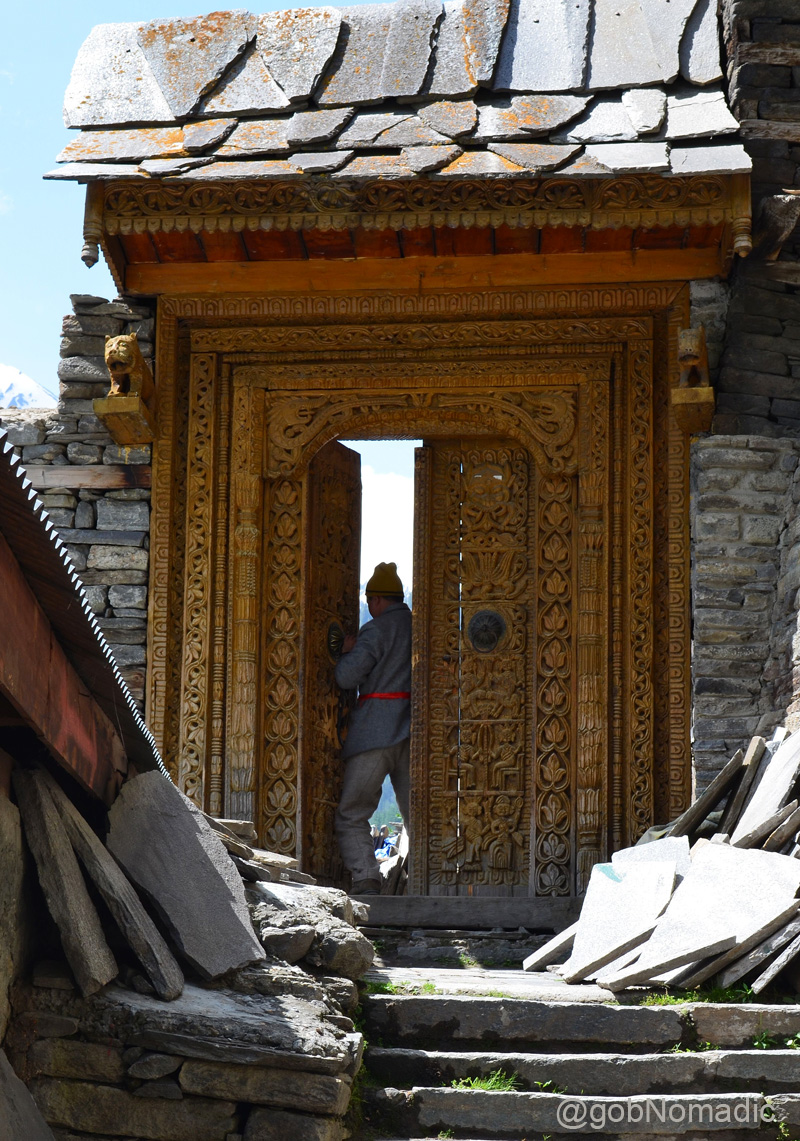
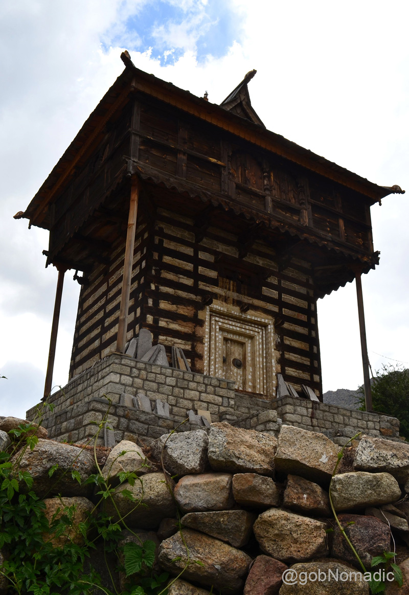
The intricately carved entrance door to the Kamru Fort
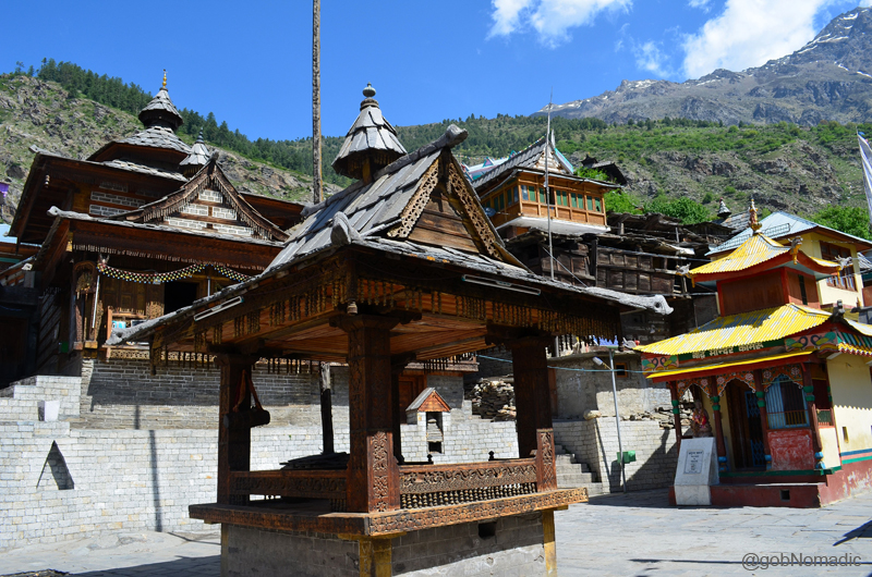
The Kamru (formerly called Mone) temple complex. The recently built Drugpa Monastery is also in the frame.

“Even after the Bushahr capital was shifted to Sarahan and Rampur, the enthronement ceremony continued to be performed at the impressive fort of Kamru (Mone)“. The fort also has an enclosure with a deep well, in which, it is claimed, criminals were kept. Please visit Flickr Photoset for more images of the region.

Ancient temples within the compound of the Kamru Fort. The olden temple was built by a Bushahr King after his forces had successfully withstood an attack by Tibetan chieftains. More images at Flickr Photoset
Streaked with snow, the immense western clusters of the Raldang peak towering above the settlement of Sangla, reminds one of his presence in the vicinity of the colossal Himalaya. Looking up the slope one would notice the spread of the settlement of village Kamru located obliquely above Sangla. Commanding a wider view of the valley, Kamru (2770m) is home to the most striking monument of the Baspa Valley – the Fort of Kamru Narayan. The pathway to the Fort-cum-temple complex of Kamru branches off the valley road near the PWD facility at Sangla. Although, the complex was said to have been recently renovated, entry inside the Fort was still not allowed owing to its dilapidated state. Past the superbly carved main entrance, the tiled courtyard houses an ancient shrine devoted to Kamakhya Devi, the Durga’s incarnation in Assam as well as a small Buddhist temple. The presence of olden mani walls and chortens in the settlements of Sangla confirms the decided presence of Buddhism, along with Hinduism, in the valley. The presiding deity of Sangla is Nag Devta.

A section of the valley bed as observed near village Batseri. Please visit Flickr Photoset for more pics
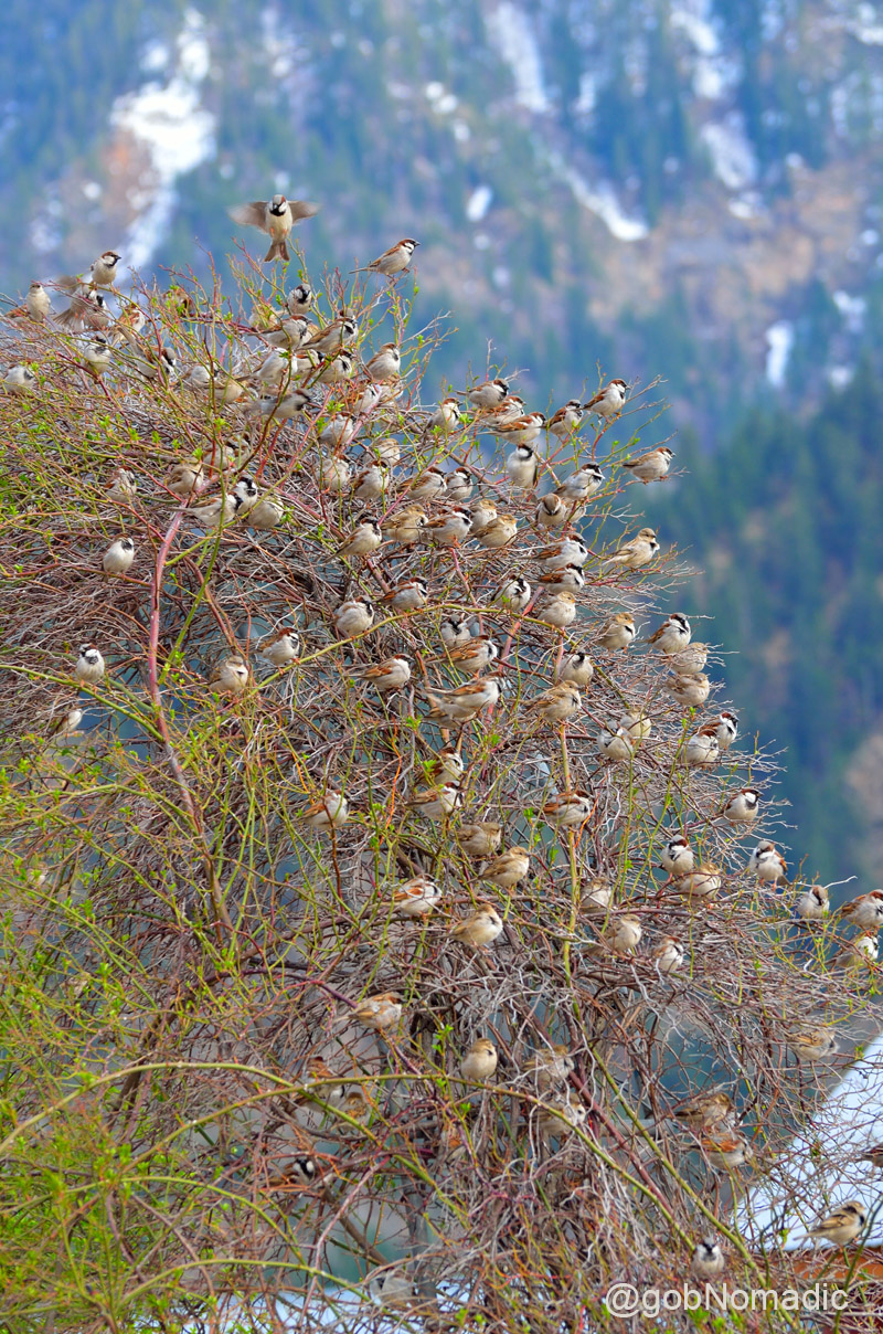
House Sparrow “Tree” at Sangla
The portion of the valley from Kamru right up to the fields of Chitkul at the other end of the motorable road retains some of the most memorable Himalayan sights. The road passes through Rakcham (3115m), 12 km further up from Sangla, and Chitkul located at a distance of 12 km towards the head of the valley. The Baspa here rolls smoothly on pebbles with a gentle murmur, or rushes with rapidity in a narrow stream creating tiny islands full of wild berries, surrounded by blue pines, willows, hazel and sweet briar, etc.

The last bit of stretch; a few km before Chitkul. More images from the region at Flickr Photoset

Village Chitkul in sight. More images from the region at Flickr Photoset
The village Chitkul (3450m) is the last and the highest village in the valley. Owing to the increasing tourist activities, a few guesthouses and hotels have now sprung up in this otherwise a sleepy village. The village houses an olden temple complex dedicated to Mathi Devi, its presiding deity, said to be a consort of Kamru Narayan. The view from the village would remind one of trans-Himalayan mountain-scape. The verdant cultivation, or now and then scantily wooded with a few stunted pines, is strongly contrasted with the barren faces of rugged rocks on either hand which present naked and impracticable crags frowning in a terrific forms.
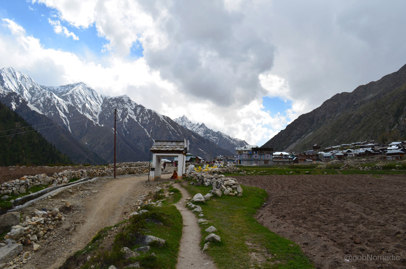
The settlement of village Chitkul. Please visit Flickr Photoset for more images of the region

The view from the village Chitkul reminds one of trans-Himalayan mountain-scape. More images at Flickr

Sarabjit showing results of his camera to the local kids
Part of the Mathi Devi temple complex, the Bara Qila at Chitkul. The temple is said to be over 500 years old.
The grandeur of the mountain-scape offers fresh perspectives on the return journey as well. Impressed by its richness, Capt Gerard, one of the first to record a visit to Kinnaur, wrote in his book Account of Kunawoor, “this is the most romantic of the Himalayan valleys and it is difficult to imagine a more beautiful spot”. Later logs have been equally full of praise about the beauty and magnanimity of this valley.
Not only for its sheer beauty, the Baspa Valley is known for its skilled wood and metal craftsmen. Apart from fruit and veggies, the valley is also popular for trout farming, particularly near the flat valley bed around village Batseri. In terms of travel lure, Sangla valley is a paradise for Himalayan lovers and photoartists as well as trekkers. The most popular of all trails is the day hike up to Sangla village pastures known by Sangla Kanda. Another popular hike is the easy walk up to Nagasthi, the last Indian outpost in the valley towards border. The valley also happens to be on the route of Kinner Kailash parikarma. For the expert ones, the most popular option is Chitkul to Har-ki-doon or Harsil trek. A few frequented passes around Sangla valley are Charang, Rupin, Khimloga, Lamkhaga, Borasu, etc. Foreigners would, however, require permissions from the concerned authorities to crossover a few of these passes.

A female Siberian Stonechat. Please visit bird gallery at Flickr Photoset

Blue pines by Shushang Nala in the Mostrang section
The valley offers ample accommodation avenues for backpackers or holidaymakers. However, my favourite would remain the PWD or the furnished HPSEB guesthouses. Built in 1908, the spacious British-era Forest RH is located amidst a thick forest across the river near Sangla. The preferred route from plains, to reach Sangla, would be Chandigarh – Shimla – Theog – Narkanda – Rampur – Jeori – Karcham – Sangla. Narkanda would be an ideal night-halt.
Average Altitude: 2800m
Best time to visit: Spring and autumn
Travel Lure: Landscape and wooded trails
Accommodation: Limited but usually available
Book Talk: Dreams of the Peaceful Dragon
Earlier this year while preparing for my Bhutan trip, I stumbled upon this narrative written by British travel writer Katie Hickman on her journey through Bhutan spanned over a few weeks. Her travel memoirs to Bhutan have been relatively popular in the European travel circles.

A Journey through Bhutan by Katie Hickman
Back in early 1970s, she happened to be one of the few known European travellers to be allowed an entrance into Eastern Bhutan. Internationally, first published in 1987, the India edition of the book was made public much later in 2012 by Timeless Books. In about 190 pages, the author chirpily writes about the routine tussles between her adventurous self and her discoveries or findings upon landing in an area.
Before 1974 when tourism in Bhutan was formally opened for foreigners, the only non-nationals permitted in were guests of the royal family. Katie chanced to be one of the very few visitors who could manage an invite by the royal family. Initially permitted for a week, the queen not only generously extended her stay by a few weeks but provided her with a guide and related paraphernalia to visit the tribes of Eastern Bhutan.
Partly on four wheels, in part on ponies and the remainder on foot, she along with her photographer travel-companion Tom Owens travelled east from Thimphu to Bumthang and Tashigang. Their journey maxed out at the far eastern villages of Mera and Sakteng dominated by the bragpa tribe. Her memoirs provide a casual insight into this region that was, until recently, relatively untouched by the outside world.

An insert in the book maps her travels through Bhutan
Be it the evocative images of phallus, the talks about yeti, continuous torture of blood sucking leeches, the performance of the weed consuming horse, jitters created by the homely lama or the welcoming bragpas, her ingenuous account leaves the reader with an interesting as well as pleasant imagery of the mystic Himalayan land. As she wisecracks in the beginning, “We do not only travel to find the truth, but also to rediscover the mysteries that are in life. Ours is a world in which few stones remain unturned”. Bhutan is a country that every traveller dreams of.
Yet, on the downside, despite the fact that her travels were supported by the Queen, in her attempt to present the hidden treasures of the Land of Thunder Dragon to the world outside, I feel that Katie has, like a babe in the woods, missed the boat in bringing forward the serenity and beauty of the raw countryside of Bhutan. Considering it was a maiden interface for both, one would expect a lot of treasure trove in the form of knowledge and first hand raw information on the region. Downheartedly, her narration has simply been condensed to her personal experience against the observed handicap of her prior lack of awareness about the traditions of the region specifically pertaining to religion, customs, Himalayan life and geography.
For a travel-fiction fanatic, the book is full of adventurous as well as necessary information and anecdotes to support the flow. All in all, if you are looking to buy just one informative read on the region, this one might not be able to foot the bill and in case you have the luxury to access some more than don’t miss this one. Overly priced at Rs 495, the book, nevertheless, makes for an interesting and candid read.
You can buy the book online at Flipkart.
Shimla Diary; The splendid vistas of Thanadhar


The Great Himalayan Range as observed from Thanadhar. More pics from the region at Flickr Photoset
Before last year, I got a chance to visit Thanadhar, the upper sidearm of the fertile and scenic Kotgarh Valley in Himachal Pradesh. Although interlinked and part of the same valley, the road to the settlement of Thanadhar branches off the link-highway, from Narkanda, a few kilometres before the settlement of Kotgarh. In about 30 minutes flat, we were able to cover the distance of 16 km between Narkanda and Thanadhar.
It was late evening and drizzling when I reached the Kotgarh Valley, popularly named as Apple Valley. Being an off-season, I didn’t face much trouble in fixing an accommodation for myself. More than the quality of property, I would remember the place for the extraordinary culinary skills of its cook. Later that evening, having consumed a copious amount of Rajma – Rice (one of the best I ever got to taste), I wondered about the next day’s activities. I was half expecting the views to be clear the following morning and accordingly I tentatively planned out a birding trail for myself.
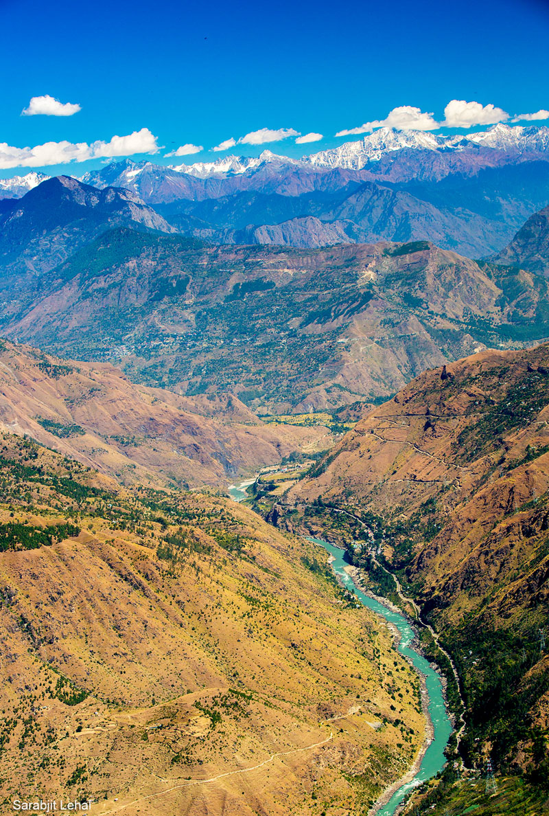
The mountainside of Thanadhar commands a panoramic view of the Satluj Valley. Photo Credit Sarabjit Lehal
The mountainside of Thanadhar commands a panoramic view of the Satluj Valley against the awe-inspiring Great Himalayan Range far in the distance rippling above Dhauladhars. Also billed to be Himachal’s horticultural heartland in the travel circles, Thanadhar (or Thanedhar) is located a little higher (2300 m) than that of Kotgarh (1950m). While key travel-activity areas would remain the same at both locations, most of the olden landmarks are located at Kotgarh. Full of significant evidences of the pre-independence days, a day-long stroll in the valley is sure to kick alive the fading memories of Raj era. Not only an annalist but the unobtrusive wooded groves of the valley would undisputedly entice a hiker, birder or a photographer.
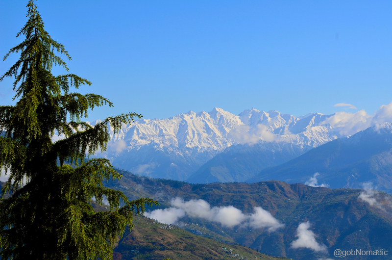
The awe-inspiring Great Himalayan Range far in the distance rippling above Dhauladhars. More pics at Flickr
The entire Valley started to prosper after the remunerative variety of apples was introduced to this region here in 1919 by Satyanand Stokes, an American missionary who later took up Hinduism. Ever since he initiated the commercial plantation of apples in one of his orchards on the slopes of Thanadhar, economically the region has not looked back. The protruding limbs of the mountainside all around us were terraced and channelled into myriad orchards of different sizes and shapes. Not only apples, the locals have productively engaged themselves in cherry farming, another speciality from the region.
Although, the hillside offers countless prospects for an enthusiastic birder, my favourite would always remain the one which connects the settlements of Thanadhar with that of Kotgarh in about three hours at a leisure pace. The trail, in part, passes through fertile apple orchards as well as the forest cover. On the way, one would notice forest-wealth in the form of Silver fir, Birch, Oaks, Deodars, Rhododendron as well as wild flowers. I would consider myself lucky because I spotted a Himalayan Weasel as well as a Yellow Martin. I would admit that I was fortunate to have got the best of both worlds on my way down to Kotgarh.

Locally called Puthir Chitta, the less common Verditer Flycatcher. More birds at Flickr Photoset

Locally called Shail Chirta, Rock Bunting perched on a apple tree. More bird images at Flickr Photoset
The smartest among the villages of Kotgarh Valley, Thanadhar has tapped the tourism potential better than most other settlements of the region. Apart from the splendid Himalayan vistas it offer, the credit of increasing tourism activities should also be given to the promotion of “fruit tourism” activities by the state. Led by a few commercial entities and some enterprising locals who rent out rooms and cottages, as part of their side business, the accommodation prospect has been aptly tapped to support the growing need of tourists and holidaymakers.
Famous for the annual festival at Nag Devta temple built along its shore, the Tani Jubbar Lake is located at a distance of six km from the market and feasibly could best be visited while coming from or going to Narkanda. The artificial water body may be tiny in size but offers quiet and scenic picnic spots around it. Other popular activities at Thanadhar include taking a walk to the Harmony Hill, Saroga Range, etc. Be it Rudyard Kipling’s reference “The Mistress of the Northern Hills” or the picturesque setting in Ustad Sultan Khan’s “Piya Basanti” remake video, the splendid charm of the valley continues to attract visitors from far and wide. For those who are still curious about the mountainside’s touristy bait, there’s absolutely nothing to do but eat, sleep, and soak up its antiquity and sheer natural beauty in the form of mountain-scape with birdlife.
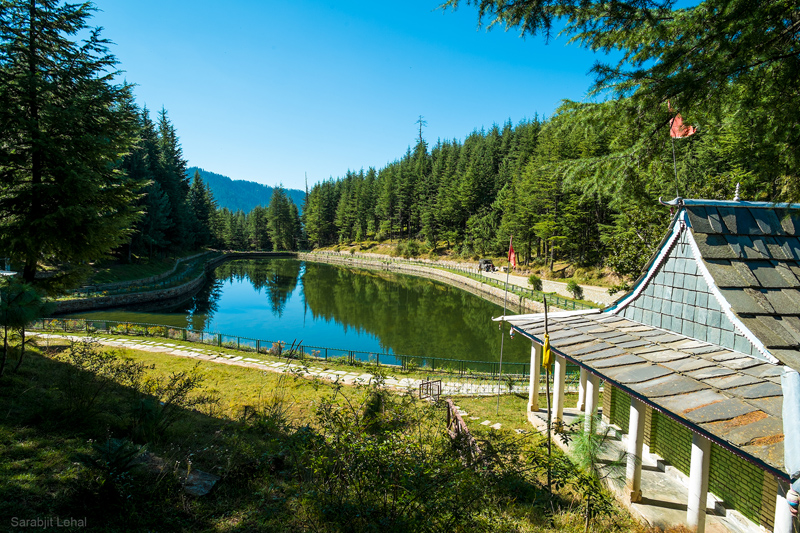
The Tani Jubbar Lake may be tiny in size but offers quiet and scenic picnic spots around it. Photo Sarabjit Lehal
Average Altitude: 2300m
Best time to visit: Throughout the year; particularly after monsoons
Travel Lure: Landscape, Orchards and wooded trails
Accommodation: Limited but usually available


