 bNomadic
The following is a page entry from On Road through the trans-Himalayan Region. To read complete travel memoirs and trip report, please visit here.
Chapter 16 of 22
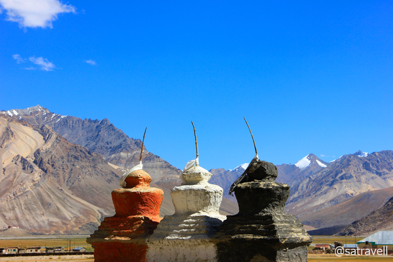
Entrance to Rangdum Valley by tri-colour chortens; the tri-colour – Black, White, Red (Ochre) – on chortens in trans-Himalayas symbolize a worldview – underworld, sky, earth – much older than Buddhism itself. More at Flickr
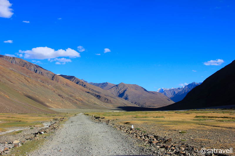
Located in an awe-inspiring barren mountainscape and surrounded by steep hills, orange-shaded pastures as well as streams, the village Zolidok or Juldo is a popular breaking point for travellers en route the Kargil-Padum motorway. Part of Rangdum area, the village houses a few basic guesthouses, dhaba-cum-teashops, JKTDC property, PWD rest house as well as a mandatory police check post which is located a little off the road. We straight headed to the police check post to submit our details. After two-three knocks at the door, the policeman ,who had just finished off performing namaaz, appeared and asked for the details. The most amusing part of his questionnaire was, “Why do you want to travel into this desolate territory”?

Flat-roofed houses at Zolidok. More pics and info of the region at Flickr Photoset
Having submitted the details, we headed past the village houses towards the Pensi La. Located a few kilometres after the village in the river basin, the ancient Rangdum Gompa (or Ringdom) perched atop a hillock is the centre-point of the Kargil-Padum road. On the way, I identified several perspectives, including visiting this historical monastery, to be photographed on way back to Kargil. The chief reason was that I had fitted my camera with a 70-300mm for the current stretch of the journey, which disallowed capturing of several perspectives including from inside the monastery. I intended to use a wide-angle on the return journey.
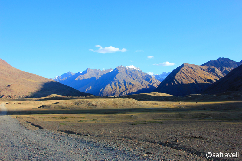
The Thungos Massif, 5805 m, and the view Westwards. More of the region at Flickr Photoset

A monk collecting water from Kanji nala. More info and pics of the region at Flickr Photoset
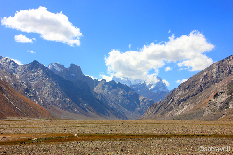
Past the Waka nala and the Gompa as well as the Kanji nala, the bumpy-road skirts the village Tashi Tongtse to continue the gradual climb to the pass. Here onwards to Padum, the population is chiefly Buddhists and accordingly the architecture changes. For the next 25km, the narrow gravelly-motorway passes through marmot country crossing the Paldar Tokpo as well as the camping grounds of Shuniz and Puchang that offer good pasturage interspersed with wild rhubarbs. Providing a natural habitat to the long-tailed marmots alongside the right bank of the Suru (or Ringdom Sankpo as known in this area), the stretch offers captivating views of Rangdum glacier, Chilung glacier, Pundum glacier as well as the Pensi Glacier, located on the left bank, just before the pass. Dominated by the Pk 6197 m (previously marked Pk 6050m Z8), the Pensi Glacier is also the source of the Suru River.

Village Tashi Tongtse in the Paldar Tokpo valley. More from the region at Flickr Photoset

Locally called Phiya, the threatened Long-tailed Marmot. For more pics of the region, please visit Flickr Photoset

Climbing the Pensi La by Ringdom Sankpo. Pk 6274 m in the Lalung Valley in sight. More pics at Flickr Photoset
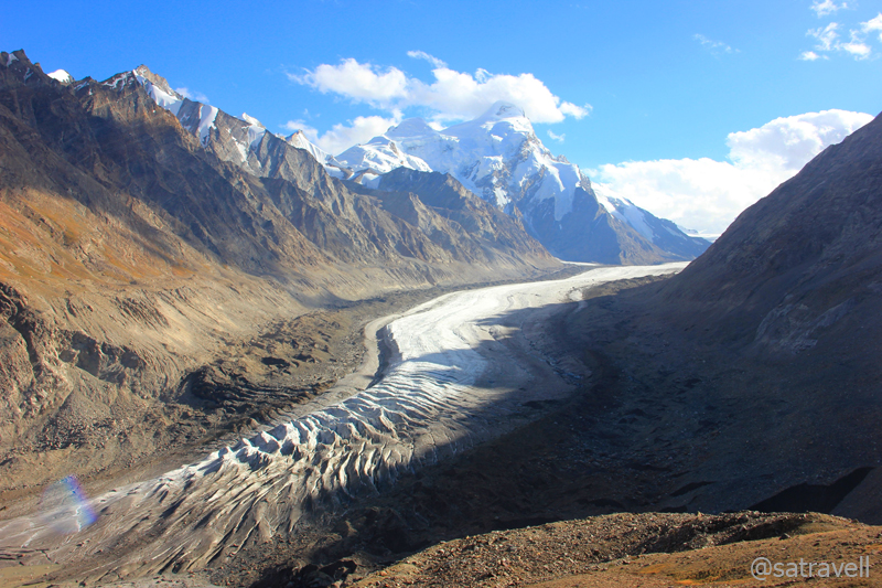
From Rangdum, we took almost an hour and a half to reach the Gateway to Zanskar, the Pensi La top at 4440m, offering the only motorable access to Padum, the administrative headquarters of the Zanskar valley. The landscape from the pass comprises fascinating views of snow-capped mountains on both sides. Past the shrine, just before the pass-top near a watch-tower, lays a couple of glacial lakelets – Sta Tso and Lang Tso. The top of the pass is marked by an information-board with prayer flags tied all around. A couple of kilometres after the information-board, to the eastern flank of the pass is the prized natural-formation – the majestic Darung Drung Glacier. With the Peak 6485 m Darung Drung (earlier marked as Pk 6270m Z3/ Cima Italia), located adjacently, the Darung Drung glacier is a long winding river of snow and ice sliding from the western slopes of the Doda peak (6550m).

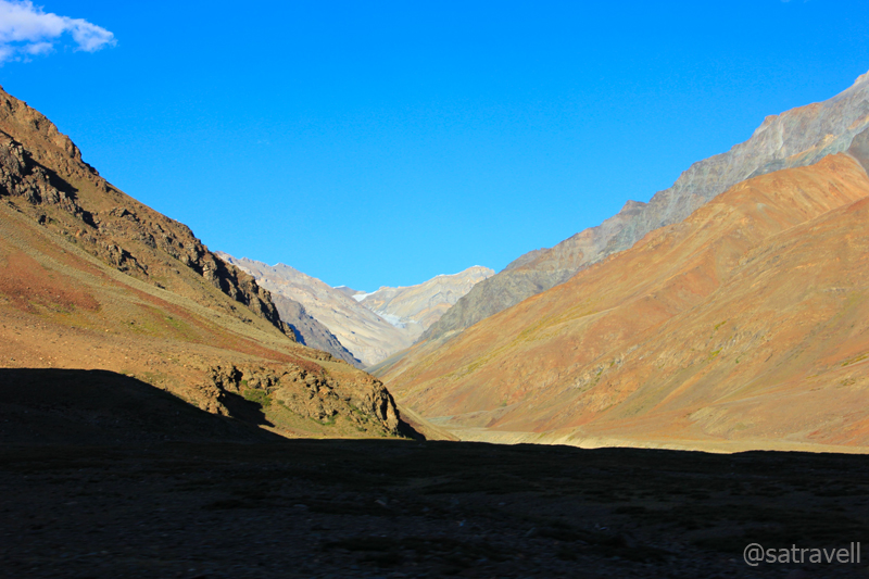
Landscape towards Rangdum. More at Flickr

Pk 6197 m on Pensilungpa-Darung Drung Glacier divide. More pics and info of the region at Flickr Photoset

Pk 6485 m Darung Drung. “As per the latest nomenclature adopted by the Survey of India” – Harish Kapadia. More peaks, pics and information at Flickr Photoset dedicated to the region
The sliding Darung Drung in Zanskar Region; Pk 5909 m on its Eastern wall. More pics and info at Flickr Photoset

The Darung Drung Glacier and Pk Aiseo 6029 m at its head; Pk Rahamo (6000 m) towards right. More of the glacier, surrounding peaks and the region at Flickr Photoset
It may be of interest to note that peaks in Zanskar near Nun-Kun, located within the periphery of the Darung Drung Glacier are numbered with a prefix Z. However, the Survey of India (SOI) has recently published an update to this; marking many of the formations. The 23km-lengthy glacier, likely to be the second largest glacier within India, is the source of 79 km-long Stod River or Doda River. The northern flanks of the Doda peak gives rise to the Haskira Glacier while its eastern slopes join the Kange Glacier. Mesmerised by the charm of the glacier and the peaks surrounding it, we spent almost an hour, amidst the typical afternoon high-velocity icy-winds, in trying to observe the visible formations around it.
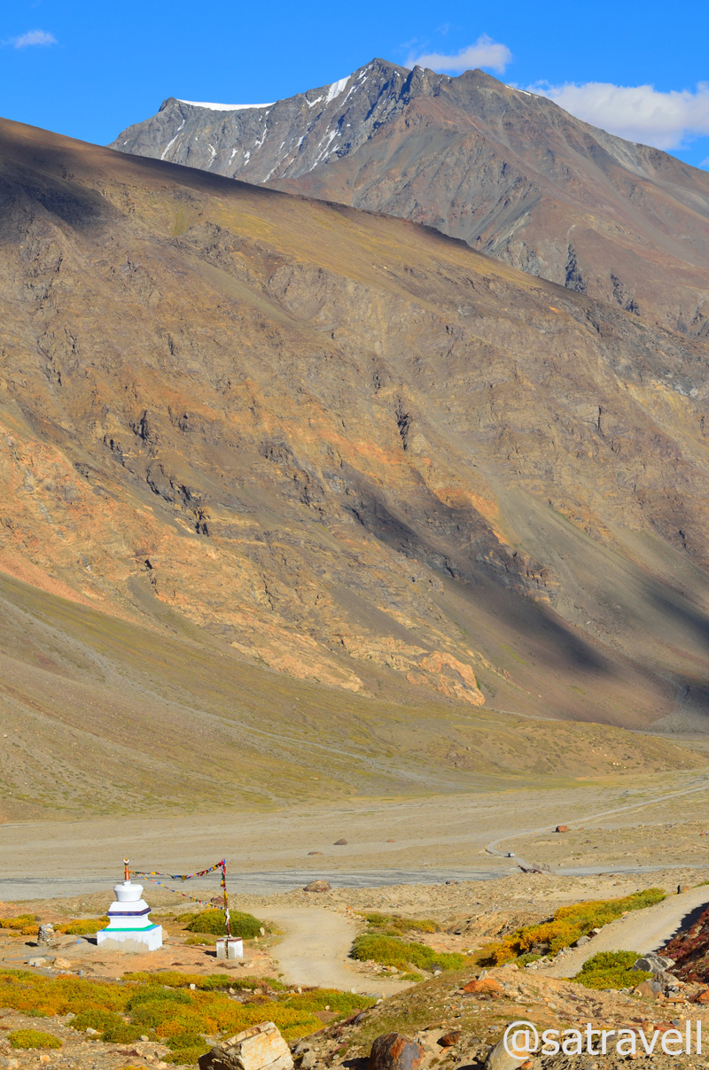
Into the Stod Valley from the Pensi La
Winding in hairpins and switchbacks, the rocky descent from the Pensi La into the Stod Valley is steeper than the climb up from Rangdum. Past an azure glacial-lakelet, the motorway meanders through a wider section of the Stod valley alongside the left bank of the Stod River. The famed Boyo Comma camping grounds appear after crossing the Pholokiow nala and the village Trakkur appear just before Chanu Tokpo that later joins the Stod.

The famed Boyo Comma camping ground in the Stod Valley. For more pics and info, please visit Flickr Photoset
Ahead, drained by the Stod, the vegetation and irrigation-rich landscape appeared much similar to Kaza-Losar section of the Spiti Valley. Tucked away from civilisation, it is a less-frequented valley surrounded by the Great Himalayan Range on the right bank and frontiers of the Zanskar Range on the left. Joined by small tributaries on both sides, the Stod meanders at its gentlest in this portion of the main valley. Consistently spread out villages outlined by vegetation along the alluvial banks walled by high mountains under fine blue sky establishes eternal bondage between a traveller and the creator. As many as 20 settlements lay interspersed on both sides of the river, connected by a pulley or foot bridge, till Padum. Comprising not more than 50 houses, the key settlements include Chibra, Abring, Hamling, Shagam, Phey, Ating, Tungri, Sani, etc. A few of these villages offered prime facilities, allowed by the terrain, such as guesthouses, teashops, STD booth, etc. Without a single stoppage on the way, we reached Padum from the pass in almost five hours covering a distance of 85km.
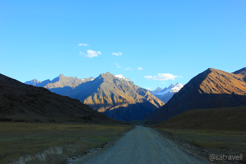
The motorway ahead in the Stod Valley. More pics and info of the region at Flickr Photoset
Although, the road-condition was a notch better than Kargil-Rangdum section, it offered many fresh perspectives to be captured most of which, due to fading light, I identified for the return journey. The motor-trail passed through some of the agriculture as well as pasture-rich greener sections of the Stod valley. The cultivated fields intermingled with a uniform carpet of red-shaded green vegetation dotted with ancient chortens, prayer wheels, flags as well as sheep, goats, yaks and further afield, wild horses; striking mountain faces in myriad hues; snow-covered peaks pushing up into cloudless blue skies; blackened moving snow fields and hanging glaciers; all combine to leave an eternal imagery on the mind. The villagers seemed to be occupied in preparing themselves for the long and dreadful winter season. The key tasks included collecting fodder to support the livestock, fuel and grains to support the family as well as collecting the red-turned alfalfa grass to provide thick insulation from snow on rooftops of their stone-built houses.
Landscape ahead; captured near Chim Kurpo. For more pics and info of the region, please visit Flickr Photoset
Driving alongside the left bank of the river till the Tungri iron-bridge to crossover to the right bank and reach Padum, as many as 14 rivulets rising from the slopes of the Zanskar Range that join the Stod River, needed to be forded with or without bridge. A few energetic ones are Pholokiow nala, just after the pass; Chanu Tokpo, after the Trakkur village; Kyala nala after Phey village; and Tungri Tokpo before Tungri village. Key tributaries on the right bank of the river are Kange Tokpo, Hangshu nala, Denyal Tokpo, Mulung Tokpo as well as Haptal Tokpo. Important natural-formations on the right bank include Haskira Glacier, best-viewed from Chim Kurpo fields; Kange Glacier, best-observed from Tepuk camping grounds; Hangshu Glacier from village Chibra, etc.
Shadow game on the Zanskar Range; near Tepuk. For more pics and info, please visit Flickr Photoset
Just 15km before Padum, after crossing the Tungri iron-bridge over the river, tarmac again showed up (3640m) after which we pressed on the accelerator to gradually climb to Padum. It was around 2100hrs when we reached the headquarters of the Zanskar Valley at 3670m. Most of the shops, restaurants as well as guesthouses were closed so without taking any risk we opted to settle in at the very first accommodation that we came across. Marking the onset of winters, mid-September, an off-season with respect to travelling in Zanskar meant limited facilities at disposal for residents by the guesthouses. Even though, a hectic day on road merited a well-deserved night still we settled for a rajma-subzi-chawal-roti menu. We intended to travel around the Padum area tomorrow and turn back for Kargil over the morrow.
Snow-capped spires of the Great Himalayan Range; near Aksho. For more pics and info, please visit Flickr Photoset

Sundown in the Stod/ Doda Valley; captured near Tepuk. For more pics and info, please visit Flickr Photoset
View and read more on the area at the Zanskar Region Photoset on Flickr
You may also like to subscribe to the email updates, of the remaining chapters, by entering your email id in the sidebar.


Pingback: Driving alongside Glaciers in Copper Land | bNomadic
Pingback: On Road through the trans-Himalayan Region | bNomadic
Thanks for stopping by at my blog. All the pictures are so amazing
Thanks Swati. Keep visiting (and encouraging)!
Yet another amazing piece…So much to see, feel and experience in this country !! I feel ever so blessed to be in India.
Thanks Sangeeta. India will always be the first love. Even from travelling point of view. Although, I would say that traditionally, we were not good travellers. 🙂
Very nice blog and exquisite information. I am looking forward for more interesting topics. Thanks.
Thanks Neelam for dropping by! I appreciate your feedback and would try to write even more interesting topics. Hope you’d enjoy the journey. 🙂
Asusual amazing place beautifully captured… Loved the shot of the temple and flags…
Thanks brother. I am glad you liked the perspective. Hope you found the contents useful too.
amazing pictures
Thanks. 🙂
The Phiya thing was unknown to me … thanks for introducing the cute animal 🙂
Thanks brother. Phiya is a lovely creature. Unfortunately faces extinction due to habitat loss.
who knows sooner even humans become history .. its horrible to know species fighting for existence
Sad indeed. Approximately 200 species die off every day. Now imagine that!
thats really sad !!
Love the landscapes
Thanks Nona for stopping by! I am glad you liked the terrain. Keep visiting.
Mesmerising landscapes captured beautifully.
http://rajniranjandas.blogspot.com
Thanks Niranjan. Hope you’d want to visit again.
Nice post. Very well written and informative. Good to know SOI nomenclature process.
-Vikas
Thanks for visiting my page Vikas and for showering it with appreciation. Hope you’d find the content useful too. Keep visiting.
Woow is the only word left !
Thanks Aziz Bhai.
Pingback: Butter Tea at the ancient Karsha Gompa | bNomadic