 bNomadic

A recently installed statue of Buddha overlooks the temple courtyard at Kamru
As I began to recollect my experiences based on my visits to the spectacularly beautiful Baspa Valley, I felt that a wholesome travel-post on this activity-rich area would warrant a longish description. To make the reading more meaningful, I now plan to introduce a hiking section on bNomadic so as to relate my trekking escapades and other adventures from this as well as other regions. The ensuing post talks about the travel wealth of the Baspa.

“This is the most romantic of the Himalayan valleys” Please visit Flickr for more images of the region
The Baspa Valley, also called Sangla Valley, conjures up images of the enormity of mountain ranges, comforting views, the richness of culture, forested faces higher up, agile fauna as well as friendly faces. The moment one takes the diversion along the Baspa River from Karcham, located at a distance of about 50 km from Rampur, on the dusty NH22 (formerly called Hindustan – Tibet Road) in the Satluj Valley, the magical spectacle of Baspa Valley begins to unfold itself. The calm Baspa River cleaving the gorgeous carpet of subalpine vegetation flanked by Dhauladhars to its left and Kinner Kailash range to its right, exhibits a spectacle which only comes closest to the place where God lives.
About 90km in length, the river happens to be the second largest tributary to mighty Satluj in Kinnaur. The road, 42km in length, connecting various settlements of the valley lies on its true right bank all the way up to village Chitkul, located at the other end. For the initial 18 km skirting Rutrang till the wide expanse of Sangla, the administrative headquarters of Baspa Valley, the road is narrow and treacherous in parts. As we inch ahead deeper into the valley from Karcham, the river Baspa adorns its calmer look. Legend has it that the race between Baspa and Satluj to reach Karcham first was responsible for the ferocity, now absorbed by the reservoir of power project, of Baspa downstream as it prepares to merge into the mighty Satluj. The myth is also related to the curious absence of chilgoza pines from the forests of Baspa valley.
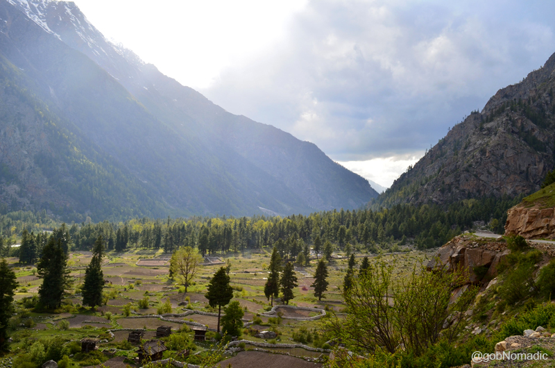
The fertile valley bed is neatly laid out in fields of peas, beans, turnips as well as finest quality of potatoes

The western ousters of Pk Raldang. Please visit Flickr Photoset for more images of the region
Past the last bit of live slide area on the motorway, the hydroelectric power project of Sangla comes into view. With the main village of the valley, Sangla (2650m) spread on the right bank of Baspa, the valley region ahead acquires the shape of a bowl. It is believed that this part of the valley was once a sheet of water and from the general geological evidences present nearby, one would tend to believe it. The river gently meanders along in an expanded bed of sand and pebbles creating numerous channels. The terrain here is neatly laid out in fields and gardens of peas, beans, turnips, finest quality of potatoes as well as dotted with rural cottages. There are plentiful shaded groves of apricots, the recently introduced varieties of apples as well as walnuts that bless with a cool retreat.
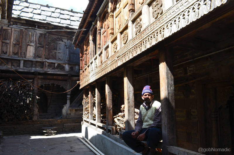
The courtyard of a traditionally kept house at Kamru. Notice the woodwork which is practiced in Kinnaur.
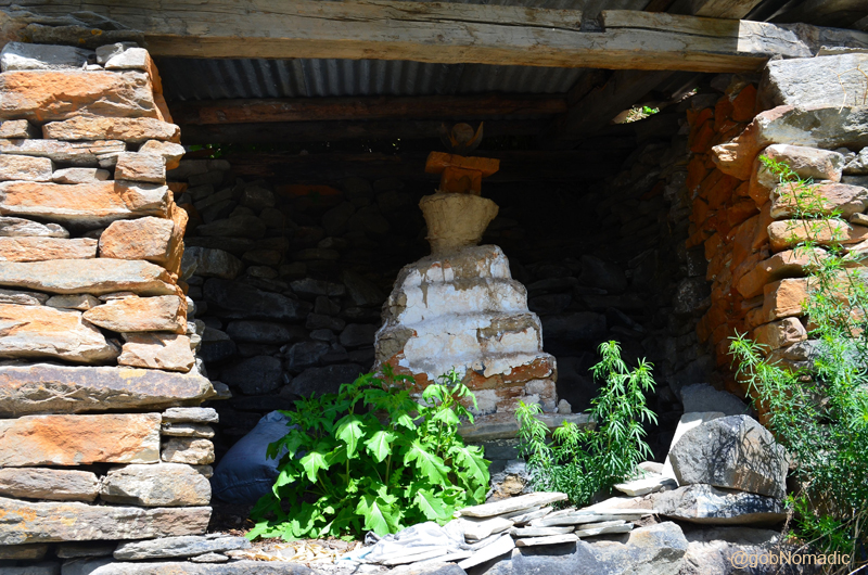
A roofed chorten spotted at Kamru. Please visit Flickr Photoset for more images of the region
Ever since the government had allowed visitors to Kinnaur, the area has been witnessing a continuous increase in travellers and tourists influx. From a village of not more than 50 families during the trade-route days, today, Sangla is fast bracing itself to cater to the needs of “touristy brigade”. Owing to its proximity to both Tibet (via Satluj Valley) and the “terrain of Hindu Gods” Garhwal (over the high passes), Sangla retains best of both worlds. Sangla used to be a meeting place for traders from Garhwal and Tibet. During those times, owing to the treacherous terrain of the HT road, the Baspa Valley used to be the preferred diversion for both travellers and traders to enter Kinnaur part of the Satluj Valley to reach Shipki La. The then Vicerine of British India, Lady Canning crossed the Dhauladhars through Rupin pass in 1860 to reach Kalpa.
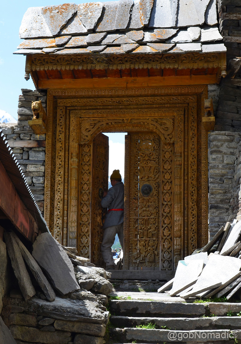
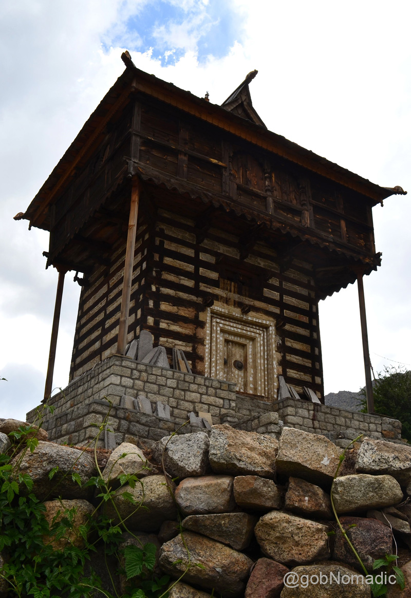
The intricately carved entrance door to the Kamru Fort
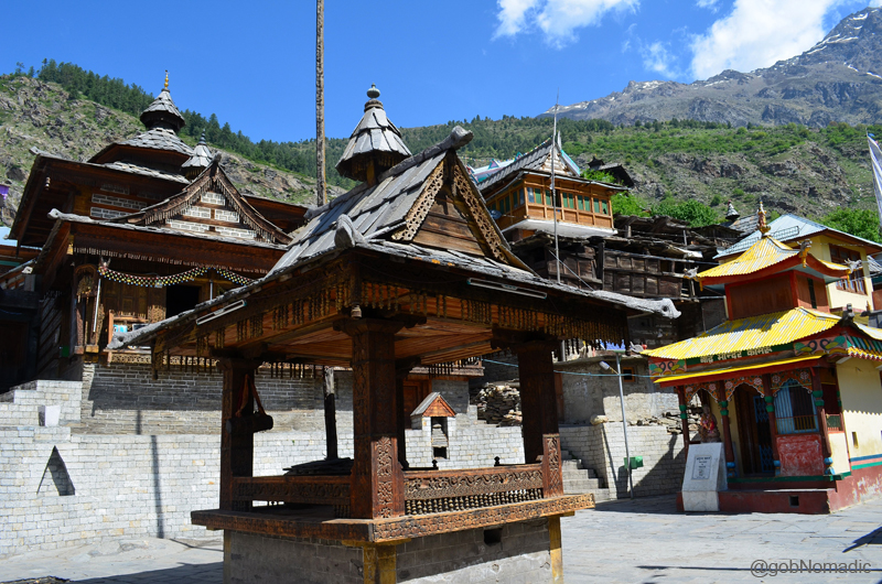
The Kamru (formerly called Mone) temple complex. The recently built Drugpa Monastery is also in the frame.

“Even after the Bushahr capital was shifted to Sarahan and Rampur, the enthronement ceremony continued to be performed at the impressive fort of Kamru (Mone)“. The fort also has an enclosure with a deep well, in which, it is claimed, criminals were kept. Please visit Flickr Photoset for more images of the region.

Ancient temples within the compound of the Kamru Fort. The olden temple was built by a Bushahr King after his forces had successfully withstood an attack by Tibetan chieftains. More images at Flickr Photoset
Streaked with snow, the immense western clusters of the Raldang peak towering above the settlement of Sangla, reminds one of his presence in the vicinity of the colossal Himalaya. Looking up the slope one would notice the spread of the settlement of village Kamru located obliquely above Sangla. Commanding a wider view of the valley, Kamru (2770m) is home to the most striking monument of the Baspa Valley – the Fort of Kamru Narayan. The pathway to the Fort-cum-temple complex of Kamru branches off the valley road near the PWD facility at Sangla. Although, the complex was said to have been recently renovated, entry inside the Fort was still not allowed owing to its dilapidated state. Past the superbly carved main entrance, the tiled courtyard houses an ancient shrine devoted to Kamakhya Devi, the Durga’s incarnation in Assam as well as a small Buddhist temple. The presence of olden mani walls and chortens in the settlements of Sangla confirms the decided presence of Buddhism, along with Hinduism, in the valley. The presiding deity of Sangla is Nag Devta.

A section of the valley bed as observed near village Batseri. Please visit Flickr Photoset for more pics
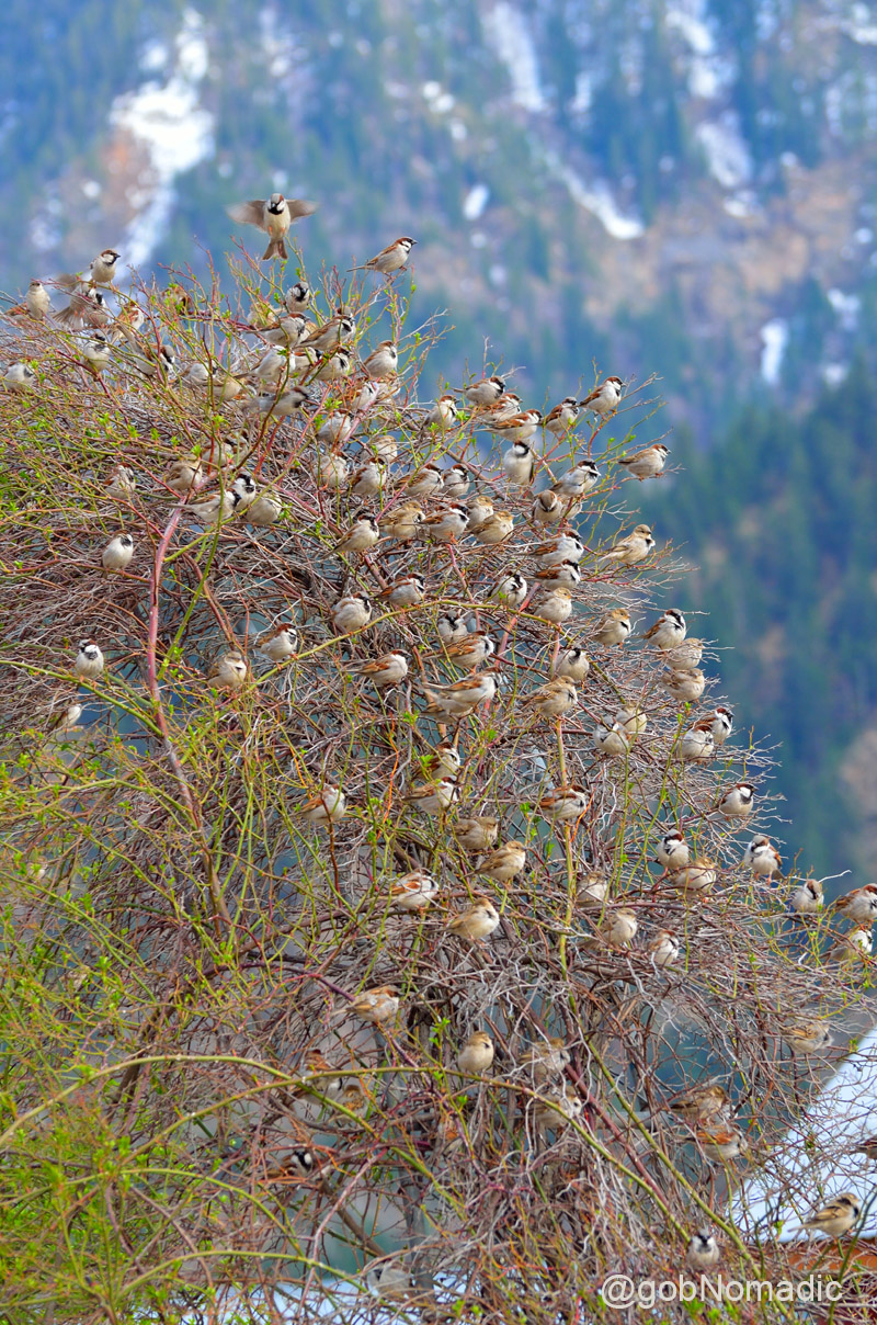
House Sparrow “Tree” at Sangla
The portion of the valley from Kamru right up to the fields of Chitkul at the other end of the motorable road retains some of the most memorable Himalayan sights. The road passes through Rakcham (3115m), 12 km further up from Sangla, and Chitkul located at a distance of 12 km towards the head of the valley. The Baspa here rolls smoothly on pebbles with a gentle murmur, or rushes with rapidity in a narrow stream creating tiny islands full of wild berries, surrounded by blue pines, willows, hazel and sweet briar, etc.

The last bit of stretch; a few km before Chitkul. More images from the region at Flickr Photoset

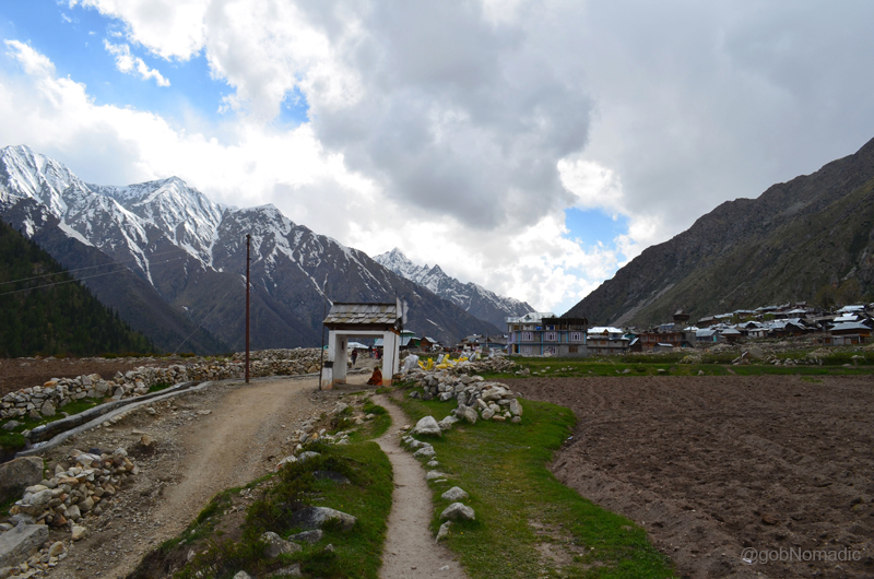
Village Chitkul in sight. More images from the region at Flickr Photoset
The village Chitkul (3450m) is the last and the highest village in the valley. Owing to the increasing tourist activities, a few guesthouses and hotels have now sprung up in this otherwise a sleepy village. The village houses an olden temple complex dedicated to Mathi Devi, its presiding deity, said to be a consort of Kamru Narayan. The view from the village would remind one of trans-Himalayan mountain-scape. The verdant cultivation, or now and then scantily wooded with a few stunted pines, is strongly contrasted with the barren faces of rugged rocks on either hand which present naked and impracticable crags frowning in a terrific forms.
The settlement of village Chitkul. Please visit Flickr Photoset for more images of the region

The view from the village Chitkul reminds one of trans-Himalayan mountain-scape. More images at Flickr

Sarabjit showing results of his camera to the local kids
Part of the Mathi Devi temple complex, the Bara Qila at Chitkul. The temple is said to be over 500 years old.
The grandeur of the mountain-scape offers fresh perspectives on the return journey as well. Impressed by its richness, Capt Gerard, one of the first to record a visit to Kinnaur, wrote in his book Account of Kunawoor, “this is the most romantic of the Himalayan valleys and it is difficult to imagine a more beautiful spot”. Later logs have been equally full of praise about the beauty and magnanimity of this valley.
Not only for its sheer beauty, the Baspa Valley is known for its skilled wood and metal craftsmen. Apart from fruit and veggies, the valley is also popular for trout farming, particularly near the flat valley bed around village Batseri. In terms of travel lure, Sangla valley is a paradise for Himalayan lovers and photoartists as well as trekkers. The most popular of all trails is the day hike up to Sangla village pastures known by Sangla Kanda. Another popular hike is the easy walk up to Nagasthi, the last Indian outpost in the valley towards border. The valley also happens to be on the route of Kinner Kailash parikarma. For the expert ones, the most popular option is Chitkul to Har-ki-doon or Harsil trek. A few frequented passes around Sangla valley are Charang, Rupin, Khimloga, Lamkhaga, Borasu, etc. Foreigners would, however, require permissions from the concerned authorities to crossover a few of these passes.

A female Siberian Stonechat. Please visit bird gallery at Flickr Photoset

Blue pines by Shushang Nala in the Mostrang section
The valley offers ample accommodation avenues for backpackers or holidaymakers. However, my favourite would remain the PWD or the furnished HPSEB guesthouses. Built in 1908, the spacious British-era Forest RH is located amidst a thick forest across the river near Sangla. The preferred route from plains, to reach Sangla, would be Chandigarh – Shimla – Theog – Narkanda – Rampur – Jeori – Karcham – Sangla. Narkanda would be an ideal night-halt.
Average Altitude: 2800m
Best time to visit: Spring and autumn
Travel Lure: Landscape and wooded trails
Accommodation: Limited but usually available


Beautiful Photos! This place looks amazing.
Thanks for stopping by my blog. The place is far more beautiful than what I have been able to capture. Keep visiting bNomadic 🙂
I stayed at Rakcham, ahead of Sangla. There’s a solitary inn there. It is so heavenly, I want it to stay that way, and, paradoxically, dissuaded people from going there, demanding facilities, amenities, hotels, shops, plastic water bottles, electricity, internet. I actually hope Rakcham stays pure and simple, no-nonsense, no-frills place where only ppl like u n me would go to.
I even made the location the setting of one my stories in my book of short stories “One at a Time” (www.pravingandhi.com/one-at-a-time(. Do see the site, and if it entices you do get the book from one of the online stores mentioned (Rs199 only). The story based in Rakcham is my favourite of the lot.
I was actually going to Kaza and took a diversionen-route to stay in the Baspa-Sangla valley.
Rakcham is indeed very beautiful section of the valley. Offers many options to unwind/ adventure/ hike. I wish to extend my stay there sometime for up to one full season. Great to have met you. Hope you’d want to visit bNomadic again. 🙂
This is such a wonderful place… Beautifully written 🙂
Thank you for visiting bNomadic and for showering it with appreciation. Hope you’d want to visit again.
Wonderful post! And awesome clicks! 🙂
Thanks:-)
nice post…the pics give good company to the content. Keep it up…
Thanks. Hope you’d want to visit again. 🙂
Baspa valley is SO beautiful! 🙂
O yes. One of the most beautiful. Thanks 🙂
Gorgeous pictures, and writing. Really enjoyed this post, thanks.
Thanks admin for dropping by my blog and for the appreciation. Hope you’d want to visit again. Keep visiting 🙂
This is amazingly detailed. Well photographed and well-written!
Thanks Mohit 🙂
Personally investigated by you, all of this?
😐
What? I didn’t get that!
Of course buddy, insofar as bNomadic, I am a one man army.
Kudos buddy! Great job!
Beautiful post…
Just loved the way you have presented the story with stunning images and very informative notes.
Thank you so much for sharing 🙂
Thanks Sreejith for stopping by my blog and showering it with appreciation. Hope you’d want to visit again. 🙂
Interesting post. I haven’t been to this area. Hopefully can drive down from Delhi in March/April.
O yes! Not only open but relatively free of tourists as well. Please keep visiting bNomadic for more. 🙂
Love this post, you write in such detail! Happy travels 🙂
Thanks admin for stopping by my blog and for the appreciation. Keep visiting bNomadic for more travels.
Great post. Amazing photos (I love looking at nice photos from around the world). Now following.
Thanks admin for dropping by my blog. Keep visiting for more travel stories. 🙂
Hi I have nominated you for the Very Inspiring Blogger Award. Thank you and keep inspiring. http://maverickbird.com/2014/12/18/i-am-touched/
🙂 Thanks. I’ll surely follow this post once I am home
wow!!
Keep visiting bNomadic 🙂
Wow…that’s a great post with fascinating photos. Wish to visit Kalpa and Kannaur someday
Thanks admin. You should definitely visit this valley. 🙂
Beautiful photos and nice thorough narrative.
Thanks Marc. Keep visiting bNomadic for more. 🙂
Cheers, will do…
Your photos are simply amazing and I’m pretty sure that the landscape in real life is equally amazing or more. I have been to Ladakh and the mountains took my breath away. There’s something about the Himalayan mountain range that not even the European Alps can provide that kind of admiration and awe.
Cheers,
Kat
Thanks for dropping by my blog Kat. I am glad you liked my post. The Himalaya are purely addictive. Keep visiting bNomadic for more travel stories related to the Himalaya. 🙂
Breathtaking pictures. This place looks amazing. Thank you for sharing.
Thanks admin for showering bNomadic with appreciation. Keep visiting for more 🙂
Beautiful 🙂
Thanks. Keep visiting bNomadic for more. 🙂
What a dream!
Absolutely true! Keep visiting bNomadic for more
so awesome!
Thanks for dropping by my blog. Keep visiting bNomadic for more. 🙂
Reblogged this on touchdownohio and commented:
Discover New Roads
Thanks. Keep visiting bNomadic. 🙂
beautiful photographs and writing.
Thanks admin for dropping by. Keep visiting bNomadic for more 🙂
How utterly refreshing! Thank you for sharing your ABOUT Author and your beautiful photos – so timely for me to see at this time and thank you for Liking my post!
Thanks admin for dropping by. I am glad you liked it. Keep visiting bNomadic for more travel stories. 🙂
Thank you for liking my post ‘Attracting what you require,’ I must require more travel as I glean through your photos and know I’ll ‘be off again! Thank you – they are all magnificent and so is the beautiful earth upon which we tread. Thank you again for your input.
Thanks. I am glad you liked my blog. Keep visiting 🙂
Incredibly beautiful scenes and depiction of culture. Wish we could visit here someday.
Thanks admin. This is truly one of the most beautiful valleys of the region. Keep visiting bNomadic for more…
Pingback: Mooning with the Highway to Tibet | bNomadic