 bNomadic
The following post is a part of the “Kailash Mansarovar Yatra” Blog Series Into the Sacred Space. To read complete travel memoirs and trip report, please visit here.
And so we set out once more on the road to the Sacred Space. Occupying rear seats in the bus, a few fellow travellers occasionally raised the holy cry Har Har Mahadeo and some others jingled from the middle. “Apart from giving me a wider view for snap recording, the first seat had its own advantage”, I chuckled at the thought. With the local police leading it, our small fleet of the buses along with the vehicles of STDC, ITBP, doctors and ambulance had taken the shape of a convoy.
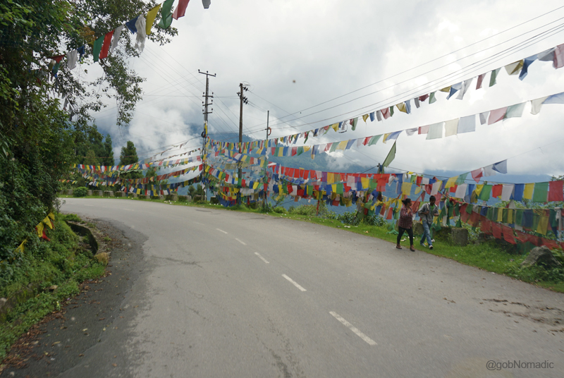
The initial stretch of the highway to Nathula. Please visit Flickr for more images of the region.
Our next stop was Fifteenth Mile (3200m), as measured out from Gangtok, a small village where in the olden times Tibet-bound travellers, traders along with their transport muleteers used to halt for the night. In fact, more than their native names, the villages on the Gangtok – Nathula highway, an erstwhile trade route artery, are known by their respective distances recorded in miles from the capital city of the state of Sikkim. Our cavalcade looped up the hill and we could distinctly spot the Gangtok settlement spread on densely wooded ridges and terracing towards the valley floor. The white stream of Rongni Chu sparkled far down in the valley.
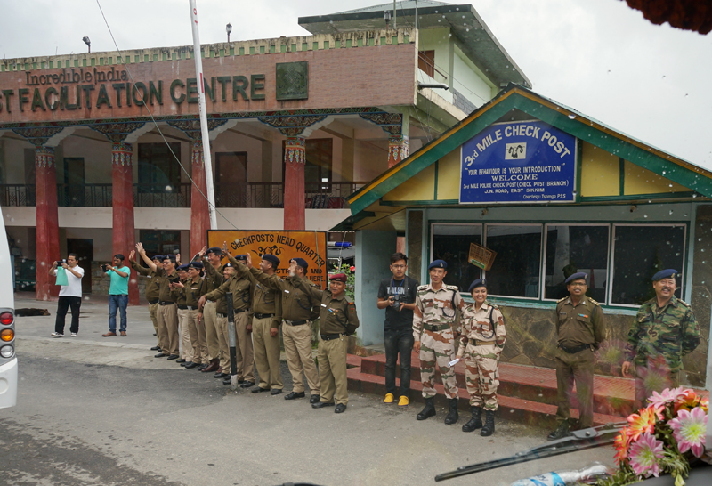
The highway Police and ITBP officers waving at us; at the Third Mile check-post. More at Flickr
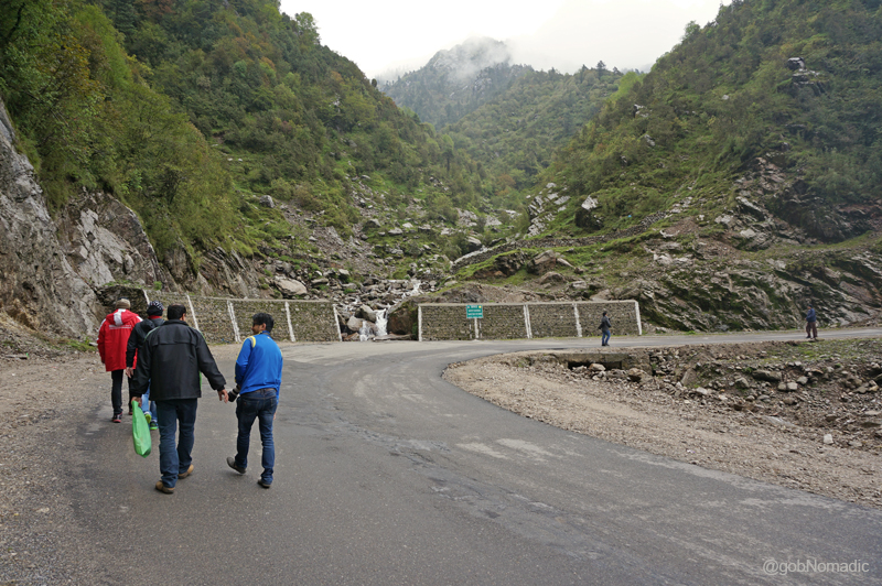
Slowly we inched ahead on a narrow stretch of the road which was notorious for landslides. With the BRO earthmovers parked regularly, the condition of the road reflected on the emergency situation that might arise just anytime during a rainy spell. Vishal, our sturdy Sikkimese driver, seemed to be a total professional with his job. When he was not manoeuvring the vehicle through treacherous patches, he would intelligently plug-in his pen drive to play either local or Bollywood songs only to be stopped later by someone from the passengers.

A narrow stretch of the highway ahead. Please visit Flickr Photoset for more images of the region

Sh Amitabha Sinha, senior lawyer at Supreme Court of India with the STDC support staff; our driver Vishal to his left (right of the frame). More images from the region at Flickr Photoset
Although the distance between Gangtok and Fifteenth Mile or Kyongnosla, its traditional name, is about 31 km but for the road conditions we took about couple of hours to cover the stretch. During the olden times, this stretch was at best a bridle trail comprising veranda bridges on sheer precipices. The valley here was open as well as stony.

Climbing steadily, we were subjected for the first time to the high-altitude experience which was to become integral part of our journey ahead. More images from the region at Flickr Photoset
By the time we reached the first acclimatisation centre at Kyongnosla, the weather had become overcast. As the clouds gathered in the valley began to move up, a slight drizzle came. The villagers and curious onlookers had gathered at the centre to welcome and offer us the cultural icon – khadas one by one. A lama from a local monastery had been invited to bless the travellers. We pushed ourselves inside the dining hall of the centre and ravenously began feasting on the hot soup and snacks before the lunch got served.

The fanfare at the Fifteenth Mile. Please visit Flickr Photoset for more images from the region
The locals according traditional welcome to the Kailash Mansarovar travellers. More at Flickr
Post lunch we were allotted our accommodations for the next two days. The newly built acclimatisation hutments comprise dormitories and some rooms. A few of us, mostly the younger ones, were allotted the second acclimatisation hut at the Seventeenth Mile (3250m). The first centre was situated adjacent to the main market of the village. The second centre located ahead is set in a more natural surrounding; away from the humdrum of the market. The occasional traffic movement we noticed comprised army vehicles or tourists, etc. who were mostly heading towards the pass. Down below, two streams merged into one adding splash of whitish water in otherwise a silent densely wooded valley. The next briefing was scheduled early evening at Fifteenth Mile that day. At the Seventeenth Mile, the fellow travellers went into slumber one by one. I took my camera gear and headed on the road towards the Fifteenth Mile. It was still misty and the visibility was very poor.
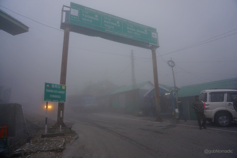
The acclimatisation centre at the Fifteenth Mile and the village market. More at Flickr

Lunching and snacking at the first acclimatisation centre on the Gangtok-Nathula highway. More at Flickr

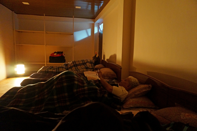
The accommodation at the Seventeenth Mile. Please visit Flickr for more images of the region
For the next two days taking walks between the two centres was to be the mainstay of the activities. The birdlife was abundant in the valley. With limited visibility for most of the time over the next two days, I was able to identify Blue Whistling Thrush, White-capped Water Redstart, Hill Pigeon, Raven, Doves, Babblers, etc. on the road. In between I would often sneak into the roadside tea-snack cafes at the Fifteenth Mile and update my travel-notes. I always feel that such spots managed by the natives provide you with a lot of first-hand information on the region. Most of such tin-roofed house-cum-shop structures were multi-natured store selling all basic supplies from basic winter accessories to tea, coffee, noodles, simple meals or even liquor and beers, etcetera.
For the next two days taking walks between the two centres was to be the mainstay of the activities.
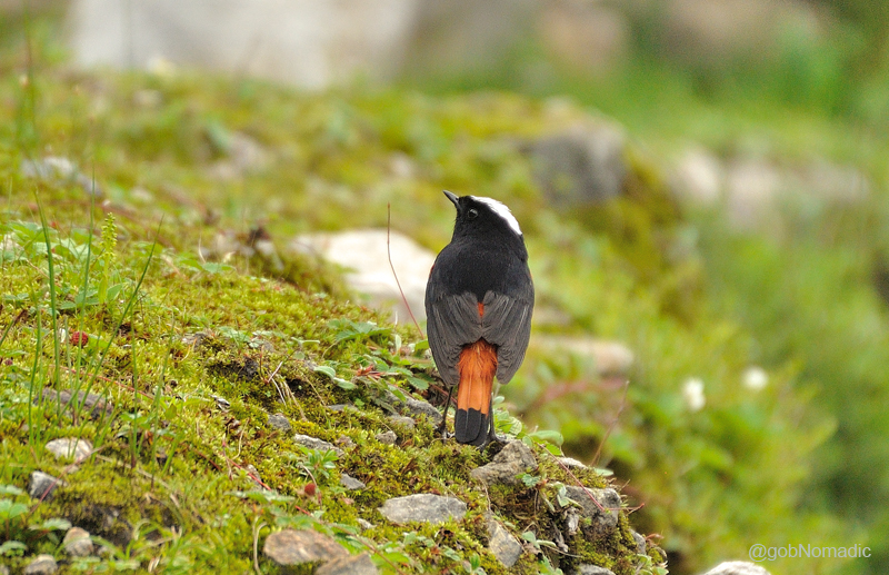
White-capped Redstart, a resident bird of the Himalayas. More bird images at Flickr Photoset
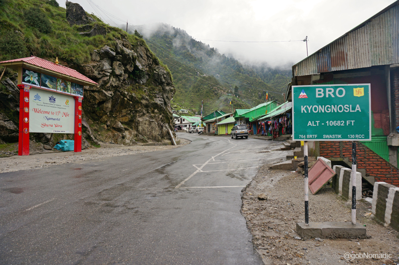
The road and the small market of Kyongnosla. More images from the region at Flickr

Most of such tin-roofed house-cum-shop structures were multi-natured store selling all basic supplies from basic winter accessories to tea, coffee, noodles, simple meals or even liquor and beers, etc.
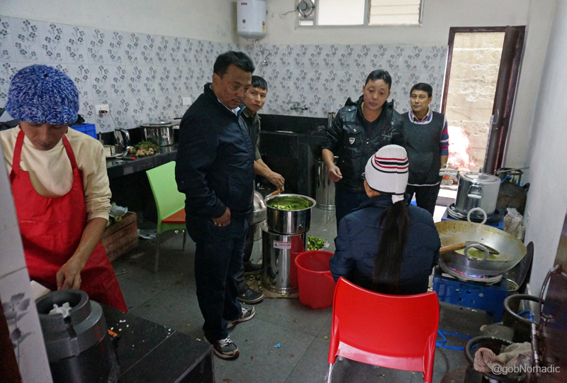
As if the previous briefings were not enough, we were briefed by a set of three doctors in the evening that day about the medical precautions we needed to take on the journey ahead. The worst outcome of such briefings was the questions and answers session that followed. My medicine kit comprised just the basic ones apart from the Diamox, the overestimated drug for high-altitude acclimatisation. I trusted just an extra amount of water intake plus a few cloves of garlic and ginger that I chomped daily in the morning. Dinners were usually a noisy affair; initially because of the briefings and later because of the culinarians. I was part of the foods committee of our batch and we held our first meeting with the cooks that evening. It was the STDC’s job to hire cooks for us. Being a first batch through this route, the STDC deemed it fit to allocate five seasoned “mountaineers” for our batch. Without getting into further details and trusting their experience, the in charge of the committee gave them some cash to buy rations, vegetables, fruits, etc. for the journey ahead.

The Foods Committee meeting with the cooks (mountaineers) in progress. More from the region at Flickr
Meanwhile inside the kitchen. More from the region and the journey at Flickr Photoset
Chaturvedi Ji busy chatting with someone at home. This was the last point on the India side with mobile connectivity (mostly BSNL)
Call it the benefits or drawbacks of staying in a group, that evening I slept at around 9:30pm (actually!) and completed my seven hours sleeping cycle way before the daylight broke the next day. It was still drizzling when I got up the next day. The pitter-patter of the rain outside and on the tinned-roof was musical as I lazily snuggled in my warm beddings. Soon after everyone got up and as the weather eased later, we strolled downwards towards the first centre. At breakfast it was announced that if the weather remains stable we could go visit the Tsomgo (Changu) Tso. The idea of visiting the high-altitude Changu Lake (3800m) appealed to everyone as it would further expose the group to even higher altitude and help in acclimatisation. Someone from the group expressed, “Whatever be the weather, let’s just go!” I headed back to the second centre after the morning meal.
Misty outside with almost zero visibility. More images from the region at Flickr Photoset
One of the forest outposts to the Kyangnosla Alpine Sanctuary – home to the Red Panda, the state animal and the Blood Pheasant, the state bird; apart from a whole lot of invaluable flora – was located just above the hutment of the Seventeenth Mile. I expressed my desire to trek inside the sanctuary to the STDC guys around and sought permissions from the forest department through them. They confirmed but said, “Only if the weather improves”. The pine-clad wooded and boulder strewn mountain-faces were a riot of Himalayan colours; shades and hues of greens and blues; overhead a turquoise sky with a massive grey cloud rolling northwards, sideways were the greens of the Kyangnosla forests and far below the waters of the Lungtse Chu meandering like an angry serpent. Back at the dormitory, I tried to read Charles Allen’s A Mountain in Tibet, the only book I carried but, instead, I slothfully lied down on my bed and listened to Karunesh.

View towards the Nathula side from Seventeenth Mile. More images of the region at Flickr Photoset
A few hours later, an azure mist was rising far in the distance marking the onset of the afternoon cloud as I decided to head towards the Fifteenth Mile once again where the schedule to visit the Changu Lake was already announced. “The only downside of the expedition as observed so far,” I thought, “has been that it was an organised one”. A few of the group members opted to remain at the centre. The bus took nearly 30 min to reach the Lake. The road, wider now, loops to reach the Lake passing a small marketplace on the way. We clambered over the small check dam and found a green water body stretching for almost half a kilometre before us in the shape of a large bowl surrounded by barren mountain faces. The road to the Nathula lay by the edge of the lake. A grey boulder at the lakeside marked the Twentieth Milestone from Gangtok.
The Changu Lake as viewed from the east end. The road to Nathula is also visible in the frame. More images of the region at Flickr Photoset

Professor Emeritus Kiran Seth, IIT Delhi and co-founder of SPIC MACAY taking a walk by the Lake
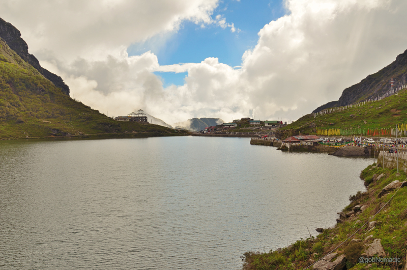
The Tsomgo Tso or Changu Lake is also the origin of Lungtse River. Please visit Flickr Photoset for more
Vegetation was now beginning to cease. I took a stroll around the possible edges of the lake and spotted a family of Ruddy Shelduck along with their ducklings. It is claimed that local lamas could forecast the weather and future by observing the colour of the water of the lake. There was a shrine dedicated to the Lord Shiva as well at the lake.

The purple-veined Cobra Lily with a snake’s tongue-like appendage resembles a striking Cobra snake.
The doctors had advised us not to overexert at the lake and the falling light and visibility rendered the photo-recording quite useless. In about a couple of hours’ time, we were on our way back to the 15th Mile where yet another mega briefing session awaited us (Phew!). The evening was spent in collecting notes, taking snap records and once at the room after dinner: sorting out luggage for the next destination.
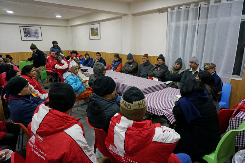
The mammoth briefing meet at the Fifteenth Mile. More images from the region at Flickr Photoset


Pingback: Reception at Gangtok | bNomadic
Pingback: Into the Sacred Space | bNomadic
bNomadic Nathula is a lovely place to visit. I also visit over there…but after focusing on this post my experience is not better then to you… You have described well here..
Great Work bNomadic Keep it up!!
Thanks
Thanks great admin. I am glad you liked this post. The actual crossover through Nathula is yet to be written and posted here. Watch this space! :-). Also, look forward to visiting DNP sometime soon.
Those roads look a little scary! Great to read the birdlife was abundant. I would have enjoyed that aspect. I’m more of a solitary person so probably wouldn’t have coped so well with the group conditions. The scenery looks really interesting and certainly the culture seems different to what I have in my own country. Thanks for sharing. 🙂
Thanks for stopping by the blog Jane. I’d say that most nature/ wildlife/ birdlife lovers are solitary persons; at least when it comes to outdoors. Sikkim is a beautiful region in the Himalayas with abundant birdlife. More on this soon on the blog. Keep visiting bNomadic for more such stories from the Himalayas 🙂
White-capped Redstart bird is beautiful. Cobra Lily does look like a cobra. Nice capture.:)
Thanks Kashpals for the encouragement and appreciation. Keep visiting 🙂
The photos are beautiful!
Thanks 🙂
Wonderful write up and excellent shots.The purple-veined Cobra Lily with a snake’s tongue looks like a real cobra.Thanks a lot for the detailed write up.
Nominated you for the Liebster award.:)
Cheers,
Sriram & Krithiga
http://www.srikri.com
Thanks SriKri for being a great support. Keep visiting bNomadic and showering it with appreciation and feedback. 🙂
Beautiful blog and nice photos…….
Thanks admin for stopping by the blog. Keep visiting bNomadic for more such stories 🙂
Thanks for liking my blog post. You have a very nice blog yourself…keep up the great work!
Thanks! Keep visiting bNomadic 🙂
Pingback: The Legend of Soldier Saint Baba Harbhajan Ji | bNomadic
Pingback: The Legend of Soldier Saint Baba Harbhajan Ji
Excellent description and eye for detail. Thanks.
Thanks for stopping by the blog. Keep visiting bNomadic 🙂