 bNomadic
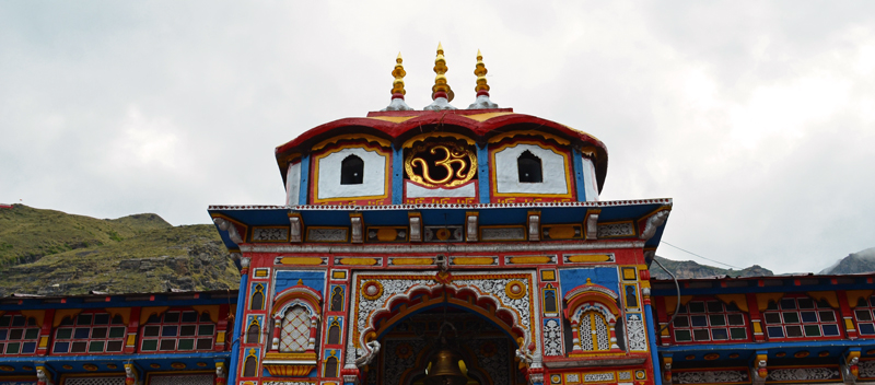
No other river has stimulated man`s imagination in India like the Ganga. Devotionally called Gangamaiyya or Maa Ganga, the river occupies the status of mother Goddess in virtually all Hindu homes. Descending from the icy heights of Gaumukh glacier in the Central Himalayas, the sacred Ganga enters the plains at Haridwar and flows through the great plains of north India before it finally arrives in the Bay of Bengal after completing a journey of over 2,500 km. The third largest river in the world by discharge, the Ganga, unfortunately, also ranks among the most polluted rivers of the world.
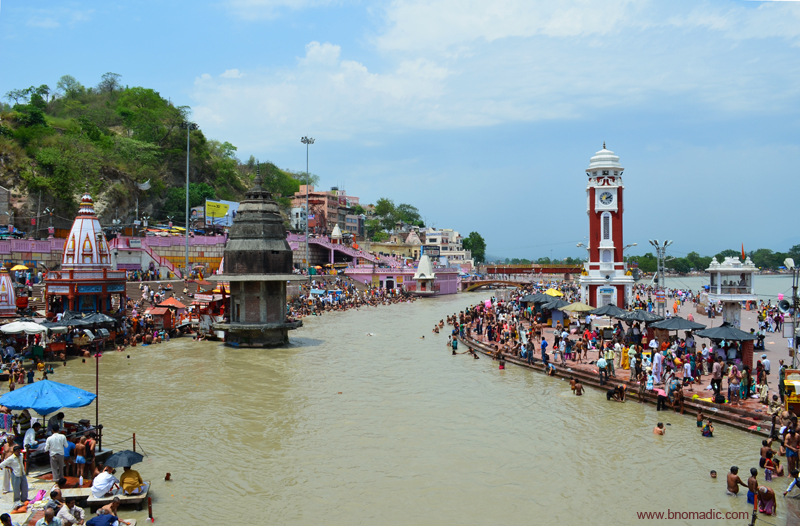
Located by the rightmost channel, just as the Ganga enters plains at Haridwar, the famed Ghats – Har Ki Pauri – literally meaning steps of Lord Shiva, are believed to have been built by the King Vikramaditya in the first century BC. Haridwar also marks the start of the Himalayan Char Dham Yatra. More images at Flickr
A few weekends before, courtesy the CEAT Tyres, I got an opportunity to road travel along the River Alaknanda, one of the two popular headstreams of the Ganga that originates in the Badrinath region. Such is the reverence for the Ganga that the greatest of all Himalayan temples for Hindus, Char Dhams – Yamunotri, Gangotri, Kedarnath and Badrinath – are located right at the source of its four major headwaters Yamuna, Bhaghirathi, Mandakini and Alaknanda. It is believed that anyone who completes a pilgrimage of the four dhams assures himself a place in the heaven. Revered since time immemorial, the Badrinath has gradually become the cornerstone of this pilgrimage.

Strawberries on display by the highway; you could halt to give your taste-buds the fruity touch. Photo by Sarabjit Lehal

A group of pilgrims from Rajasthan at the Triveni Ghat, Rishikesh. Photo by Sarabjit Lehal
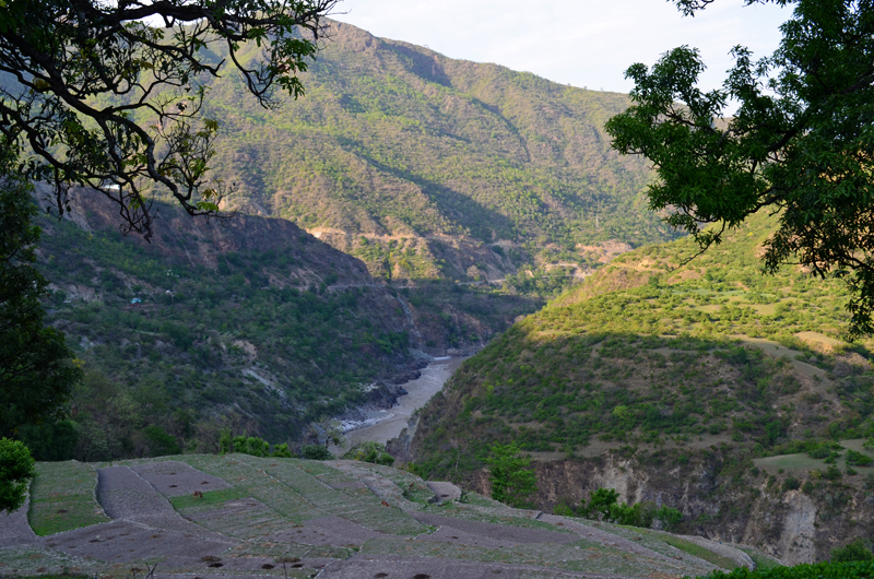
After a sumptuous breakfast at our hideout in Rishikesh (370m), gateway to Garhwal – home to the Ganga headwaters – we started our upstream drive along the Ganga. Passing through the important adventure spots of Kaudiyala and Shivpuri, a fairly broad road curves along fragile hillsides on the right bank of the Ganga. In just above 70km from Rishikesh, the road reaches a maximum of about 1200m near the landslide zone before descending to Devprayag, spread at an average height of 800m. Going upstream, Devprayag is the first and the most important of the panch prayags, the five sacred confluences of glacial streams with the Alaknanda River in the Himalayan state of Uttarakhand. Together they are called the panch prayags: Devprayag, Rudraprayag, Karnaprayag, Nandaprayag and Vishnuprayag in that order upstream.
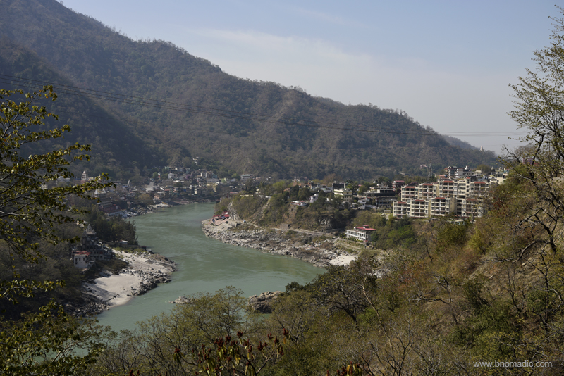
The Ganga preparing to enter the settlement of Rishikesh. Photo by Sarabjit Lehal

With the turbulent Bhaghirathi dropping in from left and calmer Alaknanda from right, the Ganga prepares to leave the mountains. Photo by Sarabjit Lehal
Otherwise a sleepy small town visited mostly by travellers or pilgrims, Devprayag attains popularity because it is here that the mighty river Ganga attains its name after confluence of Bhaghirathi and Alaknanda. Right from the highway high above the confluence, one could see stepped ghats below the small settlement leading to the icy waters. It was spring, so the waters were bluish-green and relatively calmer otherwise gushing in from the north-west the Bhagirathi is usually turbulent, whereas, pitching in from east the Alaknanda carries volume with it.
Meeting with her turbulent consort, the Alaknanda hurries down as she unites her clamours with the blustering current of Bhagirathi. Devprayag has always been a preferred halt for pilgrims on way to complete their Char Dham Yatra. The town also happens to be the winter home of the famed pandas of the Badrinath shrine. The Badrinath priests, mostly Brahmins from south India, had settled here in the eighth century when they accompanied the Hindu saint Adiguru Shankaracharya to the Badrikashram.
The highway from Rishikesh to Badrinath (Mana) is part of the NH58 that further connects it with Ghaziabad near New Delhi. The road ahead, slightly raised along the valley floor, meanders more or less along the Alaknanda. Being on the prime pilgrim network, the entire route is full of road side dhabas, sufficiently spaced fuel pumps and hotels. The next major town is Srinagar (580m), the erstwhile capital of the Garhwal Kingdom.
View from a roadside eatery ahead of Devprayag. Please visit Flickr for more images of the region
The Alaknanda! Please check Flickr for more images of the region
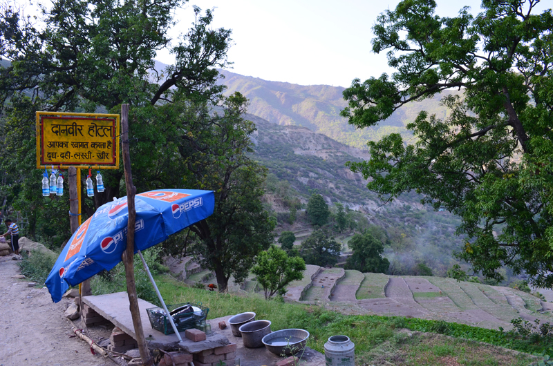
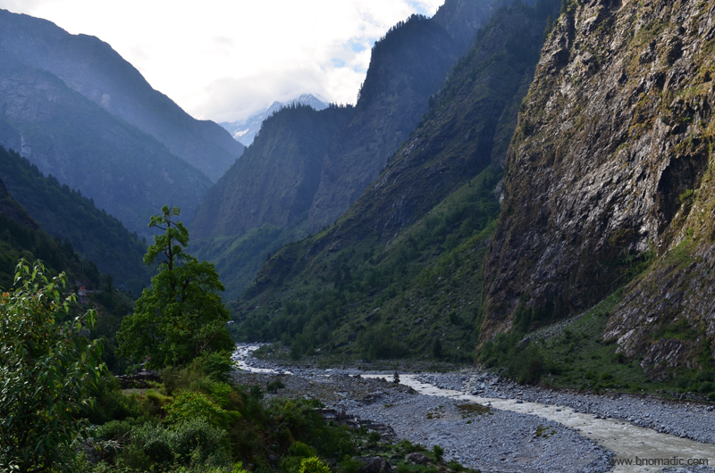
One thing you wouldn’t miss on this highway is temples and shops selling prasad and puja souvenirs. Being on a traditional pilgrim route, you’d notice a temple of repute every 20km or so with many of them destroyed and rebuilt after floods or other natural calamities. We drove along the Alaknanda under the shadow of the icy expanse of the Himalayan peaks to experience that travelling is the natural extinct of our being. Even as we were following a traditional pilgrim route, we were not pilgrims; but for us this experience meant much, much more than a pilgrimage. To travel along this route was to experience the interplay of history and geography at every turn.
The awareness of natural features is basic equipment for the traveller. One needs to know the personality of a river from its source to the estuary both as a practical aid and as an aesthetic advantage. As we left Srinagar, a large reservoir of greenish water of the dammed Alaknanda appeared like a high-Himalayan lake from a distance. A few kilometres after this dam site, we stopped for lunch by the highway. From the windows of this newly constructed restaurant, the view of the valley floor was spectacular.

The dammed Alaknanda just before Rudraprayag. Photo by Sarabjit Lehal
We were lunching only a few kilometres before Rudraprayag, the confluence town of Mandakini, that descends from the Kedarnath region, with the Alaknanda. The waiter at the restaurant, a young man who was a local recalled before us the horror of the 2013 flash floods. The settlement of Rudraprayag (720m), seventy kilometres from Devprayag, bore the brunt of the floods as being on the valley floor it received swelling waters from both the rivers. Rudra, one of the many names ascribed to Lord Shiva, gives this place its name. It is said that Shiva performed the Rudra Tandav here, which depicts him in his role as the creator as well as the destroyer. Nature will always be supreme. All of India’s rivers undergo astounding changes during their seasons; from the slack shy pools of winter to fearsomely swelled muddy torrents in monsoons.
Our next stop was the memorial built at Gulabrai to commemorate Jim Corbett’s kill of the man-eater Leopard way back in 1926. Reputed to have killed more than 125 humans, the leopard was killed by Corbett after more than ten weeks of search and hunt. Such was the terror of the leopard that the locals continue to hold an annual fest at the memorial site to this day. We bought some fruits and topped our supplies for the remainder travel of the day.

The memorial at Gulabrai, Rudraprayag. Photo by Sarabjit Lehal
The road condition had improved after Devprayag. Our next stop Karnaprayag, 31 km from Rudraprayag was reached in no time. On the way, we crossed Gauchar, a settlement that gained fame with the onset of state managed Char Dham annual yatra. Situated at the confluence of the rivers Pindar and Alaknanda, Karanprayag is surrounded by high Himalayan peaks of Nanda Devi, Trishul and Dron Giri, etc. Legend has it that the great warrior hero of the Mahabharata, Karna, prayed here for three years and was rewarded with an impregnable shield by his father, the sun God, Surya. From this town a narrow road, being widened by the BRO, by the Pindar connects Garhwal with Kumaon.

The Alaknanda Valley at Gauchar. More images from the region at Flickr

Thats the Karanprayag. Photo by Sarabjit Lehal
The marketplace of Karnaprayag is a good option to top up the supplies if you are heading towards Badrinath or the Valley of Flowers. The road ahead climbs to reach the next prayag Nandaprayag, a large village at an average altitude of 1320m. This prayag is the confluence of rivers Alaknanda and Nandakini, originating from Shivasamudra Glacier, which can be approached through the popular Kuari Pass – Tapovan Trek.

The sacred Vishnuprayag. A temple dedicated to Shiva is situated just above the sangam
Reaching the next prayag, the highest of all, takes rather slightly longish time. At an average height of 1600m, the small settlement of Vishnuprayag is spread above the holy confluence of Alaknanda and Dhauliganga. One needs to cross Joshimath to reach this prayag on way to Badrinath. One thing of note here is that all the prayags have been a popular mediation spots since time immemorial. The higher ones were preferred by Swami Vivekananda. The connotations of a prayag are appropriate to the Hindu belief where it is believed that the goal of life is an individual quest to merge one’s soul with the divine. Life itself is like a river, snaking its way past obstacles, surging back after petering out in the shallows of despair.

A group of pilgrims from Mahendragarh in Haryana singing melodious bhajans at Joshimath

Babaji smoking his chillum; he later discouraged me from travelling in the Himalayas but surprisingly offered me his chillum. Holy Smoke!


A blockade imposed by the administration at Joshimath to allow one way movement on narrow roads.

A road blockade normally lasts a couple of hours; enough for the cooks to prepare a group’s evening meal.
Further ahead, the distance between Vishnuprayag and Badrinath isn’t much (32km) but it might take more time than necessary due to road-breaks imposed by the administration to facilitate rather quick and safer flow of traffic on narrow roads. If required, prefer a night halt at Joshimath than anywhere else. Specifics of this route will be covered soon on bNomadic.
The infant Alaknanda near Ghangaria. Please visit Flickr for more images of the region
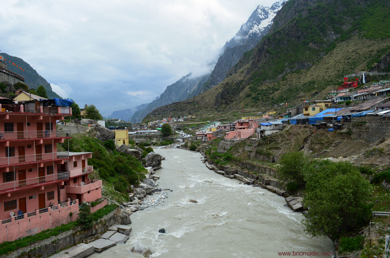
The Alaknanda at Badrinath. More images at Flickr

The Badrinath Dham by the Alaknanda. For more images, please visit Flickr
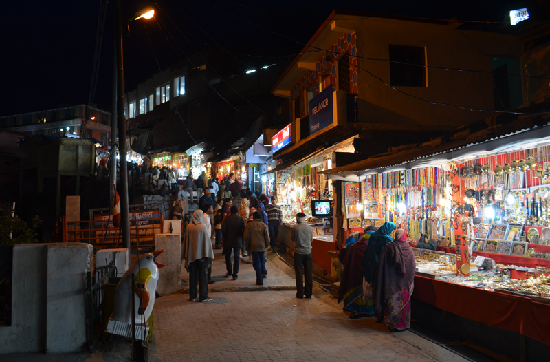
The evening bazaar at Badrinath. Please visit Flickr for more images from the region
Insofar as road safety on hills is concerned, always remember that driving on the mountains and driving on the plains are two different experiences. Not only the machinery of your vehicle, but your skillset also needs a refinement up here. Honk on curves and turns. A vehicle climbing uphill should be given a priority. Do not unnecessary get into speeding or overtaking mode. Watch out for falling rocks, normally marked by the agencies, and cross them as soon as possible once you are sure of a clear passage. Make a mental note that the hillside of Garhwal is more fragile in stability as compared to the other regions like Kumaon or Himachal.

A group of pilgrims taking the evening aarti at Badrinath. More images at Flickr
Disclaimer: This post, Road Tripping through Alaknanda Valley, my road trip adventure has been chronicled for CEAT Tyres in association with BlogAdda.


Alakhnanda is simply gorgeous. Loved this one.
Thanks 🙂 The upper valleys of Alaknanda are all very beautiful. Plus they are all accessible.