 bNomadic
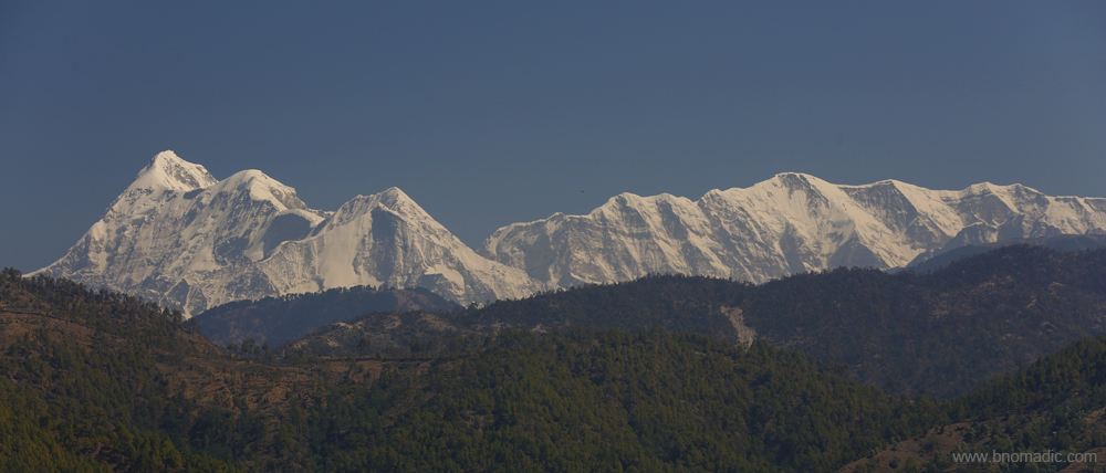
Earlier last month we were in a fertile corner of the Kumaon Himalayas. Following the Pindar River upstream from where it joins the mighty Alaknanda at Karanprayag, where forests cover the upper part of nearby ranges; we reached a much greener and salubrious part of Garhwal – “Gwaldam” – where it shares its border with Kumaon. If we leave aside the hiccups of rock cutting and road construction, our drive from the dusty Karanprayag to the hamlet of Gwaldam was a pleasant one.

Karanprayag: Confluence of Pindar and Alaknanda rivers. bNomadic photo by Sarabjit Lehal. More at Flickr
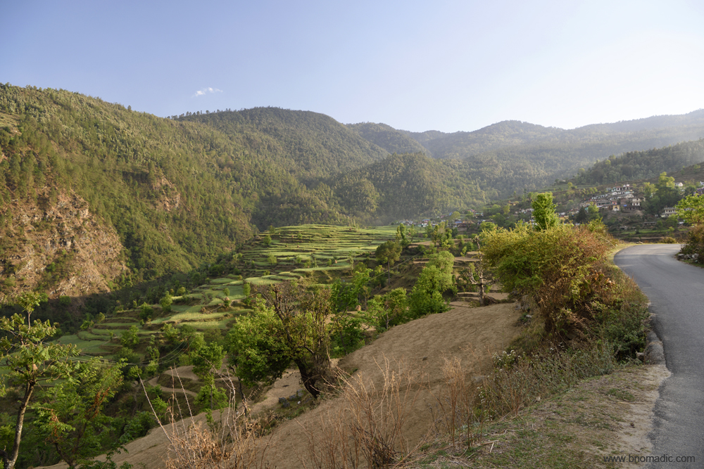
A fertile tract of land in the Pindar Valley. Photo for bNomadic by Sarabjit Lehal. More images at Flickr
As we rise higher on the road, now being widened by the BRO, a feeling of exhilaration possesses the mind. The lungs get to breathe the pure, fresh and deliciously cool air. Down below, as we ascend the narrow road, the deep Pindar gorge is filled with light shrubbery and above us are densely wooded ridges. As far as the eyes could locate, the greenery is intersected by a white line of the white Pindar. A light drizzle welcomes us to the higher reaches. As the road begins to climb after Tharali, the lush aroma of the wet woods begins to stimulate our senses.
A terraced portion of a fertile ridge. Photo for bNomadic by Sarabjit Lehal. More images at Flickr
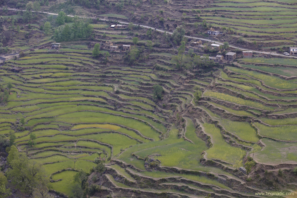
A prosperous village in Pindar Valley. Photo for bNomadic by Sarabjit Lehal. More images at Flickr

The staple crop grown here are chuwa, phaphar and mandua in Kharif season and barley in Rabi
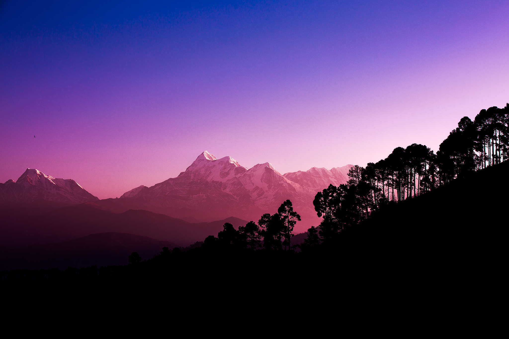
The gaze captures dense forests of rhododendrons and oaks as well as thick grey clouds blanketing the snowy Himalayan peaks towards the northern horizon. The plantation of pines on the adjoining hillsides gives the sylvan cover to the settlement of Gwaldam (1946m). The ridges and ravines all around are abounding with wild forests or patches of rock made barren by snow. The rising wood smoke from small houses in the settlement shines out in the fading evening light. In the vast landscape, the evening casts the valley with shadow as countless electric lights coming from the settlement shine out. Within the next few minutes, the busy looking small market of Gwaldam greets you. The state run GMVN TRH is sited just perfectly above the market. The caretaker at the TRH is full of information about the region. Positioned on the saddle of Gwaldam-Shisakhani ridge and Gwaldam-Badhangarhi ridge, Gwaldam enjoys the salubrious weather throughout the year. South of these ridges is Kumaon and north is Garhwal. The famous Nanda Devi Raj Jat Yatra passes through this little heaven; also a base for trek to the mysterious Roopkund Lake, Bedni Bugyal or the Lord Curzon Trail. We call it a day after a cheesy evening meal.
Next morning, I wake up to the sound of our bathroom geyser hissing with the formation of the steam. Its automatic feature to cut off the electric supply is clearly not working. Outside, the weather looks clear. The drizzle of previous evening did the wonders. Soon we are up and about to catch the first rays of the sun. The rising sun casts a magical alpenglow on the Trishul (7120m) and Nanda Ghunti (6309m) peaks. Soon the entire valley is mystified with pinks and blues. Covering every inch of landscape, the valley and ridges around have assumed the loveliest verdure; as the eyes are feasted with delicate sky and endless greenery that changes its tone with every fold and dimple of the rippling hills. The tip of the Kedar Dome glitters above an extension of the Kuari ridge. The view towards the vast bowl of Kumaon’s lush Katyuri Valley is blocked by a ridge densely carpeted with pines. Awestruck by the beautiful landscape before us, I sit deep in thought and wonder how the sentinels of Garhwal and Kumaon would force to fight to gain supremacy over each other in such a godly landscape.

The settlement of Gwaldam; morning view towards Garhwal. Photo for bNomadic by Sarabjit Lehal. More at Flickr
With the Trishul and Nanda Ghunti in the frame, an artistic capture of the morning landscape by Sarabjit Lehal for bNomadic
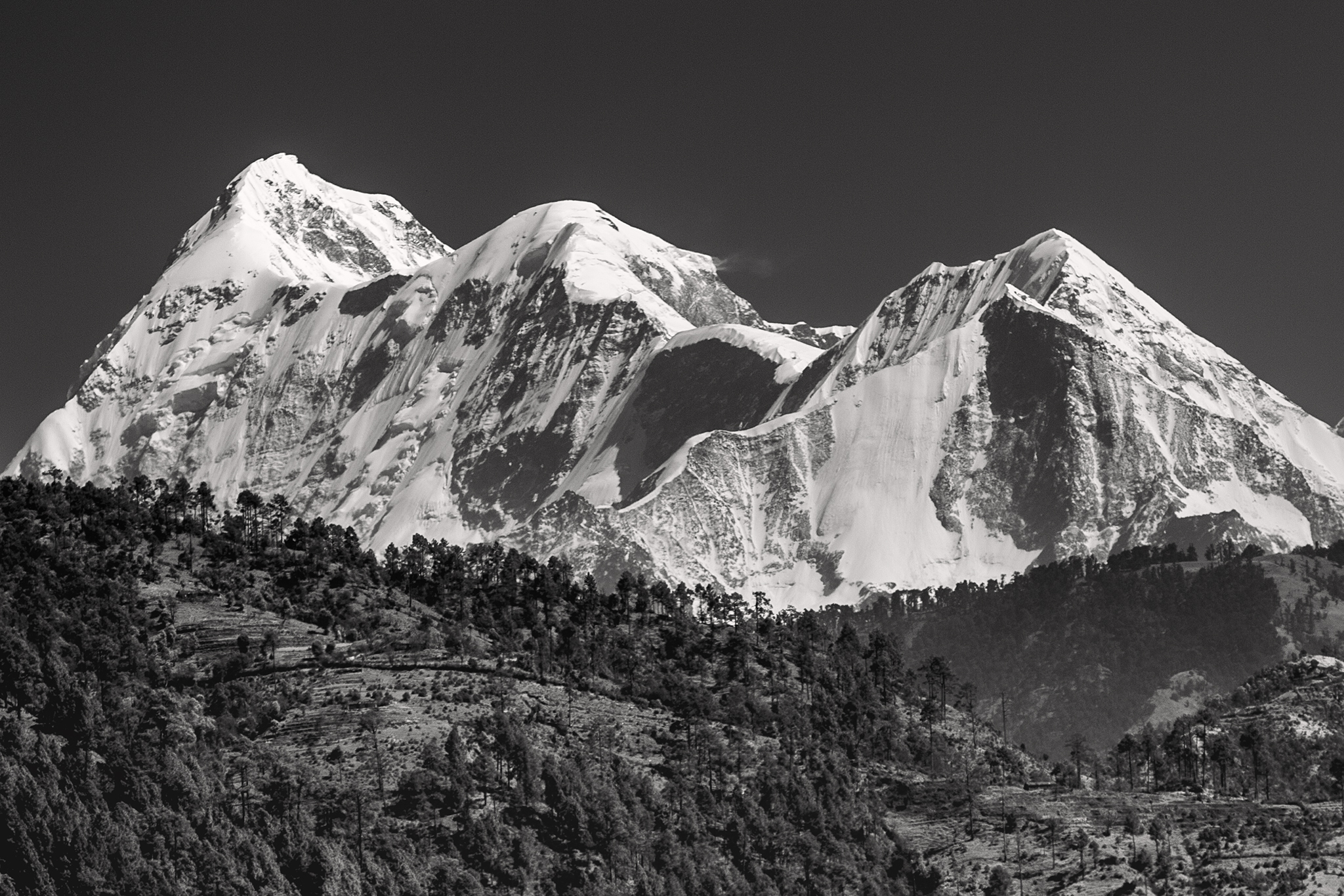
An artistic closeup of Trishul captured from a point near Gwaldam. Photo by Sarabjit Lehal. More at Flickr
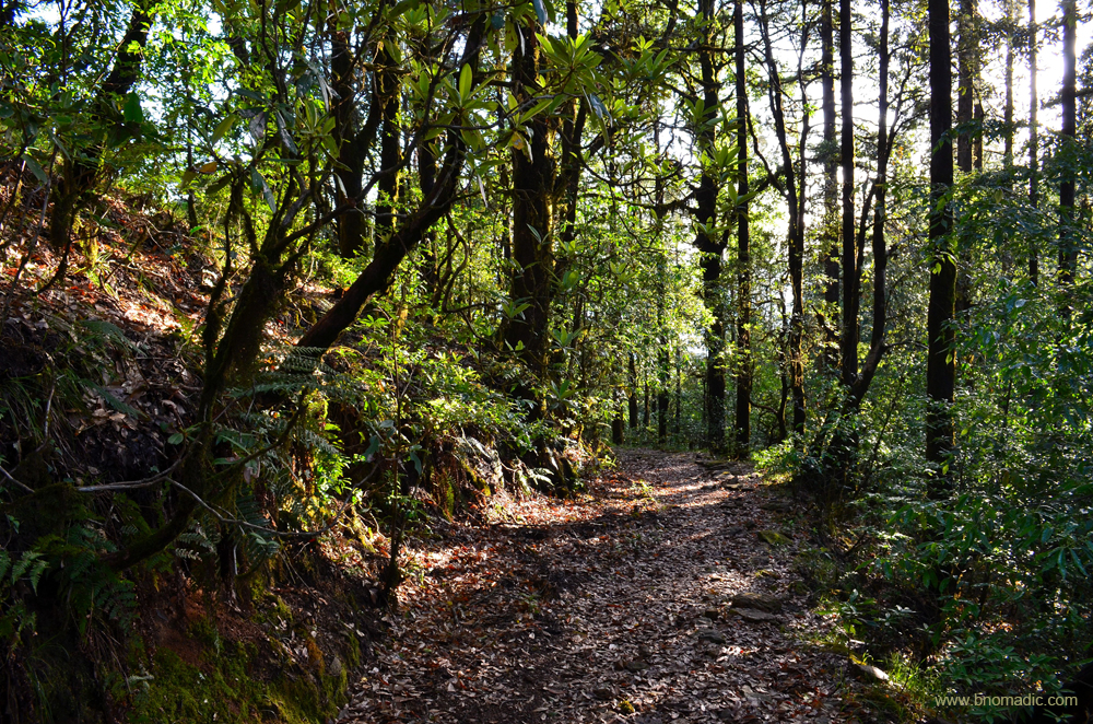
A wooded trail atop the Gwaldam ridge. Please visit Flickr for more images from the region

A closeup of Trishul as we leave Gwaldam. Photo for bNomadic by Sarabjit Lehal. More at Flickr
Gwaldam was one of the 52 garhs (forts) of ruled by chieftains in Garhwal, and being on a strategic location, it remained an apple of discord between the Garhwal and Kumaon kings. Things were calmer till the eleventh century when Katyuris, who hailed from Joshimath in Garhwal, ruled the region. The onset of chiefdoms of Chand rulers, Panwars and Gurkhas brought internal troubles to the Himalayan land. The advance of the British in the valley much later in the nineteenth century calmed down the situation. Later, the weakening of the Gurkhas watered down the dissonance and brought cordiality in relations between the two Himalayan chiefdoms. Subsequently, the British not only established an outpost here but developed it as an idyllic summer resort for their soldiers. After 1947, the relations between the two neighbours turned much friendlier than noticed earlier.
Soaking in the sylvan weather of Gwaldam, we start for Baijnath (1134m), the erstwhile activity centre of Katyuri kings. The hillsides we cross are utilised for cultivation; and converted from arid rocky declivities swept bare by rain-torrents, into fruitful fields and orchards. Varieties of wild flowers and ferns grow all over this region steeped in myths and folklore; where locals hold the Katyuri kings in the same league as their deities. For instead of any military exploits, the Katyuris are remembered more for their love of art. The erudite Katyuris invited master craftsmen from the plains to build numerous stone temples in the region and adorned them with sculptures. In their heyday, the Katyuris ruled the entire territory from eastern Himachal Pradesh to western Nepal including the Terai-Bhabar region. From Joshimath, the Katyuris later shifted their capital to Katyur near Baijnath.

The valley of Gomti, also known as Katyur Valley. Please visit Flickr for more images of the region.

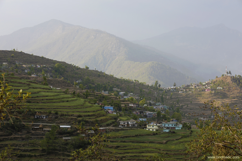
A fertile patch in the Katyur Valley; in addition to the usual crops, turmeric, ginger and chilli are also produced here
From the car parking site adjacent to the bridge on Gomti River, a small causeway takes you to the temple site Baijnath. Comprising a total of 18 shrines on the left bank of the Gomti, the temple complex of Baijnath is said to have been built between the ninth and twelfth centuries by the Katyuri kings. Most of the shrines save for the main one which houses a magnificently carved statue of goddess Parvati, have been locked away. The entrance gateway to the main temple has innumerable brass bells hung by devotees. The intricate Hanuman and Ganesha carvings are also noticeable around this shrine. A major part of the complex was rebuilt using the original stone in the nineteenth century; nearly hundred years after it was destroyed by the Mughal emperor Aurangzeb.
The gazetteer records a population of mere 117 souls in 1881 in Baijnath, the centre of the Katyur Valley. During those times, the valley was studded with tea-plantations which were the preferred haunts of tigers and bears. The ancient temples were used as corn lofts and storerooms. Gosains from the region observed the custom of burying their dead in small temple like tombs around the building in which they worshipped. Several olden sculptures were studied along the walls, most of which were of modern Hindu origin but one was found to be a representation of Buddha. This is in accordance to the travel notes of the Chinese traveller Hiuen Tsang who mentions that followers of Buddhism also lived in the area.

The Baijnath temple complex by the barraged waters of Gomti. Photo for bNomadic by Sarabjit Lehal.
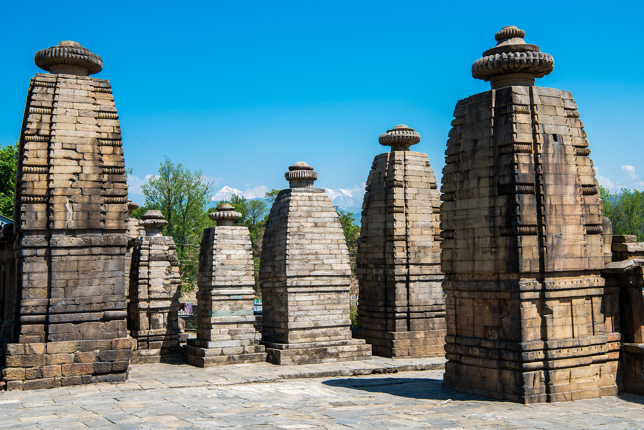
The Baijnath temple complex assumes significance because as per the folklore, Shiva and Parvati were married at the confluence of River Gomati and Garur Ganga. Photo by Sarabjit Lehal
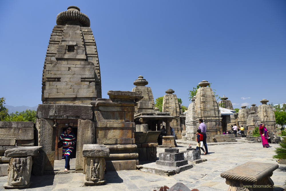
It is claimed that the main shrine was built in one night by the Katyuri kings. More images at Flickr

Dedicated to Shiva Vaidyanatha, the God of Physicians, the Baijnath temple complex has idols of Shiva, Ganesh, Parvati, Chandika, Kuber, Surya and Brahma. Photo for bNomadic by Sarabjit Lehal. More at Flickr

The temple pujari guarding the main shrine. Photo for bNomadic by Sarabjit Lehal. More images at Flickr

The statue of goddess Parvati inside the main shrine.
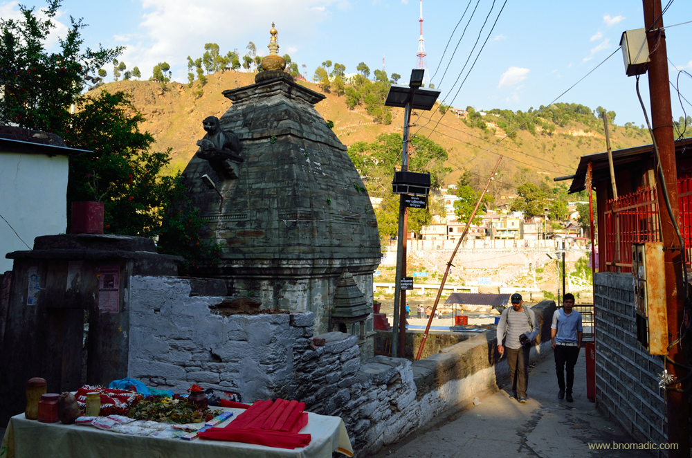
Next, we head towards the district headquarters of Bageshwar (904m), flocked by both pilgrims and traders since time immemorial. The road from Baijnath to Bageshwar follows the left bank of the Gomti. The river Gomti originates from the Birchuwa peaks and Gadwalbunga and flowing through the Katyur valley join the Saryu on its right bank at Bageshwar. The river support many villages and tea factories. The settlement, situated by the luxurious confluence of Gomti and Saryu rivers (not to be confused with Gomti of Lucknow and Saryu of Ayodhya) is dotted with numerous ancient temples. The temple complex of Bagnath is the main draw. Built in fifteenth century by Lakshmi Chand, the temple has idols many of which date back to seventh to sixteenth century. On the opposite bank, atop a small hillock Neeleshwar Parvat, is another ancient Shiva temple. A 20 min hike takes you to the top. In January every year, the temples come alive during the Uttarayani Mela around Makar Sankranti.
Not only a centre of attraction for pilgrims, Bageshwar used to be a great mart for exchange of Tibetan produce between the Bhotiyas from Tibet and the Almora merchants. Atkinson writes that during winters the roads leading to Thal (towards Munsyari) were crowded with “flocks of goats and sheep conveying borax and salt from Bhot and grain and rice in return, while numerous parties of lowlanders are seen carrying kiltas of oil which they exchange in Bhot for wool”. The religious fairs of January were also frequented by Kumaon traders and the Bhotiyas from Tibet.

The fertile valley of Bageshwar. Photo for bNomadic by Sarabjit Lehal. More images at Flickr

Matchbox type houses in the valley. Photo for bNomadic by Sarabjit Lehal. More images at Flickr
The Bagnath temple is a protected monument and looked after by the ASI. Photo for bNomadic by Sarabjit Lehal.
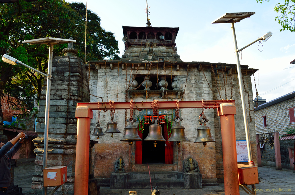
The architecture marvel of Bagnath Temple is festooned with bells of all sizes. Photo for bNomadic by Sarabjit Lehal. For more images, please visit Flickr

As per Hindu mythology, Sage Markandeya worshipped Shiva here. God Shiva blessed the sage by visiting here in the form of a Tiger; and hence the name. More at Flickr

The upper reaches of Bageshwar; captured near Kanda. More images from the region at Flickr
Teeming with fishes, the river basin is surrounded by high wooded ridges. The settlement is spread on both sides of the Saryu. Observed from top of the surrounding ridges, the houses in the valley give the impression of matchboxes. Historians found evidence of a non-Hindu settlement in Baijnath of the Katyuri valley. Likewise, inscriptions found in this valley also depict a far earlier foundation than the fifteenth century ruled by Chand dynasty. Certain structures discovered in the Katyuri valley have been assigned to Mughal colonies.
Getting There
The valley of Bageshwar is 21 km from Baijnath which is 23 km from Gwaldam. Almora is 92 km from Gwaldam and Bageshwar is 73 km. Karanprayag to Gwaldam is 68 km.
Average Altitude: 1200m
Best time to visit: Winters; avoid monsoons
Travel Lure: Himalayan views and natural heritage
Accommodation: Available


Love how you bring up such less known yet beautiful places. Very well written post, looking for more! 🙂
Thanks Enakshi! Glad you liked the post. Keep showering your love and support 🙂
Absolutely loved this. Sorry for not visiting earlier. Will be stalking your blog for a few days now. 🙂
Thanks Tikuli! I’m glad to see you back here. Keeping my fingers crossed now.
😀 I am always luring around somewhere.
Great post.
Thanks Mick! Keep visiting bNomadic 🙂
Everytime i see a travel blog with such awesome pictures…gives me an urge to wander, visit all these awesome places myself!!! 🙂
Glad you liked the post Deepa! Happy to know that it is motivating you to travel. In fact that is the purpose behind this blog. Keep visiting bNomadic for more such travel stories 🙂
Lovely photo of Trishul in the morning. Brought back great memories.
I can relate to that Sir. Such heavenly mountain scapes get forever etched in the mind. Keep visiting bNomadic for more such travel stories 🙂
Am awestruck with the beauty of our hills and valleys and you have captured them so well! The Gomti or Katyur valley looks splendid. ….. and how can we forget the temples. Wonderful comprehensive post. Thanks for penning your experience & sharing. Fantastic pictures of the Trishul and the Katyur valley!
Thanks for dropping by the blog admin! And for your feedback. Katyur region is among the most culturally rich pockets of Kumaon. There is so much more to explore. Hopefully in near future. Keep visiting bNomadic for more such travel stories.
Such a nice post!
Thanks Syam! Glad you liked the post. Keep visiting bNomadic for more such travel stories