 bNomadic
Next morning, I take it rather easy initially but as I leave the Rest House, I gingerly manoeuvre my vehicle to climb the narrow dusty bumpy motorway to Chanshal (3784m). The air outside is fresh but every descending vehicle, load carriers mostly, whips a cloud of dust along. It is already nine. The sun beams are streaming onto the Pabbar valley which is now enclosed by high hills. The road changes bank at village Tikri. After the Tikri bridge, the narrow paved but potholed road steadily climbs for the next 10 km to reach Shiladesh, where multiple marketing agencies are working day and night to make the best out of the remaining few days of the apple harvesting season. Until few years ago, the tarred road existed up to Tikri but now Shiladesh is the point after which it’s all stony but slight wider. The settlement of Larot is still couple of kilometres away. I take nearly two hours in reaching Larot (2620m) from Sandasu. But that’s okay, taking notes and making photo-records does take time. Being a travel writer is totally different than being on a holiday.

The road to Tikri by the Pabbar River. Please visit Flickr for more images of the region

The Pabbar cascading down the valley at Tikri. Please visit Flickr for more images of the region

The settlement of Tikri perched high above the Pabbar. Please visit Flickr for more images of the region
By writing about the rarer corners of the Himalayas, travel writers are somewhat responsible for taking the veil off a secluded land. More writing means more advertisement. The Himalayas offer thousands of kilometres of rugged kutcha tracks for rallying through its valleys, forests, along its mighty rivers and over its famous passes. The concern of vehicular exhausts polluting the virginal peace of the mountains is a sour matter. But then there is a lot to be said regarding the use of a vehicle to reach the lesser visited portions of the Himalayas and get an access into the hidden cultures and geographies. Responsible travelling requires us to have a heart with respect to every aspect of environmental health. This calls for a special empathy for the ecosystem as well as the cultural traditions that have grown out of it. Visitors and locals grow together and a sense of this living relationship is what Himalayan travel ideally ought to inspire. This thought makes me even more responsible as I negotiate the slopes ahead.

The agriculture fields of village Tikri by the Pabbar. More images from the region at Flickr

The scenic village of Larot perched high above the valley. Please visit Flickr for more images of the region
Just a kilometre ahead of Larot is the teashop at Shagulta. The wanton destruction of hills is yet to reach in this area. The pit stop marks the end of habitation as the road enters a dense forest belt. Hereafter, the road length to Chanshal is spanned over 15km of forest and meadow drive comprising 13 hairpin bends. My vehicle is in first gear ever since I crossed the bridge at Tikri. With not a single trace of civilisation around, I am elated to feel the old world charm of a Himalayan drive as I enter the magnificent forests of Chanshal. The climb is steep. A Tata Nano (sounding like a tractor) is struggling hard to climb. The driver stops to let its engine cool after every bend. I am a trifle surprised to notice logging and cutting of trees in this notified dense forest cover. A worker informs me that the cutting and felling of trees is very selective and is being observed by the concerned departments of the state government.

Scheme of things at an apple marketing agency; Its the end of harvesting season and apple packing is in full swing. The apples from all over the state are mostly procured on long term contract by Adani Group. The highest price the Group offers to the contractors is Rs 24 per kg. The same apples are then supplied and sold all over India on much inflated rates.

The main square of Larot that doubles up as a parking site. It has a couple of tea shops, medicine shop, a dhaba and a grocery store. Please visit Flickr for more images of the region
I stop to savour the view of the valley I have just crossed. Water is oozing out of the mountain face and cascading down in the form of small streams. Topped with some icy peaks, the Sangthar Ghati and Durgi Ghati Range is in full view. The mountains and sky are playing out the overtures of a perfect landscape. The stunning panorama of the glorious array of snowy and rocky peaks surrounding the Sangthar and Durgi Ghatis with dense green valleys below under a deep blue sky is heavenly to say the least. The overpowering scent of dense forest is the heady factor that gives me pure and instant untrammelled joy. In addition to the peaks, the pulsating blueness of sky and the wildly intoxicating tang of fresh grass is the benison of hillsides of energetic alpine foliage shining bright under the sun. Rarely has my soul experienced such a sensually unrestrained pleasure. Six kilometres before the pass, I leave the treeline to enter a vast grassy wind-swept face of the Chanshal Range.
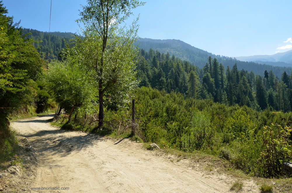
Motorway right after Larot as it prepares to enter the forest cover. Initially, it was proposed that the road to Dodra Kwar should be built from Netwar given the ease of its construction. The initial negotiations with various departments and governments started in 1976. The proposed route got negated as it passed through Govind Pashu Vihar National Park. Later in 1980s, it was decided to construct a road in Himachal itself via the Chanshal Pass. Before this the road existed up till Tikri.

Timber cutting and logging in progress. It was because of this forest and a similar stretch on the other side of the pass after Gajyani Thatch, the road construction to Dodra Kwar kept getting delayed. Obtaining permissions from the then disinterested central government was not an easy task

Must be among the largest flocks of sheep on a road (more than 3,000). I take more than 30 min to cross the flock looked after by just three men and four gaddhi dogs. More images at Flickr

Lifeline of Dodra Kwar, the state owned transport bus that makes one trip a day. As of now, only two buses ply between Rohru and Dodra Kwar. More images from the region at Flickr

A photo break just after exiting the forest cover. Please visit Flickr for more images of the region

Topped with some icy peaks, the Sangthar Ghati and Durgi Ghati Range is in full view. More at Flickr

A panoramic view of the Pabbar Valley from the slopes of the Chanshal. More images at Flickr

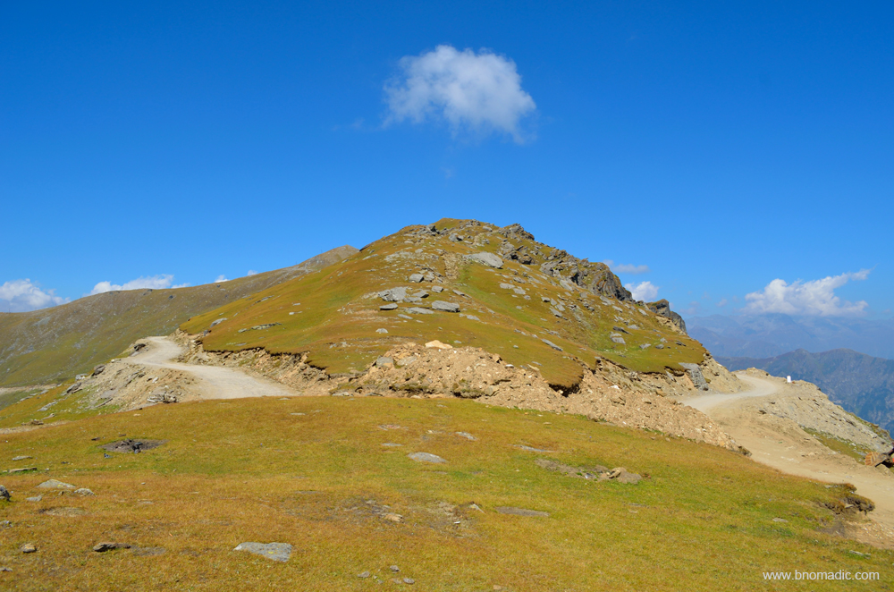
Four more kilometers to the crest of the pass, marked by a small mound. More images at Flickr

The final line of ascent. Before the advent of this road, the track was merely a rough footpath and mostly unfit for mules. Please visit Flickr for more images of the region

The mountains and sky are playing out the overtures of a perfect landscape. More at Flickr
With a few more photo-halts, I am atop the pass after driving for about five hours from Sandasu. Once again, I get down from the vehicle. The panoramic display of the icy Himalayas is truly captivating. The sweeping mountainscape encompasses magnificence as well as beauty. Here everything is on the grandest scale, fragments of fallen rocks of immense bulk, hurried from the peaks above, and vast impending cliffs fringed with dark forests, and topped with mountains of indestructible snow, appear on two sides; vast meadows spread on rounded ridges encircled by verdure, and marginally populous villages encircled by fields and orchards towards the valley floor that hardly attracts my keenness which, at the moment, is devoted to minutely observing the Great Himalayan Show.
Some emergency equipment of road workers is parked near the crest of the Chanshal Pass (3784m). Despite the fact that I am venturing into a relatively unknown territory, I am in no hurry to descend the pass which has been infamous for landslides. With every passing hour, the intensity of sunlight changes enabling me to capture different perspectives of the same landscape. Later in the day, I begin my descent towards the Rupin Valley. The motorway becomes slightly narrow. The shaded patches on the road are still slushy. A teashop welcomes me to the treeline. Ahead, the road passes through a dense forest before reaching village Dodra. It is getting dark but I still opt to continue with the same pace. As I exit the forest belt, I wonder over the amount of Himalayas, the pass has induced in my senses a while back. The green valleys full of floating mist, white clouds against a crisp blue sky, the eternal snow of the Himalayas, smoke drifting up from the valley floor, the smell of logs and fresh-cut wood, the resinous smell of the conifers, the damp smells of foliage in the forest of Gods; everything is going to be forever etched in my mind.

Probably realising the end of season, the makeshift dhabas atop the pass are no more. More at Flickr
Atop the Chanshal Pass; the left road (in the frame) comes from Rohru and the right one leaves for Kwar

Preparing to leave for Dodra Kwar. Please visit Flickr for more images of the region

The sweeping mountainscape from the Chanshal encompasses magnificence as well as beauty. Most peaks of South Kinnaur and West Gangotri region are visible. More images from the region at Flickr

Ready to descend the Chanshal. Please visit Flickr for more images of the region

A panoramic view of the Rupin Valley from the slopes of the Chanshal. More images at Flickr

The forest cover of Dodra is clearly visible below the Pass. Please visit Flickr for more images of the region.

The road to Dodra on the other side of the pass as I begin to descend. More images at Flickr

The road to Dodra Kwar descending in loops from Chanshal. Please visit Flickr for more images

A tea shop (to the right of the frame) marks the beginning of the forest cover. More images at Flickr

The village of Kwar across the valley is also visible from the slopes of the pass. More images at Flickr

The narrow motorway as it prepares to enter Dodra. Please visit Flickr for more images of the region
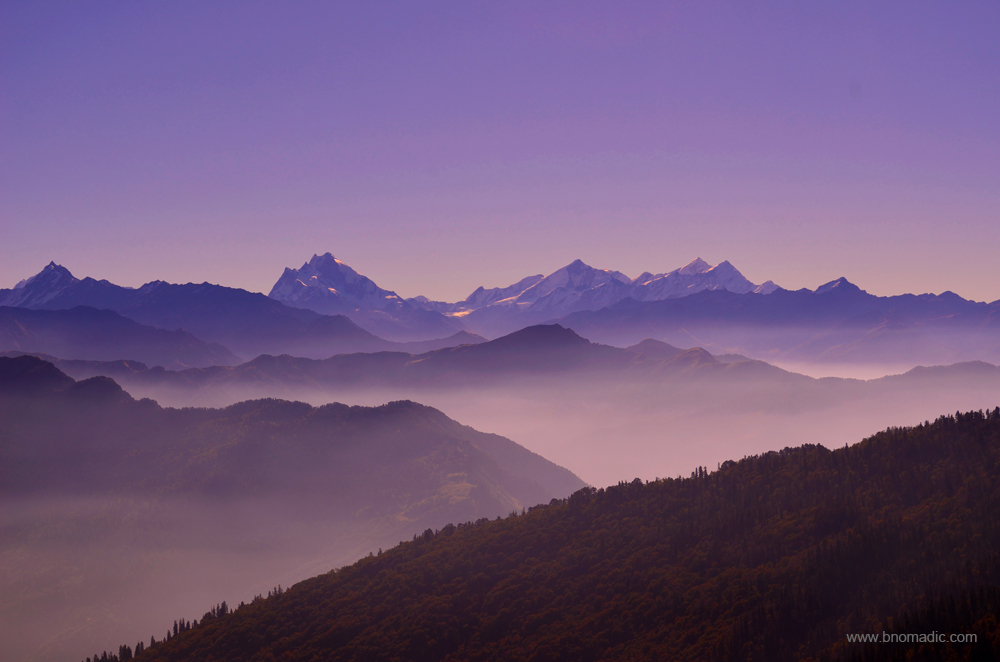
The mystic Himalayas! View towards the West Gangotri region. More images at Flickr

The magical Himalayas! View towards Western Garhwal, Uttarakhand. More images at Flickr
Getting There
The Chanshal Pass is nearly 50 km from Rohru in district Shimla. The distance between Chanshal and Kwar is 42 km. Separated by the Rupin, Dodra and Kwar are 22km from each other.
Altitude: 3784m
Best time to visit: Autumn
Travel Lure: Panoramic views and sylvan charm
Accommodation: Very limited at Kwar, Dodra, Larot and Chirgaon


Pingback: The mysterious Dodra Kwar | bNomadic
beautiful place amazing clickings
Thanks Pushpendra! Keep visiting bNomadic for more such travel stories 🙂
Beautifully written. It is indeed true that a conservationist like yourself are often faced with the predicament of revealing lesser known places at the cost of a looming fear that over exposure of the same will attract mass tourism and perhaps spoil the fragile ecosystem
Thanks Lalitha for stopping by the blog! Glad you appreciate the view. Hopeful that the coming breed of travel enthusiasts will be more careful. This also brings to differentiate between a traveler and a tourist. Keep visiting bNomadic for more such stories :-)😊
Finally a current post comprising of detailed information regarding Chanshal Pass. Beautifully written and great pictures. Looking forward to the next one!
Thanks Enakshi! Keep visiting bNomadic 😊 Next post of the series soon
Looks like a lovely place from your photos. You mentioned ” the ecosystem as well as the cultural traditions that have grown out of it”. Are you writing about it elsewhere?
Thanks Sir! Thanks for stopping by the blog. It is a general thought that I am sure every travel writer or reader would share. What are your thoughts?
I was hoping that you would be able to report particulars, since you traveled in those parts.
Of course Sir! I’d love to point that out but then nobody would want to read. It is a general thought I always feel while typing a post.
Very good writing and excellent photos. You are surely a more serious travel writer than I. Thanks for stopping by my blog. Safe journeys.
Thanks Gary! Glad you liked my blog and the photos. Keep visiting bNomadic for more such travel stories 🙂