 bNomadic
Known for the mellow splendour of its landscape, the Kangra Valley is located south of the imposing snowy Dhauladhars in the Himalayan state of Himachal Pradesh. Contrasting with the wooded beauty of the low ridges and valleys studded with charming hamlets, the mighty Dhauladhars never fails to cast a spell over a traveller. Not only for its attractive landscape, the Valley assumes a special place in a travel calendar because of its people, culture and heritage.
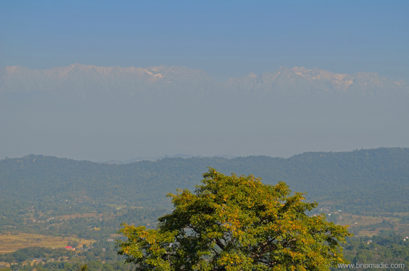
The Dhauladhars; captured near Dehra Gopipur. Please visit Flickr for more images of the region
Every winter, the mysterious forests of the Valley are thronged by Gaddis who descend from the Dhauladhars in search of greener pastures for their herd. The numerous hamlets and villages of the valley are dotted with hardworking but shy Rajputs and Brahmins. A symbol of its rich cultural heritage, the famous Kangra paintings – known for their ageless beauty – also prospered in this Valley. The ancient temples and fortifications at several spots are but a sign of prosperity and rich history. The River Beas along with its network of numerous tributaries waters the terraced fields forming a closely knitted network of wavelike embankments throughout the valley. Plenty of Palaeolithic hand tools have been reportedly discovered from these river terraces.
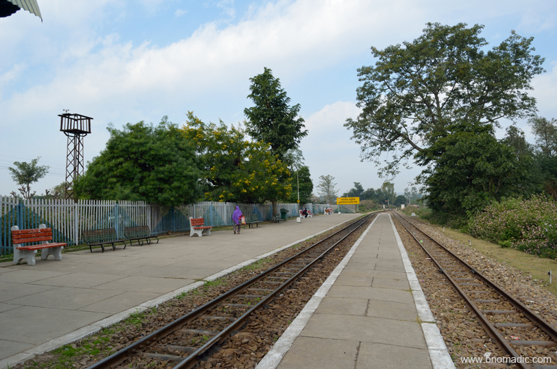
Nagrota Surian; Much of the railway line is laid along the old trade route. More images at Flickr
It was late afternoon when we reached Guler, a nondescript town on the narrow road connecting the town of Dehra Gopipur with Nagrota Surian on northern shore of the Pong Dam Lake. The wooded greens, grazing cattle herd and the tolling of temple bells assured us that we were in a culturally-rich part of the valley. I could easily relate to the Himalayan peace and harmony in the village-sound of the foothills. Close by, a railway track runs parallel to the road. Much of the railway line is laid along the old trade route which was also used by the Mughal and Sikh armies to march into the interiors of the Valley from the seventeenth to early nineteenth centuries. Around here are the terraced fields or orchards flanked by low ridges that were once the abode of the Ice-Age men.

The Banganga, a monsoon torrent with hardly a trickle of water in its bed that was strewn with rounded pebbles.
Passing the unpretentious town of Guler through its wooded groves, we reached the Banganga, a monsoon torrent with hardly a trickle of water in its bed that was strewn with rounded pebbles. Built on a precipitous ridge, across the torrent, a fort-like structure of Haripur comes into view. Although dilapidated, the fort still dominates the landscape and testifies its hold as an impression of power in its heydays. The road briefly ascends to reach the marketplace of Haripur, an olden settlement built on giant boulders flanked by an arc-like ridge capped by the fort in the north and a temple of Durga in the south. All through the road one would notice expansive spread of ficuses; at the base of which are platforms on which wayfarers could rest. Painted white, the houses and temples nestle in the shade of such giant banyan and pipal trees. We drove through the narrow lanes of the bazaar; arousing some basic curiosity among the residents and shopkeepers of Haripur. On the way, we came across several ruined structures, temples and neglected tanks.
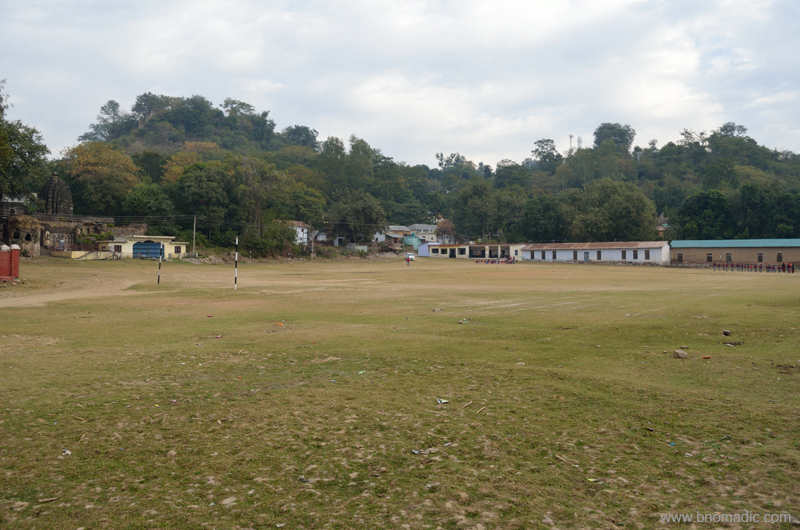
The chaura maidan where the royal families used to play polo. More images from the region at Flickr
BC Hugel, who saw Haripur Guler in 1835, was impressed by the culture and lifestyle of locals. He writes that the houses were clean and in front of them was usually a small garden stocked with lilies, balsam, rose and jasmine. Men wore trousers and black turbans and invariably had dark, long beards. Women wore blue petticoats with deep red borders and pink veils on their heads. The typical beards and black turbans, in general, are no longer popular with men. Even the colour schemes popular with women has changed and so is the costume. The houses are still clean but with no specifically maintained plantains.
Passing through the main bazaar we reached a chaura maidan. It was here, where the royal families used to play polo, a game of Persian origin that was introduced into India by Akbar. Marking the boundaries of the polo ground are several ruined temples and similar structures. We could still not have a close-view of the fort from the ground.

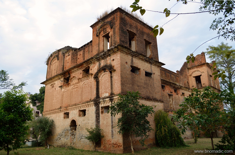
The Haripur Guler Fort; Much damaged by the earthquake of 1905, and shattered by the tentacle-like roots of the pipal trees which had grown in the cracks in the walls, the fort is still impressive.

One of the olden temples adjacent to the Royal Polo Ground. More images from the region at Flickr
We decided to spend the night in the PWD bungalow just adjacent to the polo ground. Next morning, we roamed around and gathered some more dope and lore from the locals. The princely state of Guler is a pretty old one and has an interesting story behind its formation. It was founded in 1405 by the then ruler of Kangra Raja Hari Chand after he was rescued from a forest in which he got lost while on a hunting expedition. Guler was later annexed by Ranjit Singh in 1813. The state of undivided Punjab made an exceptional contribution to the art of India by producing marvellous art pieces popularly known as Kangra paintings. And it was this very place – Haripur Guler – from where this new art cult originated in the eighteenth century.

Morning at Pong Dam Lake. Please visit Flickr Photoset for more images of the region
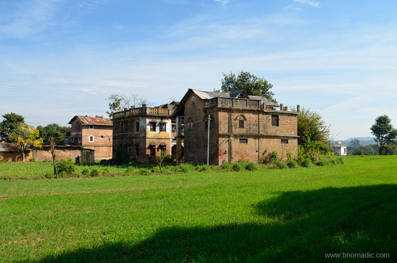
Ensuing day, in search of some permanence by the Pong, we stumbled upon the royal castle of Nandpur – part of the Guler state – and located at just a 30 mins of driving time from Haripur. Even though, the castle is within a walker’s distance from the village railway station, reaching it is a task nevertheless. A descendant of the royal family of Guler, Raja Shamsher Singh got the Nandpur hillock as a jagir from the Sikh rulers in 1826. Claimed to be built in 1870s, the red-brick castle must have witnessed many a royal functions or events. The overall structure still appears to be the same but the building is in serious need of renovation.
The Castle of Nandpur Guler (now in ruins). Please visit Flickr for more images of the region
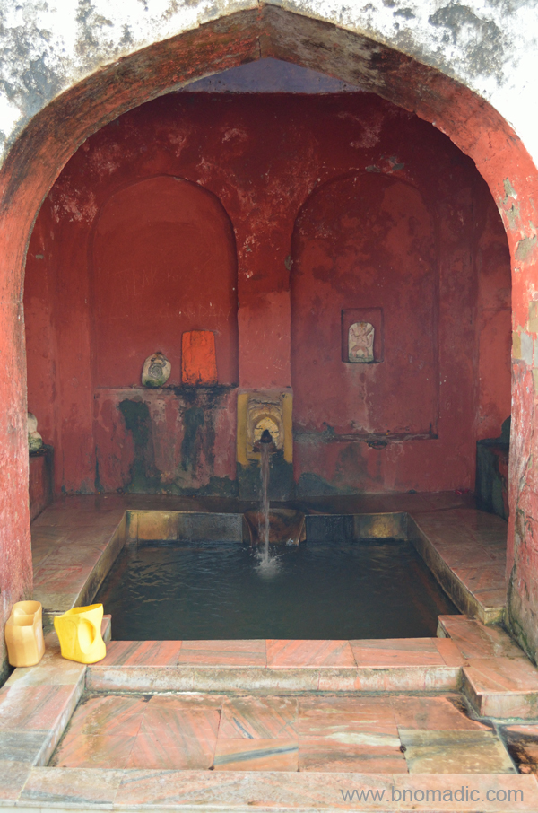
Next day we decided to go to the Tatwani hot sulphur springs located not very far from Nagrota Surian. Admiring the snowy wall of Dhauladhars we crossed the Gaj Khad and found ourselves in the village of Tatwani flanked by orchards and fields. The village is approachable through a tarred motor-road as well. Inside the simple compound of the temple, we came across the deep stone bath of Tatwani in which the warm outpouring of sulphur water trickles down from an ornately sculpted faucet. Just around the site, I spotted numerous smaller shrines dedicated to Shiva.

The Gaj Khad and the snowy wall of the Dhauladhars. More imagery from the region at Flickr
Legend has it that the hot sulphur springs were discovered by the King of Chamba who later got a temple constructed here. More at Flickr

Tatwani; Everything else including the boundary wall is a recent addition. More images at Flickr
Our curiosity next led us to the heritage villages of Paragpur and Garli near Dehra Gopipur. The villages came into touristy limelight after being declared as a “heritage zone” by the state government in 1997. The region was once under the chiefdom of Jaswan. Legend has it that the Chief appointed Kuthiala Soods to find an appropriate place in his territory using ancient Indian texts where he could commemorate Princess Prag Devi’s victory against certain marauding bands in the area. The village of Pragpur is in the reflective shadow of the Dhauladhars and is said to receive the primordial astral energies of prayers being offered at the temples of Bajreswari, Jwalamukhi and Chintpurni.
The heritage village of Pragpur. Please visit Flickr for more images of the region
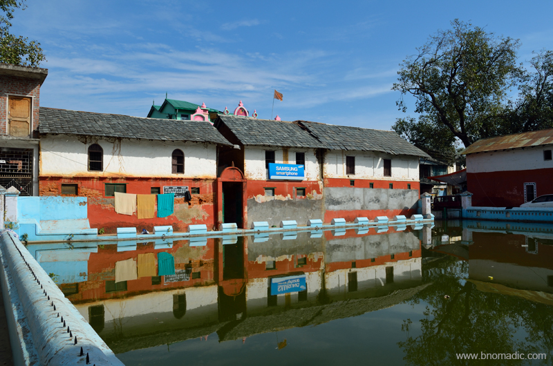
Built before 1868, the Taal is said to form the core of Pragpur village. It was constructed by the village Nehar Committee that still continues to be responsible for its upkeep. The pond is surrounded by several olden structures like the Nehar Bhawan, Naun, Dhunichand Bhardial Serai and Radha Krishna Temple.
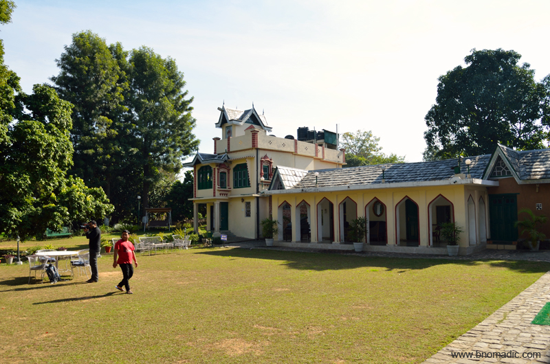
The compound of The Judge’s Court at Pragpur. More images from the region at Flickr
We took a stroll in the cobbled lanes connecting the architecturally fascinating buildings of the charming hamlet of Pragpur. It was intriguing to notice the houses built in varied architectural styles ranging from local to colonial and even Portuguese. Locals say that after the prosperous Kuthiala Soods arrived in the early nineteenth century, they brought in these typical architectural styles from abroad. Subsequently, some of these fascinating structures were abandoned as their owners shifted elsewhere. The grandest and most famous of such structures is The Judge’s Court, a three century old residential complex that has now been converted into a resort.

The rock-cut Masroor temples and lake. Please visit Flickr Photoset for more images of the region
Another architectural marvel from the medieval era– the rock cut temples of Masroor is located at an hour’s drive from Nagrota Surian. The following morning, we reached the sandstone ridge, above the village Masroor, where the set of fifteen monolithic temples are hewed out of rock in the Indo-Aryan style. With the absence of any epigraphic or literary record that might throw some historical light on the temple of Masroor, only an approximation has been made to say that it might have originated in somewhere around eighth century. However, the existence of this temple was noticed as early as 1875 but its rock-cut character was not appreciated until ASI visited it in the year 1913.

The original image of the sanctum went missing; currently the main shrine has stone images of Ram, Lakshman and Sita. Please visit Flickr Photoset for more images of the region

A substantial part of the temple was damaged in the earthquake of 1905. More at Flickr Photoset
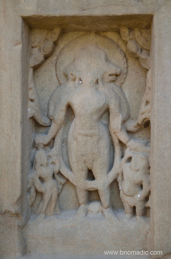
Vaikuntha; More images at Flickr
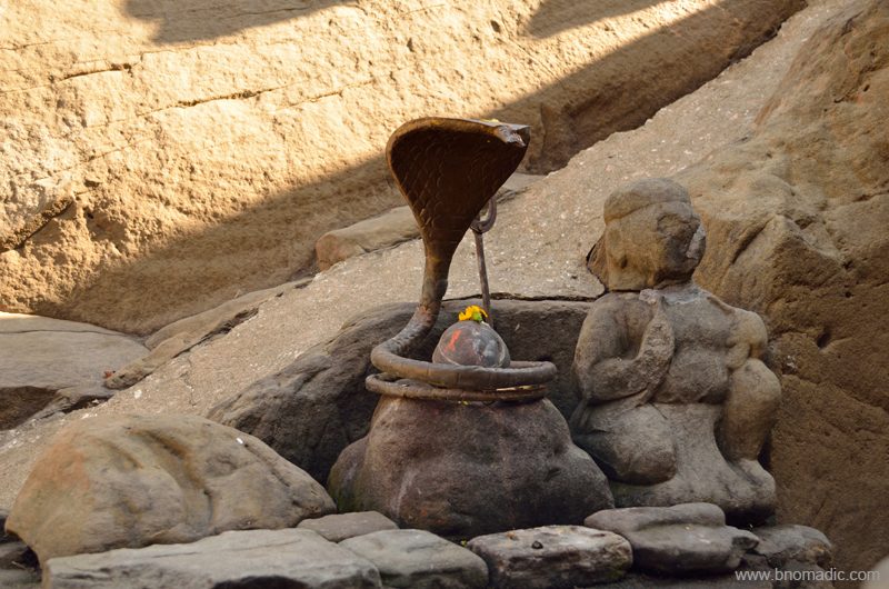
Obviously a later addition; जय भोले नाथ! ॐ नमः शिवाय!. More images from the region at Flickr Photoset
Notwithstanding the deadly earthquake of 1905 that nearly ruined the complex, the exquisite rock carving of the temples portrays a rich past. The original image of the sanctum went missing and currently the main shrine has stone images of Ram, Lakshman and Sita. The presence of the figures of Shiva in the centre of the lintel of the main shrine is a strong presumption for historians that the temple was originally dedicated to Mahadeva, the presiding deity of the Himalayas. From the top of the sandstone ridge that has many caves and dwellings; one can look down into the valley on either side. Towards the front of the complex there is a tank that has also been hewn out of the sandstone. Locals relate this small pond that is supposed to retain water throughout the year, with Pandvas and Draupadi.
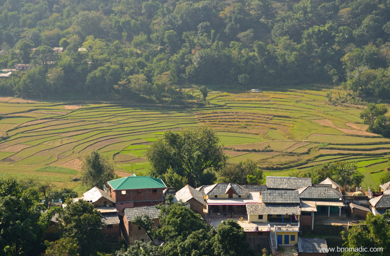
Terraced fields and the village from the Masroor ridge. More images from the region at Flickr Photoset


Lovely post. I have been to Kangra but never knew of these castles and temples. Time to revisit perhaps.
Thanks. 😊 You could club these castles with Pong whenever you plan to visit the region. More gems from the region soon on the blog. Keep visiting ☺
Loved reading your post. Kangra valley is a fascinating place . Its mystique is only increased by Dhauladhars that stand guard at one end of it,
Thanks xplorazzi for stopping by the blog. Truly a mystic place as you venture deeper into the valley. The shadow of Dhauladars is magical. Keep visiting bNomadic for more travel stories 🙂
Excellent post. I have never been to Kangra, but after reading i love to visit there.. Nice work bNomadic…
Thanks. You must visit the Kangra Valley someday soon. In the meantime, keep visiting bNomadic for more such travel stories 🙂