 bNomadic
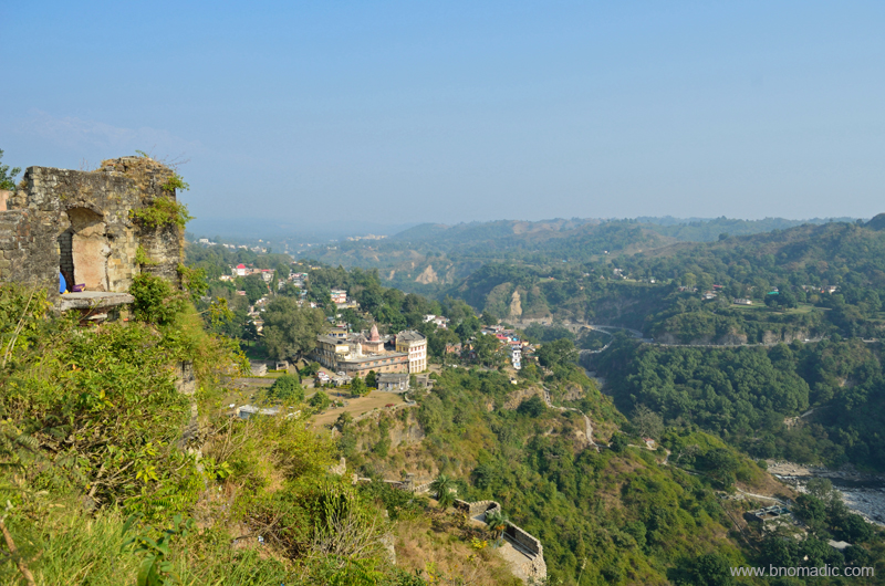
With a week-full of activities in the lower foothills of Kangra region behind us, we decided to explore the Fort of Kangra, which was the seat of power of the rulers of Kangra during ancient times. Standing on the Kangra – Hoshiarpur highway, as one looks up the towering mass of the fort spread on a precipitous cliff and listens to the gurgling of water and the whistling of wind in the Banganga gorge 300ft below, one cannot help but be wonderstruck admiring one of the most impressive fort ruins in the country.

The Fort of Kangra above Banganga and the Jayanti Devi temple in the backdrop. More images at Flickr
The locals take great pride in the historical importance of their fort, which is indeed a testament of great power; and are never tired of boasting about its impregnability. Both its location and fortification entitle the Fort to be called impregnable by historians. Perched atop a cliff that droops vertically to the Banganga and Manjhi rivers, the Fort commands an extensive view of the Valley. Reachable only through a narrow piece of land, the Fort is secured by a series of gates later named after its conquerors ranging from Jahangir to Ranjit Singh and even the British.
The Fort is currently under the control of the ASI but the royal Katoch family also continues to operate parallely through its office towards making the fort visitor-friendly. At the entrance gate, the audio guides made available by the Katochs radioed their version of the interpretation of the history of Fort. Although, the Fort is said to have been founded by an ancestor of the Katoch Rajas, Susarman, who was also an ally of the Kaurvas in the battle of Mahabharta but the historians have only been able to confirm its origin to the early medieval period based on currently available “direct evidences”.

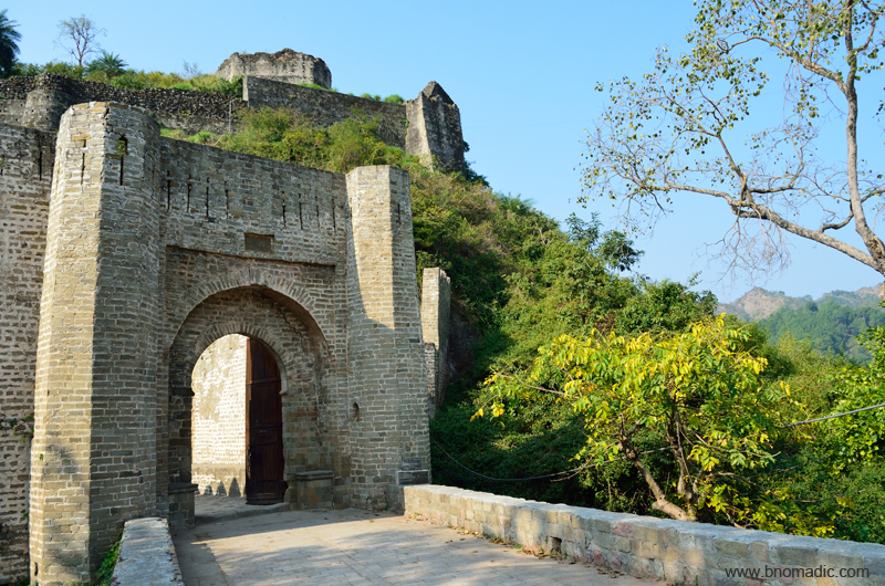
The ASI ticketing counter and main entrance of the Fort. More images at Flickr Photoset

The Fort from near the main entrance. Please visit Flickr for more images of the region
The Ranjit Singh Gate. Please visit Flickr Photoset for more images of the region

Aman and Sarabjit studying the details of the gate and fortification wall. More at Flickr
As one approaches the fort through the main entrance adjacent to the ASI museum, an imposing gate associated with Ranjit Singh leads to a protected enclosure. The fortification wall is strikingly fitted with protective features like platform for guards as well as slits for sharpshooters at its back. Ahead, the ascent to the main section is protected by another line of fortification wall beyond which yet another gate secures entrance to the initial platform. Called the Jahangir Darwaja, this is said to be the earlier outer gate of the fort from Hindu times and as Alexander Cunningham pointed out in 1875, its original name was still now known.
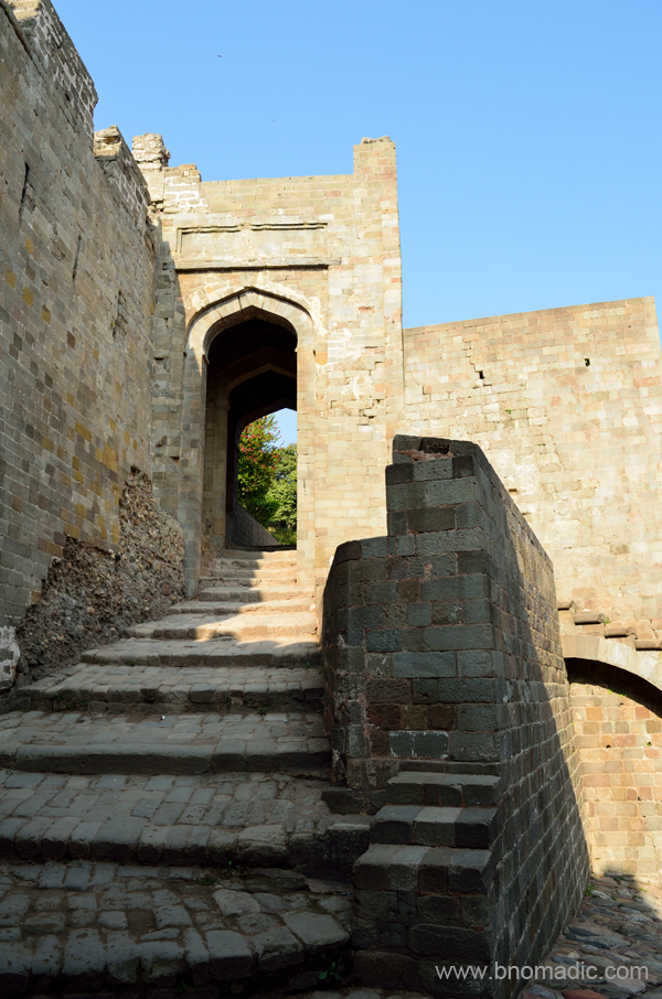
The Jahangir Darwaza
For its strategical position in the foothills north of prosperous Punjab, the Fort of Kangra had its full share of the vicissitudes of the history of north India. Then known as Bhima Nagar after the pandava Bhima, the Fort was conquered by Mahmud Gazhni on his fourth expedition in the year 1009. Mohammed Tughlaq conquered it in 1337. Jahangir visited the valley via Siba and Guler in the winters of 1662. The Fort remained in the possession of the Mughals till 1783 after which a Sikh chieftain Jai Singh Kanheya captured it. Four years later, the Fort came under the possession of Sansar Chand who became the supreme ruler of the Kangra Valley. In 1809, the Fort was occupied by Ranjit Singh after which the British took over. As the British left the valley, the Fort remained neglected for a long time until it came under the management of the ASI.
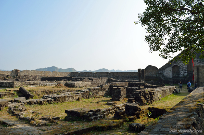
The topmost platform of the Fort, the core area, is secured by yet another line of fortification wall. This platform is approached through a gate facing the Jayanti Devi temple on an opposite hilltop. After passing through a small gate, we reached the innermost courtyard where once stood the palace of the Rajas, which is now in ruins. The courtyard contains the temples of Lakshmi Narayan, Ambika Devi and a Jain temple with a stone image of Adinath which is more than five centuries old. Covering the ruins like a giant umbrella is a Bodhi tree which is said to be very old. Although much of the original fortification is now in ruins as seen elsewhere in this Fort but it is here where the destruction of the April 1905 earthquake could be observed more visibly.

Gateway to the main courtyard. More at Flickr

The main courtyard inside the Fort complex. More images from the region at Flickr Photoset

The giant Bodhi tree in the courtyard. The dome of the Ambika Mata temple is a later addition.

The amalakas and other debris in the courtyard. Please visit Flickr for more images of the region

The surviving wall of the Lakshmi Narayan Temple, one of the most impressive structures inside the Fort.

Among the abundant traces of structures nearby, a stone-lined well and the shapes of some multi-roomed structures along with some freestanding pillars could be spotted. More at Flickr
Some more ruins adjacent to the courtyard. Please visit Flickr for more images of the region
Within the courtyard a number of amalakas along with other broken remains were strewn around on the ground. Among the abundant traces of structures nearby, a stone-lined well and the shapes of some multi-roomed structures along with some freestanding pillars could be spotted. Bearing the brunt of the earthquake, the surviving walls of one of the most impressive structures in the Kangra Fort, said to be the Lakshmi Narayan temple stand on a raised platform that makes it nearly impossible to understand its original layout. The top of the Fort lies further up and is approached by a series of steps from adjacent to the temple ruins. With everything in ruins, not much could be gathered on the top apart from a wide ridge and wide open valley views. Located close by towards the main market of Kangra, the ancient temple of Vajreshwari Devi also attracted the attention of invaders, just as the Fort.
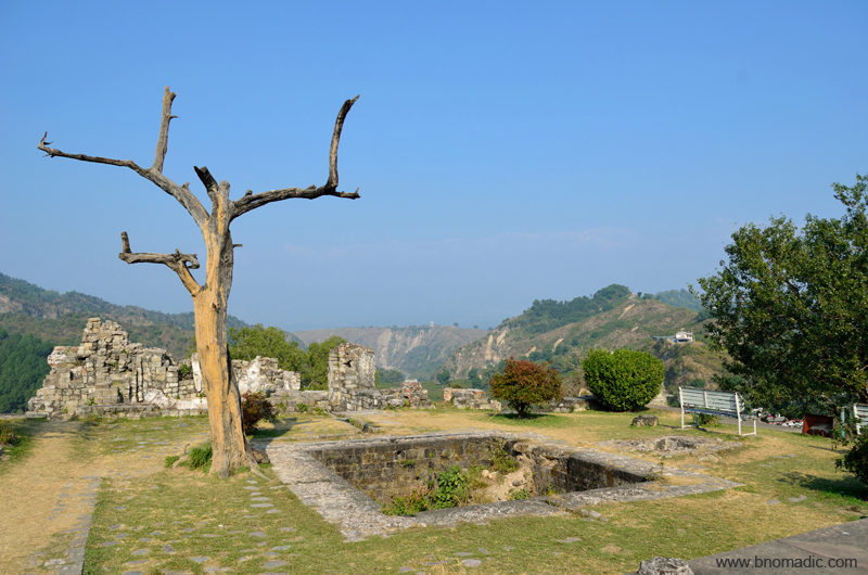
The topmost section of the Fort. Please visit Flickr Photoset for more images of the region

Atop the Fort; with the development of modern artillery, forts may have lost their political importance but remain a picturesque reminders of the feudal past or a preferred haunt of young couples as in this case.

View across the Manjhi Gorge. Jahangir was so fascinated by the beauty of the Valley that he desired to build a summer residence there. The foundations of a palace were actually laid in village Gagri, close to Kangra. The work was abandoned, as later he preferred Kashmir. More at Flickr
The crumbling walls of the Fort and the Banganga down below. More images at Flickr Photoset

Some select rubble from the Fort lined outside the ASI museum. The sculptural friezes were inset in the walls of the structures inside the fort.
As we sat lunching at the cafeteria outside the main Fort complex, we mused over the fact that how colourful and rich the culture of Kangra must have been in its heydays. The café was managed by the royal Katoch family of Kangra as also a small museum and an arts gallery within the same complex. While the famous paintings and Kangra art was practised in the foothill towns of the valley such as Guler, Tira Sujanpur, Alampur and Nadaun, etcetera, the Valley was also famous for producing fragrant rice, sugar and jaggery. Deriving its origin from “kan-gra” or the ear-shapers, the Valley of Kangra was the ancient destination for surgical operations related to restoration of noses and ears by surgeon community called Kangheras.

Paintings and cuttings at display inside the Royal Museum. More images from the region at Flickr


Love it!
Thanks for sharing. 🙂
Thanks 🙂 Keep visiting bNomadic for more such travel stories!
Loved the pictures. I am adding this place to my list.
Thanks for stopping by the blog Shanta! You wont regret visiting this historical wonder. Keep visiting bNomadic 🙂
This was a detailed virtual tour!
Great frames all.
Thanks Indrani for dropping by the blog. Glad you liked it. Keep visiting bNomadic 🙂
Beautiful fort. Well captured.
Thanks Niranjan! Happy to know you liked it. Keep visiting bNomadic for more such travel stories 🙂
Looks like a fascinating place to visit. Thanks for the interesting pictures and information. 🙂
Thanks Jane for stopping by the post. Indeed a beautiful place, especially in winters. Keep visiting bNomadic for more such travel stories 🙂
Very grand view of the fort. Would love to visit sometime.
Thanks Rajesh for dropping by the blog. Do visit the Fort. Keep visiting bNomadic 🙂
One of the most famous forts of the Hills, I did not know it was so big. Great post !
Thanks Puru. Glad you liked it. Keep visiting bNomadic 🙂
Very informative post.. nice captures
Thanks 😊 Keep visiting bNomadic for more such travel stories. ☺
It is a wonderful fort, but it was conquered many times and was always changing hands so i don’t think it was impregnable
Hehe ya! That’s precisely what I thought when I first heard that the Fort has been labelled to be impregnable by many historians. Arguments in favor are that in absence of any specific record whether the “current premises” of the Fort were actually seized by Ghazani and Tughlaq, there appears to be some confusion on use of force. Historians also maintain that Mughals camped for months and months outside the Fort across the deep gorges to gain entrance into the Fort. Their strategy was to stop the supplies and then enter. The folklore says that even Sikander and Dara were unable to enter into the Fort. After the 15th century, the Fort changed hands under treaties and agreements or alliances but not by way of force which is why historians say that it was impregnable.
Fantastic.Really loved your chronicles of Kangra. I have passed it many times but never stopped to explore. About time. dding to my wish list. 😉
You must. Worth a visit. Budget at least 4-5 hours for it. 🙂
Nice post.. And detailed too…!
Thanks! Hope you’d find it useful as well. Keep visiting bNomadic for more travel stories 🙂
sure thing!!! cheers!!! n try drop by on mine as well.. i could learn a thing or two from you guys!!! 🙂
Following already Sir! Looking fwd to remain in touch.
sure thing!! and please, the name is sudersan! 🙂
cheers! 🙂