 bNomadic
The following is a page entry from On Road through the trans-Himalayan Region. To read complete travel memoirs and trip report, please visit here.
Chapter 15 of 22

The road to Padum branches off the NH 1D on the left bank of the Suru. More pics and information at Flickr Photoset
We planned to start at the earliest but the delay on part of the hotel staff in preparing breakfast deferred our departure by an hour. By the time the hotel staff prepared morning meal for us, I wafted towards the bakery shops in the market and bought rich supply of locally-baked fruit cakes as well as biscuits, canned juice and water bottles, etc. At about 0805hrs, we left the hotel and headed straight to the fuel station, located on the Leh road after the bridge of the Suru River, and got the fuel-tank topped up. Having washed the 10L-canister from inside with some fuel, we got that too topped up. A feeble container to hold diesel, the canister later needed to be babysit. Although, I had successfully procured leak-proof as well as fume-proof canisters for the trip but for the last minute change-of-plans we were now carrying a cheap plastic container, something which is readily available in Manali, Leh or Kargil. For now, I kept the canister in the vehicle-trunk packed around by luggage-walls.
Administratively a part of Kargil, the Suru Valley is one of the most agriculturally productive valleys of Ladakh
The road to Zanskar’s administrative headquarter Padum branches off the NH 1D, on the left bank of the Suru, immediately after the iron-bridge on the gushing river. Past a few cantonment buildings as well as the administrative headquarters of Kargil, the tarred road outlined by poplars enters a green valley. Contrary to yesterday’s experience on the Leh-Kargil stretch where the influence of Buddhism kept decreasing as we neared Kargil, travelling on the current road meant quite the opposite. Buddhism, once again, takes the centre-stage in the Stod Valley after crossing the Pensi La.
A majority of the population of the Suru valley comprises orthodox Sunnis with some Shias as well. Also known as Balti, they are crossbreed of Dards (from Dardistan) and the Tibetan-Mongolia descendants. In the olden times, this region might have been a centre-point of Buddhist activities as is indicated by the presence of the Kushan-age Buddhist inscriptions and images in this valley.
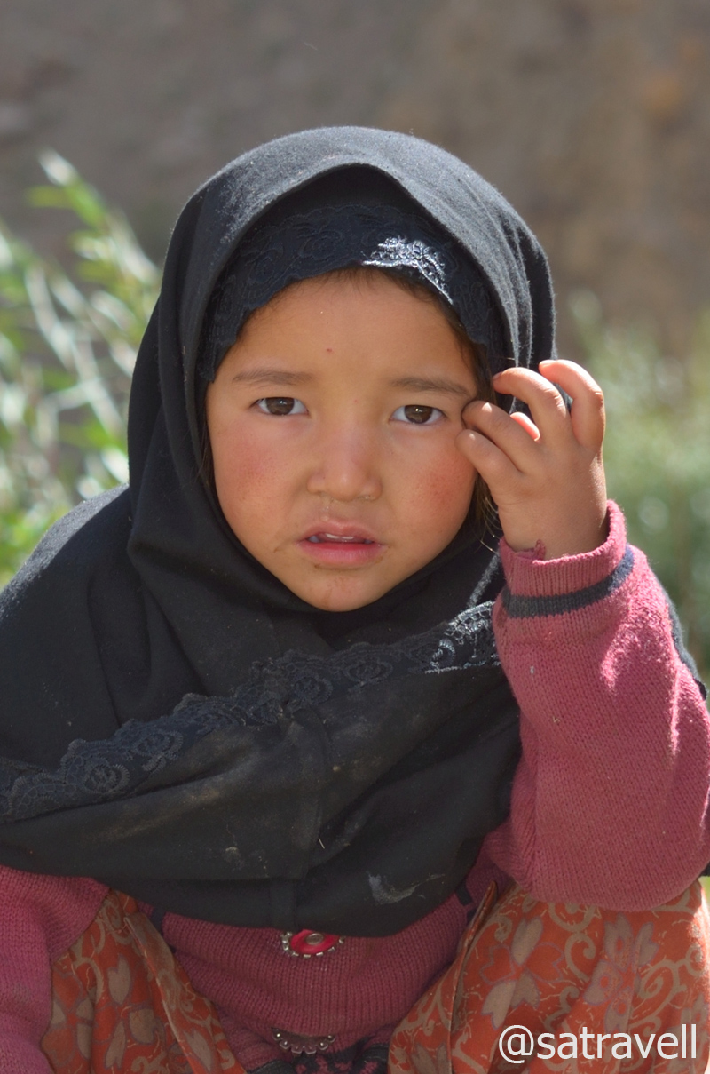
A crossbreed Balti kid in Salaskot village
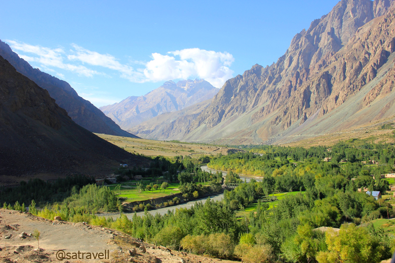
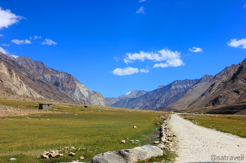
With not much of gathered information on the area we were venturing into, excitement build up was palpable. In spiritual terms this was no less than the pursuit of salvation. Flanked by Zanskar on right bank and the Great Himalayan Range on left bank of the Suru, the valley widens as the road meanders, alongside the left bank, through vegetation-rich Islam-dominated settlements. Located at a distance of 27km from Kargil, settlements at Kumbathang are beautifully spread in the bowl-shaped valley.
A vegetation-rich stretch ahead in the Suru Valley. For more pics and info of the region, please visit Flickr Photoset
Cruising on a freshly tarred road, we took an hour and a half to cover a distance of 42km to reach the first major settlement of Sankoo (2979m) after passing through eight – nine settlements including Titichuming, Gramthang, Salaskot, Pharona, Thona, Kilmarcha, Thang, etc. Surrounded by a dense cover of manmade forest comprising poplars, willows, apricots and wild roses, etc., Sankoo is also known as Gulmarg of Ladakh. Drained by Kartse and Nakpochu streams, tributaries of the Suru, the picturesque picnic spot Sankoo is bounded by russet mountains all around. Comprising a few bakeries, tea shops, guesthouses, ATMs, the township is practically the last place to replenish supplies for the drive ahead to Padum.
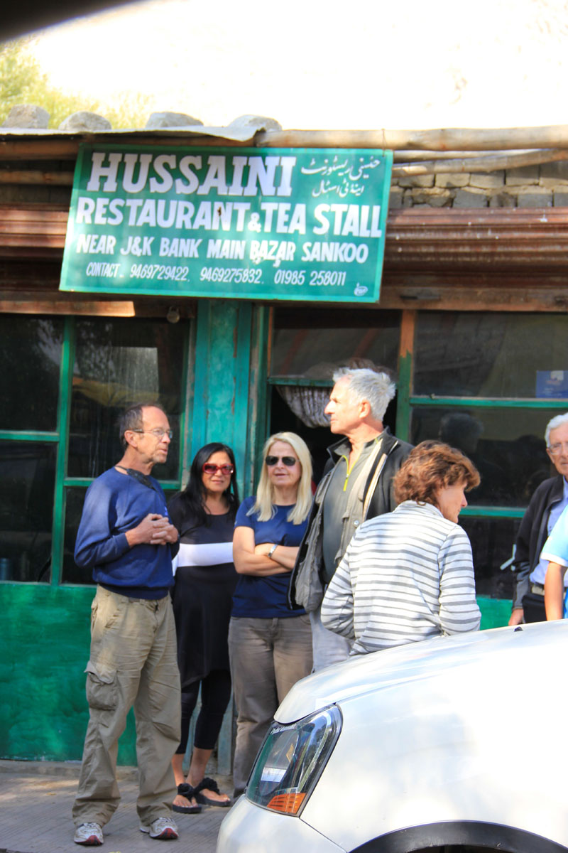
A tea shop at Sankoo

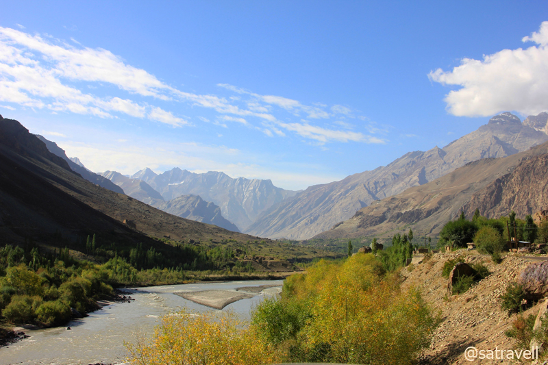
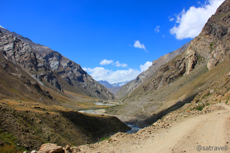
With Zanskar to left and the Great Himalayan Range on the right (of the frame), the Suru River creating an optical illusion downstream. For more pics and information of the region, please visit Flickr Photoset
With some rough sections while twice exchanging banks across the river, the road ahead gradually climbs through village Karpokhar and Thamo to Purtickche (3186m) through a narrowing valley. With a few guesthouses including a modest JKTDC hut, Purtickche is located just at the right spot offering splendid views of Nun Kun massif; Nun peak – 7135m and its neighbour peak Kun – 7077m separated by a glacier four kilometre in length. The grandeur of the landscape warranted a small stop which I utilised to observe and identify the natural formations as well as landmarks around.

In the shadow of The Great Himalayn Range; captured from a point near Purtickche. More pics at Flickr Photoset
Barring a few information boards, in Urdu, the entire road-length in this desolate terrain was rarely marked by sign-boards. So for all the distance and altitude related information, I heavily counted on my Garmin GPS device which proved to a life saviour at few occasions in Kashmir. The nonexistence of sign-boards continued to be a concern in the Kashmir valley as well.

A close-up of the Nun (R)-Kun (L) Massif. For more information and pics of the region, please visit Flickr Photoset
A few kilometres ahead at village Kargee (3185m) past Shanshi nalah, the road bisects for a few kilometres alongside a few settlements on both sides of the river. We crossed an iron-bridge and took the road passing through village Namsuru on the right bank of the river as advised by a village elderly. “The road on the right bank is better as it has more khaartol (blacktop) and both the roads, passing through different villages on either bank of the Suru, converge after 14-15km”, he said.

Cultivated fields of Panikhar and view towards Shanshi Nala. More pics and info at Flickr Photoset
With a few villages spread around the opposite side of the Suru, the motorway, ascending in hairpins from the river bed, passes through a striking vegetation-rich region of the Suru Valley. The energetic Suru River originates from Panzella Glacier, near the Pensi La, and joins the Indus after meandering in the Himalayas for about 185km. The agriculture-rich area also acts as a popular station for the famous trans-Himalayan traverse between Ladakh and the Kashmir Valley. The chief agriculture produce in this region include barley, wheat, millet, beans and a variety of vegetables.

Sloping on Zanskar and looking at the Great Himalayan Range. For more info and pics, please visit Flickr Photoset
The tarmac on the road disappeared after 60km from Kargil and, although we were very hopeful of its reappearance, the condition of the road only worsened. Depending on the terrain we were driving through, the road-condition kept altering from bad to worse to worst. The only silver lining was that the current condition was still better than the Losar to Gramphu road-stretch. The sudden variation in road condition merited a recheck of the fuel canister. It was all fine as of now.

Pk Parkachik 5107 m and Tongul village
As the tarmacked road ceases to exist before approaching the Parkachik ridge, the narrow bumpy motorway ahead often diverges, in form of shortcuts, for a few kilometres to converge again. In a less-frequented valley with zero help from sign-boards, such diversions may confuse initially but as a golden rule keep yourself as lower as possible and stay close to the river alongside its right bank.
Driving on the slopes of the Parkachik La (3810m), the narrow bumpy road ahead climbed to reach village Parkachik (3570m) located on the other side of the ridge. Marked by extensive green terrace-fields and old houses, the village is located, at a distance of 83km from Kargil, in the shadow of Nun and Kun peaks and also comprises a JKTDC accommodation as well as mosques.

Parktik Glacier tonguing the Suru and Parkachik ravines. More pics and info of the region at Flickr Photoset
Owing to an on-going blasting work on the Zanskar mountainside to create a network of motorways and connect the Suru valley with other adjacent valleys, the next 20km-stretch on the motorway ahead after the village surpassed even the Losar – Gramphu stretch when it came to driving on rocks as well as slates, by-product of the blasting process. The beginning of this stretch is marked by the Parktik Glacier osculating with the boisterous Suru on its left bank. Sliding from the Nun-Kun slopes, the huge 300ft blackened-icefall looks as if the massif is tonguing the energetic Suru River flowing through the Parkachik ravines.

Rungofarka and Lingsarmo. For correct nomenclature, identification, info and pics, please visit Flickr Photoset
Driving through the tricky stretch, partly due to road-condition, the nauseating smell of diesel, now snowballing inside the cabin necessitated repositioning of the luggage as well as the canister-baby. The luggage placed around the fuel-canister had soaked the leakage from it, an act which was even more problematic than the pong itself. Burying aside the frustration caused by the workers at the blasting sites due to lack of coordination between the signal-guides, which wasted an hour, we reached the village Zolidok (4015m), an idyllic tea-break destination.
We took almost 160min to cover the 30km-stretch between Parkachik and Zolidok. On the way, the bumpy road gradually climbed alongside the right bank of the Suru through some of the worst stretches on the Kargil-Padum road. Laden with gravels as well as slates, the lonesome stretch of the motorway passed through splendid landscape encompassing green-red slopes, abandoned shelters, rocky mountain faces with icefalls and blackened-hanging glaciers on the left bank of the river, etc. Bestowing a unique contrast in the landscape with green to red shades of the vegetation, the valley seemed to be embracing the onset of winters. Past an abandoned Police Check Post at Shafat (3920m), the road-condition improved a bit and was surrounded by glacial leftovers included lakelets throughout.
Also in the frame, an abandoned Police Check Post. For more info and pics, please visit Flickr Photoset

A colourful landscape ahead. For more information and pics of the region, please visit Flickr Photoset

Divide between Zanskar and the Great Himalayan Range. For more info and pics, please visit Flickr Photoset

Embracing the onset of winters, Glacial lakelets and Alfalfa ahead. More pics and info at Flickr Photoset
Apart from oblique views of Nun-Kun, the prized natural-formation included that of the Shafat, Rungofarka as well as Lingsarmo Glacier, situated adjacent to Rungofarka (6495m) and Lingsarmo (6955m) peaks. Originating from the glacier, said to be melting at an alarming rate, on the left bank of the Suru River or Karcha Nar, the Shafat nallah join the river flowing below. On a terrain on which several streams originating from the Zanskar Range overpassed the motorway, important camping grounds marked by emergency shelter-huts (labour huts) included Samodangsa, Gulmatonga, Yumlun, Shafat, Latapsa, Sangma Kurpo, etc. Views from the village Zolidok included that of Hamjul Glacier giving rise to a stream on the left bank of the Suru River (or Sangpoo River as known here).
View southwards; captured enroute to Zolidok. More pics and info at Flickr Photoset
View and read more on the area at the Zanskar Region Photoset on Flickr
You may also like to subscribe to the email updates, of the remaining chapters, by entering your email id in the sidebar.


Pingback: Retracing The Treaty Road | bNomadic
Pingback: On Road through the trans-Himalayan Region | bNomadic
wow! you have clicked so beautiful breathtaking photographs! I have been there some 10/12 years back, but Leh from your lens look more beautiful than i remember it… Good work!
Thank you for the visit and for the generous praise. Yes Leh is BEAUTIFUL! 🙂
This is awesome. With all the road work happening maybe it will be easier to travel but nature will surely be compromised. Loved the Balti kid. bunch of foreigners in the tea shop shows how they love to discover the unknowns in our country. What a trip you have had. This surely deserves to get published, think about it.
Thanks. Yes definitely the road widening will lead to increased traffic on the route. Which will, in turn, impact the ecology of the region but there is always a price to be paid for infra-development. The Baltis are a very handsome race. As for getting published, 🙂 all in good time.
Loking at your pictures makes it doubly difficult to think that I am going to sit for the whole day in my office 😀
Visiting Ladakh again this September. You are more than welcome to join us. 🙂
Absolutely fantastic pictures and narrative…loved it all 🙂
Thanks for dropping by at my blog. Your feedback is highly appreciated. Hope you’d want to visit again and know more of the area. Thanks for the encouragement.
These are great pictures (as always)
Thanks Swati for the encouragement (as always)!
Great detailed post and the Pictures are just awesome.. 🙂
Thanks Harsha for showering my blog with appreciation.Keep visiting.
Wow! you have done a great job at photographing this beautiful place. Hope to visit it sometime.
Thanks Avada for stopping by! Hope you’d find the contents useful too. Keep visiting. More in store.
Excellent landscape shots!!
http://rajniranjandas.blogspot.in/2013/08/the-pier.html
Thank you.
Wow was the only thing that I could say. Leh is on the cards for me!
http://www.volatilespirits.com
Thanks Anupama for dropping by! You should definitely visit the trans-Himalayan region before it gets too crowded. Hope you’d find the content useful too. Keep visiting!
Pingback: The sliding Darung Drung in Zanskar | bNomadic
Hey, I came across your blog, while doing some research. Love the write-up and pictures. Interestingly a lot of the comments here seem to incorrectly assume that these pictures are of places in Leh. Just wanted to clarify that Leh is actually the name for a town in Ladakh (after which 1 of the 2 districts in Ladakh is named) and I don’t think these pictures are from there. In fact, these images are of the Suru valley which lies in Kargil district (the 2nd district in the Ladakh region). It falls on the way to Zanskar as is evident from your article. I know this for certain because I come from a village in Suru and am familiar with some of views captured so beautifully by you.
I am working on opening a camp site in Suru for mountaineering and other adventure sports. Would love to hear your view on that topic since you have traversed the area as a tourist.
Yes absolutely Aijaz Rasool ji, the current portion of the travel-log pertains to Suru Valley only.
Starting an adventure campsite would be a fantastic idea for both adventure seekers and locals. The area rightly deserves to be among the top adventure sites in the Himalaya. Plenty of opportunities, I would say.
These places are just magical! And the photos show it perfectly! I am too am going to visit here next June! Even more excited after these pictures!
You should definitely plan a visit (and time it well). Keep visiting for more…